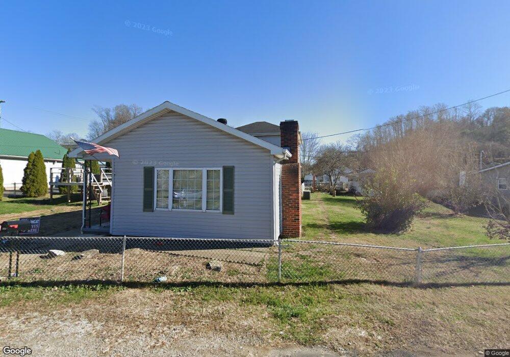
107 North St Unit JO-18 Coal Grove, OH 45638
Estimated Value: $104,127 - $141,000
3
Beds
1
Bath
1,406
Sq Ft
$92/Sq Ft
Est. Value
About This Home
This home is located at 107 North St Unit JO-18, Coal Grove, OH 45638 and is currently estimated at $129,032, approximately $91 per square foot. 107 North St Unit JO-18 is a home located in Lawrence County with nearby schools including Dawson-Bryant Elementary School, Dawson-Bryant Middle School, and Dawson-Bryant High School.
Ownership History
Date
Name
Owned For
Owner Type
Purchase Details
Closed on
Oct 16, 2020
Sold by
Estate Of Elizabeth Webb
Bought by
Webb Jack K and Compliment Tina Louise
Current Estimated Value
Purchase Details
Closed on
Oct 2, 2020
Sold by
Compliment Tina Louise and Compliment Michael A
Bought by
Compliment Tina Louise and Compliment Michael A
Purchase Details
Closed on
Jan 1, 1987
Bought by
Webb Jack and Webb Elizabeth
Create a Home Valuation Report for This Property
The Home Valuation Report is an in-depth analysis detailing your home's value as well as a comparison with similar homes in the area
Home Values in the Area
Average Home Value in this Area
Purchase History
| Date | Buyer | Sale Price | Title Company |
|---|---|---|---|
| Webb Jack K | -- | None Available | |
| Compliment Tina Louise | $52,500 | None Available | |
| Webb Jack | -- | -- |
Source: Public Records
Tax History Compared to Growth
Tax History
| Year | Tax Paid | Tax Assessment Tax Assessment Total Assessment is a certain percentage of the fair market value that is determined by local assessors to be the total taxable value of land and additions on the property. | Land | Improvement |
|---|---|---|---|---|
| 2024 | -- | $25,230 | $4,020 | $21,210 |
| 2023 | $852 | $25,230 | $4,020 | $21,210 |
| 2022 | $849 | $25,230 | $4,020 | $21,210 |
| 2021 | $629 | $20,650 | $3,280 | $17,370 |
| 2020 | $455 | $20,650 | $3,280 | $17,370 |
| 2019 | $453 | $20,650 | $3,280 | $17,370 |
| 2018 | $402 | $18,790 | $2,990 | $15,800 |
| 2017 | $401 | $18,790 | $2,990 | $15,800 |
| 2016 | $376 | $18,790 | $2,990 | $15,800 |
| 2015 | $449 | $20,480 | $2,990 | $17,490 |
| 2014 | $421 | $20,480 | $2,990 | $17,490 |
| 2013 | $421 | $20,480 | $2,990 | $17,490 |
Source: Public Records
Map
Nearby Homes
- 135 Lane St
- 125 Center St
- 514 Lane St
- 204 Dutey Dr
- 519 Lane St
- 805 1/2 High St
- 309 High St
- 309 High St Unit LAO-5
- 119 Remy St
- 103 Carrico Dr
- 156 Township Road 181
- 3107 S 4th St
- 342 Township Road 296
- 2088 State Route 243
- 2721 S 8th St
- 2726 S 9th St
- 2626 S 11th St
- 2616 S 13th St
- 321 Wyanoke St
- 2604 S 8th St