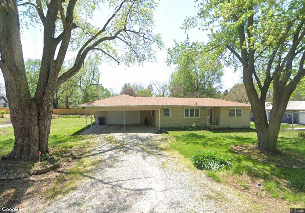
107 Rader St Rogersville, MO 65742
Estimated Value: $162,732 - $188,000
2
Beds
--
Bath
1,016
Sq Ft
$170/Sq Ft
Est. Value
About This Home
This home is located at 107 Rader St, Rogersville, MO 65742 and is currently estimated at $173,183, approximately $170 per square foot. 107 Rader St is a home located in Webster County with nearby schools including Logan-Rogersville Primary School, Logan-Rogersville Upper Elementary School, and Logan-Rogersville Elementary School.
Ownership History
Date
Name
Owned For
Owner Type
Purchase Details
Closed on
Sep 8, 2021
Sold by
Litton Homes Llc
Bought by
Litton Homes 4 Llc
Current Estimated Value
Purchase Details
Closed on
Aug 27, 2020
Sold by
Garner Marilyn E
Bought by
Garner Marilyn E and Koumiss Bryan J
Purchase Details
Closed on
Aug 17, 2020
Sold by
Litton Homes Llc
Bought by
Garner Marilyn E
Purchase Details
Closed on
Apr 10, 2020
Sold by
Keck Tanya Lee
Bought by
Litton Homes Llc
Purchase Details
Closed on
Feb 24, 2020
Sold by
Young Sharon Davis
Bought by
Keck Tanya Lee
Create a Home Valuation Report for This Property
The Home Valuation Report is an in-depth analysis detailing your home's value as well as a comparison with similar homes in the area
Home Values in the Area
Average Home Value in this Area
Purchase History
| Date | Buyer | Sale Price | Title Company |
|---|---|---|---|
| Litton Homes 4 Llc | -- | -- | |
| Garner Marilyn E | -- | -- | |
| Garner Marilyn E | -- | -- | |
| Litton Homes Llc | -- | -- | |
| Keck Tanya Lee | -- | -- |
Source: Public Records
Tax History Compared to Growth
Tax History
| Year | Tax Paid | Tax Assessment Tax Assessment Total Assessment is a certain percentage of the fair market value that is determined by local assessors to be the total taxable value of land and additions on the property. | Land | Improvement |
|---|---|---|---|---|
| 2024 | $722 | $10,660 | $0 | $0 |
| 2023 | $688 | $10,660 | $0 | $0 |
| 2022 | $699 | $10,660 | $0 | $0 |
| 2021 | $679 | $10,660 | $0 | $0 |
| 2020 | $608 | $9,060 | $0 | $0 |
| 2019 | $608 | $9,060 | $0 | $0 |
| 2018 | $562 | $9,060 | $0 | $0 |
| 2017 | $556 | $9,060 | $0 | $0 |
| 2016 | $523 | $8,470 | $0 | $0 |
| 2015 | $455 | $8,470 | $0 | $0 |
| 2012 | -- | $8,470 | $0 | $0 |
Source: Public Records
Map
Nearby Homes
- 000 State Highway B
- 111 S Mill St
- 112 S Mill St
- 102 S Mill St
- The Manhattan Plan at Jamestown
- The Charleston Plan at Jamestown
- The Edgewood Plan at Jamestown
- The Reno Plan at Jamestown
- The Raleigh Plan at Jamestown
- The Dayton Plan at Jamestown
- The Oakwood Plan at Jamestown
- 112 W Center St
- 210 B W Clinton St
- 304 Barnard Ave
- 206 N Main St
- 213 Roberson St
- 213 N Marshall St
- 599 N Spring Meadow Dr Unit Lot 51
- 539 N Spring Meadow Dr Unit Lot 61
- 553 N Spring Meadow Dr Unit Lot 58
- 107 Rader St
- 105 Rader St
- 107 Radar St
- 102 Rader St
- 105 Mcdaniel St
- 307 S Main St
- 300 Oakwood St
- 303 S Main St
- 115 Rader St Unit 113
- 115 Rader St Unit 109
- 115 Rader St Unit 115
- 109 Rader St
- 109 Rader St
- 115 Radar St
- 306 S Main St
- 0 Mcdaniel St
- 107 Mcdaniel St
- 301 S Main St
- 102 Mcdaniel St
- 308 S Main St