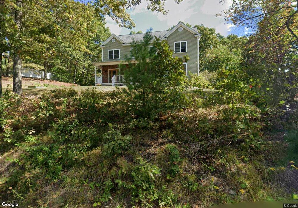
107 Sunset Ln Lunenburg, MA 01462
Estimated Value: $635,000 - $795,000
3
Beds
4
Baths
2,532
Sq Ft
$284/Sq Ft
Est. Value
About This Home
This home is located at 107 Sunset Ln, Lunenburg, MA 01462 and is currently estimated at $720,117, approximately $284 per square foot. 107 Sunset Ln is a home located in Worcester County with nearby schools including Lunenburg Primary School, Lunenburg High School, and Applewild School - Devens Campus.
Ownership History
Date
Name
Owned For
Owner Type
Purchase Details
Closed on
Oct 22, 2002
Sold by
7 Cs Rt and Carpenter George B
Bought by
Carpenter Kenneth B and Carpenter Elaine A
Current Estimated Value
Home Financials for this Owner
Home Financials are based on the most recent Mortgage that was taken out on this home.
Original Mortgage
$220,000
Interest Rate
6.18%
Mortgage Type
Purchase Money Mortgage
Create a Home Valuation Report for This Property
The Home Valuation Report is an in-depth analysis detailing your home's value as well as a comparison with similar homes in the area
Home Values in the Area
Average Home Value in this Area
Purchase History
| Date | Buyer | Sale Price | Title Company |
|---|---|---|---|
| Carpenter Kenneth B | $345,000 | -- |
Source: Public Records
Mortgage History
| Date | Status | Borrower | Loan Amount |
|---|---|---|---|
| Open | Carpenter Kenneth B | $252,000 | |
| Closed | Carpenter Kenneth B | $220,000 |
Source: Public Records
Tax History Compared to Growth
Tax History
| Year | Tax Paid | Tax Assessment Tax Assessment Total Assessment is a certain percentage of the fair market value that is determined by local assessors to be the total taxable value of land and additions on the property. | Land | Improvement |
|---|---|---|---|---|
| 2025 | $8,998 | $626,600 | $141,200 | $485,400 |
| 2024 | $8,299 | $588,600 | $133,200 | $455,400 |
| 2023 | $8,089 | $553,300 | $121,100 | $432,200 |
| 2022 | $7,813 | $454,500 | $100,900 | $353,600 |
| 2020 | $7,899 | $435,900 | $100,900 | $335,000 |
| 2019 | $7,543 | $403,800 | $95,000 | $308,800 |
| 2018 | $7,663 | $389,000 | $95,000 | $294,000 |
| 2017 | $7,481 | $374,400 | $90,700 | $283,700 |
| 2016 | $6,703 | $341,800 | $86,300 | $255,500 |
| 2015 | $6,040 | $329,700 | $81,900 | $247,800 |
Source: Public Records
Map
Nearby Homes
- 878 Flat Hill Rd
- 45 Spring St
- 11 Longwood Dr
- 659 Reservoir Rd
- 2 Oakes Landing
- 802 Reservoir Rd
- 12 Easter Brook Rd
- 9 Winter Hill Rd
- 110 Burrage St
- 12 Hazen Rd
- 4 Ambrose Way Unit 4
- 7 Ambrose Way Unit 5
- 6 Ambrose Way Unit 3
- 17 Ambrose Way Unit 17
- 9 Ambrose Way Unit 9
- 5 Ambrose Way Unit 5
- 3 Ambrose Way Unit 3
- 828 Lancaster Ave
- 4 Hill Ln
- 2 Maple St
- 165 Sunset Ln
- 125 Sunset Ln
- 110 Sunset Ln
- 120 Sunset Ln
- 120 Sunset Ln Unit B
- 120 Sunset Ln Unit A
- 120 Sunset Ln Unit B - 120
- 103 Sunset Ln
- 126 Sunset Ln
- 104 Sunset Ln
- 130 Sunset Ln
- 100 Sunset Ln
- 94 Sunset Ln
- 95 Sunset Ln
- 136 Sunset Ln
- 150 Sunset Ln
- 84 Sunset Ln
- 41 Robbs Hill Rd
- 85 Sunset Ln
- 76 Sunset Ln