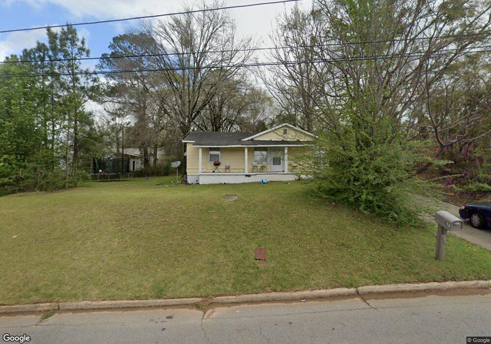
107 Webster St Lagrange, GA 30241
Estimated Value: $53,000 - $166,000
3
Beds
1
Bath
1,256
Sq Ft
$74/Sq Ft
Est. Value
About This Home
This home is located at 107 Webster St, Lagrange, GA 30241 and is currently estimated at $93,239, approximately $74 per square foot. 107 Webster St is a home located in Troup County with nearby schools including Whitesville Road Elementary School, Berta Weathersbee Elementary School, and Rosemont Elementary School.
Ownership History
Date
Name
Owned For
Owner Type
Purchase Details
Closed on
Feb 10, 2011
Sold by
Federal National Mortgage Association
Bought by
Walker Paul
Current Estimated Value
Purchase Details
Closed on
Oct 25, 2001
Sold by
Amy Strong
Bought by
Charles F Akers
Purchase Details
Closed on
Sep 1, 1986
Sold by
Virgil L Strong
Bought by
Amy Strong
Purchase Details
Closed on
Oct 23, 1978
Sold by
Jackson Carter
Bought by
Virgil L Strong
Create a Home Valuation Report for This Property
The Home Valuation Report is an in-depth analysis detailing your home's value as well as a comparison with similar homes in the area
Purchase History
| Date | Buyer | Sale Price | Title Company |
|---|---|---|---|
| Walker Paul | $10,101 | -- | |
| Charles F Akers | $21,500 | -- | |
| Amy Strong | $1,000 | -- | |
| Virgil L Strong | -- | -- |
Source: Public Records
Tax History
| Year | Tax Paid | Tax Assessment Tax Assessment Total Assessment is a certain percentage of the fair market value that is determined by local assessors to be the total taxable value of land and additions on the property. | Land | Improvement |
|---|---|---|---|---|
| 2025 | $529 | $19,380 | $3,320 | $16,060 |
| 2024 | $495 | $18,140 | $3,320 | $14,820 |
| 2023 | $507 | $18,580 | $3,320 | $15,260 |
| 2022 | $491 | $17,580 | $3,320 | $14,260 |
| 2021 | $359 | $11,908 | $1,080 | $10,828 |
| 2020 | $359 | $11,908 | $1,080 | $10,828 |
| 2019 | $336 | $11,140 | $1,000 | $10,140 |
| 2018 | $336 | $11,140 | $1,000 | $10,140 |
| 2017 | $336 | $11,140 | $1,000 | $10,140 |
| 2016 | $335 | $11,094 | $1,000 | $10,094 |
| 2015 | $339 | $11,210 | $1,117 | $10,094 |
| 2014 | $323 | $10,679 | $1,117 | $9,562 |
| 2013 | -- | $9,479 | $1,117 | $8,362 |
Source: Public Records
Map
Nearby Homes
- LOT 33 E Hillside Dr
- LOT 34 E Hillside Dr
- 1201 Whitesville St
- 1191 Whitesville St
- 1404-1406 Hamilton
- 1404 Hamilton Rd
- 304 Butler St
- 0 Bagley St
- 1315 Hamilton Rd
- 1216 Hamilton Rd
- 0 Boggs St Unit 10550243
- 0 Boggs St Unit 10550231
- 0 Boggs St Unit 10550239
- 0 Boggs St Unit 10550250
- 112 Cedar St
- 103 Cedar St
- 101 Cedar St
- 130 Edgewood Ave
- 1186 Lindsey St
- 109 Bell St
- 109 Webster St
- 1413 Whitesville Rd
- 111 Webster St
- 111 Webster St Unit 15
- 119 Webster St
- 1305 Whitesville St
- 101 W Hillside Dr
- 1502 Whitesville St
- 100 Webster St
- 1502 Whitesville Rd
- 121 Webster St
- 103 W Hillside Dr
- W W Hillside Dr
- 1506 Whitesville Rd
- 1412 Whitesville Rd
- 105 W Hillside Dr
- 1412 Whitesville St
- 120 Webster St
- 1508 Whitesville Rd
- 123 Webster St
Your Personal Tour Guide
Ask me questions while you tour the home.