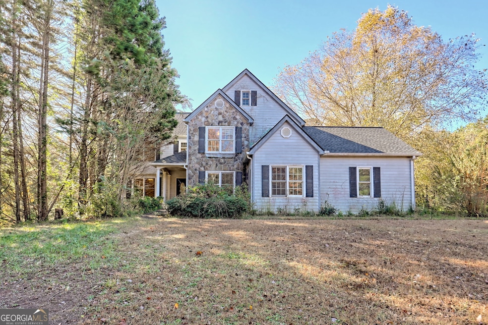
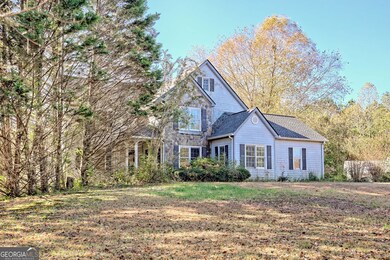
1070 Cannon Bridge Rd Demorest, GA 30535
Estimated payment $1,987/month
Highlights
- Second Kitchen
- 2.86 Acre Lot
- Family Room with Fireplace
- South Habersham Middle School Rated 9+
- Private Lot
- Partially Wooded Lot
About This Home
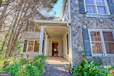
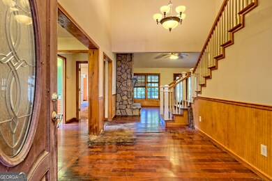
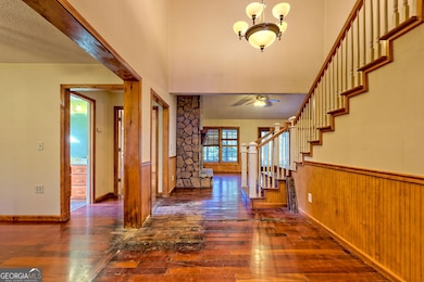
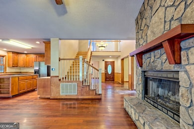
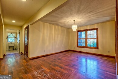
It's Got Good Bones (and Maybe a Few Bruises!) This 2-story DIY playground is big enough for all your renovation dreams (and then some). Honest rundown: The hardwood floors have "lived a little." The carpet has...also lived a little. (We ripped up most of it for you). The entire interior needs a makeover, paint and all, so bring your inner designer! Cabinetry and exterior siding also need a few love taps and a can-do attitude! And what is a DIY project without some plumbing and sheetrock repairs? We've got it all! But hang on...it's not all work: There's a wood-burning fireplace with a gorgeous natural stone surround on the main floor, quartz countertops, maple cabinetry and large cook-top island in the kitchen, beautiful tray ceilings, great closet space everywhere, spacious laundry with sink, screened in porch for bug-free summer nights and early morning coffee therapy, full apartment in basement with second kitchen and second fireplace ideal for guests, in-laws or that one child who "just needs a few more months." Two brand new HVAC units for main floor and upstairs (so your sweat equity doesn't include actual sweat, but basement a/c unit still needs repair.) 2.859 ACRES to roam, garden or park your fleet and only 5 minutes to Wal-mart and Hwy access! Sure, it needs some elbow grease. But with great bones, tons of space, and all the right features hiding under a little dirt and dust, this place could be the one! (Shared driveway easement on record). Call today for a viewing and don't forget your tool-box!
Home Details
Home Type
- Single Family
Est. Annual Taxes
- $1,809
Year Built
- Built in 2004
Lot Details
- 2.86 Acre Lot
- Private Lot
- Level Lot
- Open Lot
- Cleared Lot
- Partially Wooded Lot
Home Design
- Traditional Architecture
- Fixer Upper
- Composition Roof
- Concrete Siding
Interior Spaces
- 2-Story Property
- Tray Ceiling
- Ceiling Fan
- Double Pane Windows
- Window Treatments
- Family Room with Fireplace
- 2 Fireplaces
- Great Room
- Formal Dining Room
- Home Office
- Bonus Room
- Sun or Florida Room
- Screened Porch
- Home Security System
Kitchen
- Second Kitchen
- Built-In Oven
- Cooktop
- Microwave
- Dishwasher
- Kitchen Island
- Solid Surface Countertops
Flooring
- Wood
- Laminate
- Tile
- Vinyl
Bedrooms and Bathrooms
- 5 Bedrooms | 1 Primary Bedroom on Main
- Walk-In Closet
- Double Vanity
- Soaking Tub
- Separate Shower
Laundry
- Laundry Room
- Laundry in Hall
- Dryer
- Washer
Finished Basement
- Basement Fills Entire Space Under The House
- Interior Basement Entry
- Fireplace in Basement
- Finished Basement Bathroom
- Natural lighting in basement
Parking
- Garage
- Parking Accessed On Kitchen Level
- Guest Parking
Outdoor Features
- Patio
- Shed
Schools
- Fairview Elementary School
- South Habersham Middle School
- Habersham Central High School
Utilities
- Cooling Available
- Heating Available
- Electric Water Heater
- Septic Tank
- High Speed Internet
- Phone Available
Community Details
- No Home Owners Association
Listing and Financial Details
- Tax Lot TR2
Map
Home Values in the Area
Average Home Value in this Area
Tax History
| Year | Tax Paid | Tax Assessment Tax Assessment Total Assessment is a certain percentage of the fair market value that is determined by local assessors to be the total taxable value of land and additions on the property. | Land | Improvement |
|---|---|---|---|---|
| 2025 | $1,809 | $323,800 | $31,579 | $292,221 |
| 2024 | -- | $351,240 | $37,476 | $313,764 |
| 2023 | $5,990 | $296,420 | $37,476 | $258,944 |
| 2022 | $6,116 | $259,192 | $37,476 | $221,716 |
| 2021 | $5,548 | $226,532 | $28,108 | $198,424 |
| 2020 | $5,148 | $193,648 | $23,424 | $170,224 |
| 2019 | $5,153 | $193,648 | $23,424 | $170,224 |
| 2018 | $5,113 | $193,648 | $23,424 | $170,224 |
| 2017 | $4,593 | $172,976 | $18,740 | $154,236 |
| 2016 | $2,684 | $432,440 | $18,740 | $154,236 |
| 2015 | $2,627 | $432,440 | $18,740 | $154,236 |
| 2014 | $2,570 | $417,710 | $18,740 | $148,344 |
| 2013 | -- | $122,044 | $18,740 | $103,304 |
Property History
| Date | Event | Price | List to Sale | Price per Sq Ft |
|---|---|---|---|---|
| 11/11/2025 11/11/25 | Pending | -- | -- | -- |
| 11/06/2025 11/06/25 | Price Changed | $350,000 | -9.1% | -- |
| 11/01/2025 11/01/25 | For Sale | $385,000 | -- | -- |
Purchase History
| Date | Type | Sale Price | Title Company |
|---|---|---|---|
| Trustee Deed | -- | -- | |
| Trustee Deed | -- | -- | |
| Trustee Deed | $149,700 | -- | |
| Warranty Deed | -- | -- | |
| Deed | $40,000 | -- |
Source: Georgia MLS
MLS Number: 10635699
APN: 080-039C
Disclaimer: Certain information contained herein is derived from information provided by parties other than Homes.com. All information provided is deemed reliable, but is not guaranteed to be accurate and should be independently verified.
![]() The data relating to real estate for sale on this web site comes in part from the Broker Reciprocity Program of Georgia MLS. Real estate listings held by brokerage firms other than Redfin are marked with the Broker Reciprocity logo and detailed information about them includes the name of the listing brokers. Information deemed reliable but not guaranteed. Copyright 2025 Georgia MLS. All rights reserved.
The data relating to real estate for sale on this web site comes in part from the Broker Reciprocity Program of Georgia MLS. Real estate listings held by brokerage firms other than Redfin are marked with the Broker Reciprocity logo and detailed information about them includes the name of the listing brokers. Information deemed reliable but not guaranteed. Copyright 2025 Georgia MLS. All rights reserved.
- 180 Springbrook Dr
- 129 Rockwind Way
- 161 Springbrook Dr
- 3750 Old Cleveland Rd
- 950 Hancock Rd
- 159 Hardyville Cir
- 1600 Old Athens Hw
- 441 Spiral Hills Dr
- 445 Spiral Hills Dr
- 451 Spiral Hills Dr
- Plan 2604 at Habersham Meadows
- Plan 2131 at Habersham Meadows
- Plan 1709 at Habersham Meadows
- Plan 2307 at Habersham Meadows
- Plan 1902 at Habersham Meadows
- Plan 3119 at Habersham Meadows
- Plan 2408 at Habersham Meadows
- Plan 2100 at Habersham Meadows
- Plan 2628 at Habersham Meadows
- Plan 3105 at Habersham Meadows
