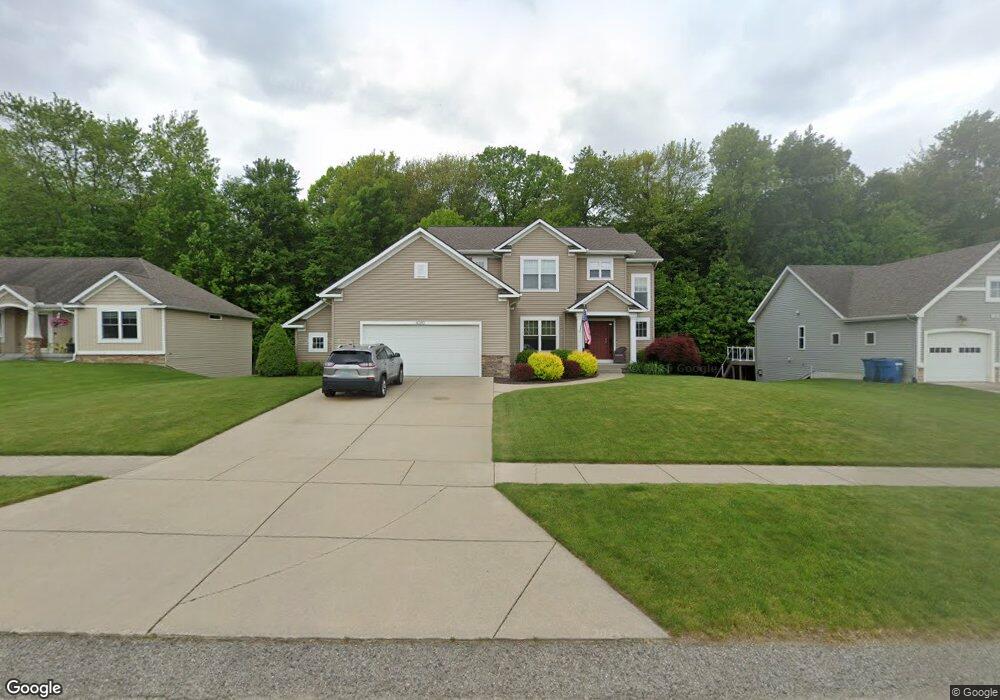
1070 Shore Point Dr SW Byron Center, MI 49315
Estimated Value: $540,967 - $894,000
5
Beds
4
Baths
3,339
Sq Ft
$202/Sq Ft
Est. Value
About This Home
This home is located at 1070 Shore Point Dr SW, Byron Center, MI 49315 and is currently estimated at $674,742, approximately $202 per square foot. 1070 Shore Point Dr SW is a home located in Kent County with nearby schools including Robert L. Nickels Intermediate School, Countryside Elementary School, and Byron Center West Middle School.
Ownership History
Date
Name
Owned For
Owner Type
Purchase Details
Closed on
Oct 17, 2012
Sold by
Margui Kevin J and Rutgers Cory L
Bought by
Margul Kevin J and Margul Cory L
Current Estimated Value
Home Financials for this Owner
Home Financials are based on the most recent Mortgage that was taken out on this home.
Original Mortgage
$224,000
Outstanding Balance
$155,405
Interest Rate
3.55%
Mortgage Type
New Conventional
Estimated Equity
$519,337
Purchase Details
Closed on
Jun 24, 2011
Sold by
Degoa Damian and Degoa Sara
Bought by
Margul Kevin J and Rutgers Cory L
Home Financials for this Owner
Home Financials are based on the most recent Mortgage that was taken out on this home.
Original Mortgage
$233,750
Interest Rate
4.63%
Mortgage Type
New Conventional
Purchase Details
Closed on
Oct 27, 2005
Sold by
Vlaan Properties Inc
Bought by
Degoa Damian and Degoa Sara
Create a Home Valuation Report for This Property
The Home Valuation Report is an in-depth analysis detailing your home's value as well as a comparison with similar homes in the area
Home Values in the Area
Average Home Value in this Area
Purchase History
| Date | Buyer | Sale Price | Title Company |
|---|---|---|---|
| Margul Kevin J | -- | Chicago Title | |
| Margul Kevin J | $279,900 | Chicago Title | |
| Degoa Damian | $48,920 | Lighthouse Title Inc |
Source: Public Records
Mortgage History
| Date | Status | Borrower | Loan Amount |
|---|---|---|---|
| Open | Margul Kevin J | $224,000 | |
| Closed | Margul Kevin J | $233,750 |
Source: Public Records
Tax History Compared to Growth
Tax History
| Year | Tax Paid | Tax Assessment Tax Assessment Total Assessment is a certain percentage of the fair market value that is determined by local assessors to be the total taxable value of land and additions on the property. | Land | Improvement |
|---|---|---|---|---|
| 2025 | $3,454 | $248,400 | $0 | $0 |
| 2024 | $3,454 | $226,000 | $0 | $0 |
| 2023 | $3,304 | $211,500 | $0 | $0 |
| 2022 | $4,604 | $196,900 | $0 | $0 |
| 2021 | $4,481 | $180,400 | $0 | $0 |
| 2020 | $3,041 | $166,800 | $0 | $0 |
| 2019 | $4,373 | $163,300 | $0 | $0 |
| 2018 | $4,283 | $154,800 | $23,800 | $131,000 |
| 2017 | $4,168 | $142,700 | $0 | $0 |
| 2016 | $4,019 | $139,700 | $0 | $0 |
| 2015 | $3,951 | $139,700 | $0 | $0 |
| 2013 | -- | $126,900 | $0 | $0 |
Source: Public Records
Map
Nearby Homes
- 784 Petoskey Stone Dr
- 903 S Center Park Dr SW Unit 14
- 884 S Center Park Dr SW Unit 7
- 760 Petoskey Stone SW
- 760 Petoskey Stone Dr
- 769 Sun Stone Dr SW
- 8733 Cobble Dr
- 8877 Pictured Rock Dr
- 697 Sun Stone Dr SW
- 679 Sun Stone Dr SW
- 8920 Pictured Rock Dr
- 1729 Thyme Dr
- 750 84th St SW
- The Fitzgerald Plan at Walnut Ridge
- The Marley Plan at Walnut Ridge
- The Hearthside Plan at Walnut Ridge
- The Balsam Plan at Walnut Ridge
- The Rutherford Plan at Walnut Ridge
- The Stockton Plan at Walnut Ridge
- The Georgetown Plan at Walnut Ridge
- 1078 Shore Point Dr SW
- 1062 Shore Point Dr SW
- 1054 Shore Point Dr SW
- 1086 Shore Point Dr SW
- 1065 Shore Point Dr SW
- 1079 Shore Point Dr SW
- 8741 Carlisle Dr SW
- 1042 Shore Point Dr SW
- 1094 Shore Point Dr SW
- 1087 Shore Point Dr SW
- 8727 Carlisle Dr SW
- 1102 Shore Point Dr SW
- 1030 Shore Point Dr SW
- 8710 Shore Point Ct SW
- 1102 Shore Pointe SW
- 8744 Carlisle Dr SW
- 8719 Carlisle Dr SW
- 8732 Carlisle Dr SW
- 8702 Shore Pointe Ct SW
- 1110 Shore Point Dr SW