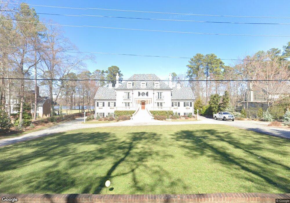
10700 Cherokee Rd Midlothian, VA 23113
Robious NeighborhoodEstimated Value: $922,000 - $2,479,644
4
Beds
3
Baths
3,768
Sq Ft
$507/Sq Ft
Est. Value
About This Home
This home is located at 10700 Cherokee Rd, Midlothian, VA 23113 and is currently estimated at $1,911,548, approximately $507 per square foot. 10700 Cherokee Rd is a home located in Chesterfield County with nearby schools including Robious Elementary School, Robious Middle School, and James River High School.
Ownership History
Date
Name
Owned For
Owner Type
Purchase Details
Closed on
Jul 19, 2004
Sold by
Mccorey William
Bought by
Kiritsis Paul
Current Estimated Value
Home Financials for this Owner
Home Financials are based on the most recent Mortgage that was taken out on this home.
Original Mortgage
$876,000
Outstanding Balance
$426,808
Interest Rate
6.28%
Mortgage Type
New Conventional
Estimated Equity
$1,484,740
Purchase Details
Closed on
Feb 26, 2002
Sold by
Clements Jeffrey K
Bought by
Mccorey William E and Mccorey Anne L
Home Financials for this Owner
Home Financials are based on the most recent Mortgage that was taken out on this home.
Original Mortgage
$673,200
Interest Rate
7.08%
Mortgage Type
New Conventional
Create a Home Valuation Report for This Property
The Home Valuation Report is an in-depth analysis detailing your home's value as well as a comparison with similar homes in the area
Home Values in the Area
Average Home Value in this Area
Purchase History
| Date | Buyer | Sale Price | Title Company |
|---|---|---|---|
| Kiritsis Paul | $1,095,000 | -- | |
| Mccorey William E | $841,500 | -- |
Source: Public Records
Mortgage History
| Date | Status | Borrower | Loan Amount |
|---|---|---|---|
| Open | Kiritsis Paul | $876,000 | |
| Previous Owner | Mccorey William E | $673,200 |
Source: Public Records
Tax History
| Year | Tax Paid | Tax Assessment Tax Assessment Total Assessment is a certain percentage of the fair market value that is determined by local assessors to be the total taxable value of land and additions on the property. | Land | Improvement |
|---|---|---|---|---|
| 2025 | $20,608 | $2,312,700 | $454,500 | $1,858,200 |
| 2024 | $20,608 | $2,235,100 | $444,500 | $1,790,600 |
| 2023 | $19,192 | $2,109,000 | $424,500 | $1,684,500 |
| 2022 | $16,618 | $1,806,300 | $417,500 | $1,388,800 |
| 2021 | $15,629 | $1,642,500 | $412,400 | $1,230,100 |
| 2020 | $15,604 | $1,642,500 | $412,400 | $1,230,100 |
| 2019 | $15,604 | $1,642,500 | $412,400 | $1,230,100 |
| 2018 | $15,509 | $1,632,500 | $402,400 | $1,230,100 |
| 2017 | $14,666 | $1,527,700 | $394,400 | $1,133,300 |
| 2016 | $14,667 | $1,527,800 | $394,500 | $1,133,300 |
| 2015 | $9,099 | $947,800 | $394,500 | $553,300 |
| 2014 | $8,668 | $900,300 | $377,500 | $522,800 |
Source: Public Records
Map
Nearby Homes
- 3841 Stanford Ct
- 10451 Cherokee Rd
- 4210 Southaven Rd
- 3820 Reeds Landing Cir
- 4521 Uppingham Rd
- 11240 Turnley Ln
- 4287 Cheyenne Rd
- 4321 Saratoga Rd
- 11831 Aberdeen Landing Terrace
- 9477 Creek Summit Cir
- 9479 Creek Summit Cir
- 9490 Creek Summit Cir
- 9300 S Mooreland Rd
- 9498 Creek Summit Cir
- 9496 Creek Summit Cir
- 9494 Creek Summit Cir
- 9492 Creek Summit Cir
- 9486 Creek Summit Cir
- 9306 S Mooreland Rd
- 3501 Old Gun Rd W
- 10690 Cherokee Rd
- 10710 Cherokee Rd
- 10720 Cherokee Rd
- 10680 Cherokee Rd
- 3961 Darby Dr
- 10701 Cherokee Rd
- 10715 Cherokee Rd
- 10730 Cherokee Rd
- 10670 Cherokee Rd
- 3951 Darby Dr
- 10731 Cherokee Rd
- 10685 Cherokee Rd
- 3940 Darby Dr
- 10660 Cherokee Rd
- 10740 Cherokee Rd
- 10741 Cherokee Rd
- 10675 Cherokee Rd
- 3941 Darby Dr
- 4240 Pittaway Dr
- 10650 Cherokee Rd
Your Personal Tour Guide
Ask me questions while you tour the home.