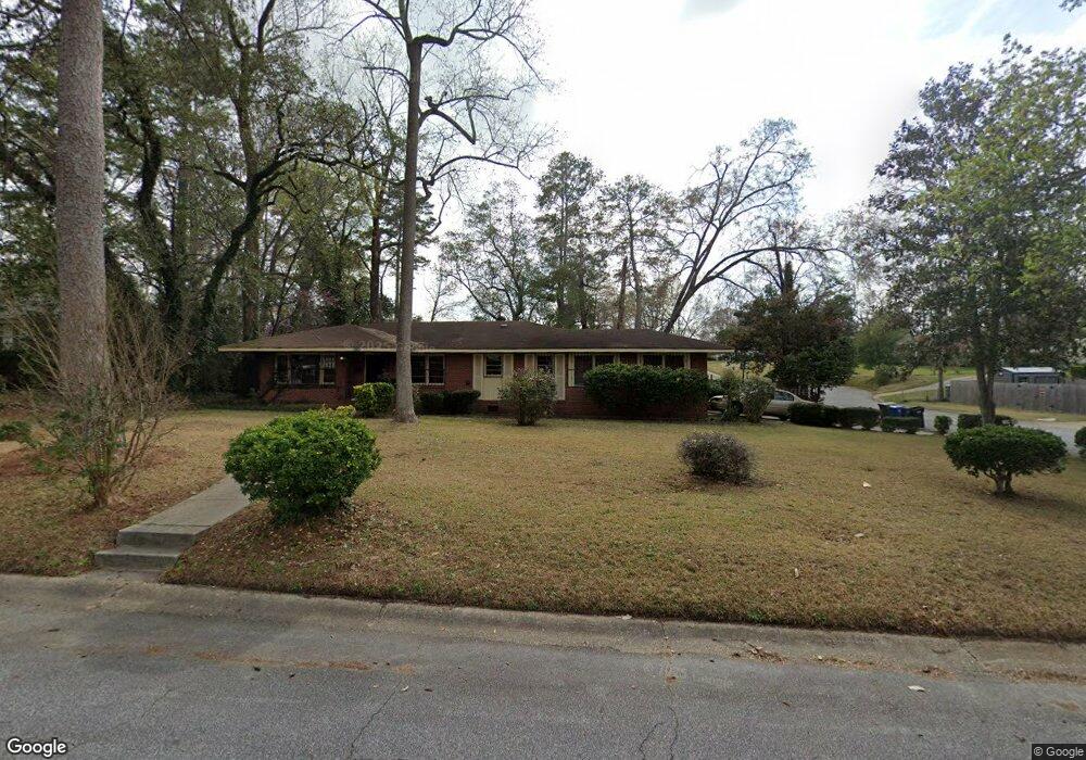
1071 Bolton Ave Columbus, GA 31906
Lindsey Creek Park-Boxwood Estates NeighborhoodEstimated Value: $154,000 - $221,059
5
Beds
4
Baths
2,512
Sq Ft
$77/Sq Ft
Est. Value
About This Home
This home is located at 1071 Bolton Ave, Columbus, GA 31906 and is currently estimated at $193,515, approximately $77 per square foot. 1071 Bolton Ave is a home located in Muscogee County with nearby schools including Rigdon Road Elementary School, Richards Middle School, and Carver High School.
Ownership History
Date
Name
Owned For
Owner Type
Purchase Details
Closed on
Jun 27, 2011
Sold by
Federal National Mortgage Association
Bought by
Turman Frank A and Turman Edna E
Current Estimated Value
Purchase Details
Closed on
Jan 4, 2011
Sold by
Citimortgage Inc
Bought by
Federal National Mortgage Association
Create a Home Valuation Report for This Property
The Home Valuation Report is an in-depth analysis detailing your home's value as well as a comparison with similar homes in the area
Home Values in the Area
Average Home Value in this Area
Purchase History
| Date | Buyer | Sale Price | Title Company |
|---|---|---|---|
| Turman Frank A | $39,900 | -- | |
| Federal National Mortgage Association | -- | None Available | |
| Citimortgage Inc | $84,147 | None Available |
Source: Public Records
Tax History Compared to Growth
Tax History
| Year | Tax Paid | Tax Assessment Tax Assessment Total Assessment is a certain percentage of the fair market value that is determined by local assessors to be the total taxable value of land and additions on the property. | Land | Improvement |
|---|---|---|---|---|
| 2025 | $2,256 | $57,640 | $9,012 | $48,628 |
| 2024 | $2,256 | $57,640 | $9,012 | $48,628 |
| 2023 | $2,270 | $57,640 | $9,012 | $48,628 |
| 2022 | $1,926 | $47,176 | $9,012 | $38,164 |
| 2021 | $1,889 | $46,276 | $9,012 | $37,264 |
| 2020 | $1,890 | $46,276 | $9,012 | $37,264 |
| 2019 | $1,896 | $46,276 | $9,012 | $37,264 |
| 2018 | $1,896 | $46,276 | $9,012 | $37,264 |
| 2017 | $1,902 | $46,276 | $9,012 | $37,264 |
| 2016 | $2,106 | $51,056 | $6,336 | $44,720 |
| 2015 | $2,109 | $51,056 | $6,336 | $44,720 |
| 2014 | $2,111 | $51,056 | $6,336 | $44,720 |
| 2013 | -- | $51,056 | $6,336 | $44,720 |
Source: Public Records
Map
Nearby Homes
- 3122 Glenwood Dr
- 1061 Dunbar Ave
- 1047 Fisk Ave
- 2902 Hood St
- 2925 Colorado St
- 2937 Thomas St
- 2911 Thomas St
- 1301 Rigdon Rd
- 3319 Decatur St
- 2726 Marion St
- 2835 Thomas St
- 2833 Thomas St
- 937 Diggs Ave
- 2829 Thomas St
- 1312 Glenwood Rd
- 2717 10th St
- 2810 Thomas St
- 1054 Lawyers Ln
- 2818 9th St
- 3415 Terminal St
- 1067 Bolton Ave
- 1079 Bolton Ct
- 1103 Bolton Ave
- 1063 Bolton Ave
- 1072 Bolton Ave
- 1080 Bolton Ave
- 1068 Bolton Ave
- 1104 Bolton Ave
- 1059 Bolton Ave
- 1115 Bolton Ave
- 1097 Bolton Ct
- 1064 Bolton Ave
- 3111 Glenwood Dr
- 3103 Glenwood Dr
- 1091 Bolton Ct
- 1112 Bolton Ave
- 1087 Bolton Ct
- 3031 Glenwood Dr
- 1107 Dunbar Ave
- 1109 Dunbar Ave