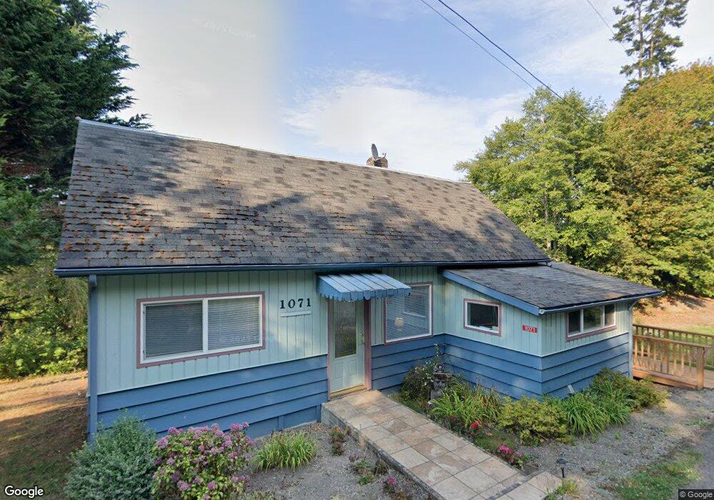
1071 Fairmount Rd Port Townsend, WA 98368
Estimated Value: $486,000 - $680,000
2
Beds
1
Bath
1,146
Sq Ft
$512/Sq Ft
Est. Value
About This Home
This home is located at 1071 Fairmount Rd, Port Townsend, WA 98368 and is currently estimated at $587,297, approximately $512 per square foot. 1071 Fairmount Rd is a home located in Jefferson County with nearby schools including Salish Coast Elementary School, Blue Heron Middle School, and Port Townsend High School.
Ownership History
Date
Name
Owned For
Owner Type
Purchase Details
Closed on
Jul 8, 2005
Sold by
Reid Emma M
Bought by
Reid Richard H and Reid Sandra L
Current Estimated Value
Purchase Details
Closed on
Jun 30, 2005
Sold by
Reid Howard
Bought by
Reid Emma and Reid Richard
Create a Home Valuation Report for This Property
The Home Valuation Report is an in-depth analysis detailing your home's value as well as a comparison with similar homes in the area
Home Values in the Area
Average Home Value in this Area
Purchase History
| Date | Buyer | Sale Price | Title Company |
|---|---|---|---|
| Reid Richard H | -- | None Available | |
| Reid Emma M | -- | None Available | |
| Reid Howard C | -- | None Available | |
| Reid Emma | -- | None Available | |
| Pate & Pate Land Development Inc | -- | None Available |
Source: Public Records
Tax History Compared to Growth
Tax History
| Year | Tax Paid | Tax Assessment Tax Assessment Total Assessment is a certain percentage of the fair market value that is determined by local assessors to be the total taxable value of land and additions on the property. | Land | Improvement |
|---|---|---|---|---|
| 2024 | $3,791 | $468,660 | $282,975 | $185,685 |
| 2023 | $3,791 | $442,502 | $264,863 | $177,639 |
| 2022 | $3,675 | $408,740 | $247,250 | $161,490 |
| 2021 | $3,339 | $358,501 | $236,160 | $122,341 |
| 2020 | $3,241 | $303,876 | $191,730 | $112,146 |
| 2019 | $2,888 | $290,064 | $183,015 | $107,049 |
| 2018 | $2,892 | $276,251 | $174,300 | $101,951 |
| 2017 | $2,589 | $240,369 | $169,300 | $71,069 |
| 2016 | $2,336 | $240,369 | $169,300 | $71,069 |
| 2015 | $2,347 | $240,369 | $169,300 | $71,069 |
| 2014 | -- | $240,369 | $169,300 | $71,069 |
| 2013 | -- | $240,370 | $169,300 | $71,070 |
Source: Public Records
Map
Nearby Homes
- 813 Fairmount Rd
- NKA Lots 41 up Holland Dr Unit 45 - 48 Honeymoon La
- 9999 Holland Dr
- 4809 Old Gardiner Rd
- 690 Naylor Creek Rd
- 9999 Snow Creek Way E
- NKA Snow Creek Way E
- 0 Skidder Hill Rd Unit NWM2400640
- 9999 View Ridge - Lot 4 Dr
- Lot 4 View Ridge Dr
- 6062 State Route 20 Unit 35
- 6062 State Route 20 Unit 55
- 56 Bayview Ln
- 6192 State Route 20
- 9999 S Discovery Rd
- 2600 Center Rd
- 681 Bachelor Rd
- 10955 NKA Rhody Dr
- 491 Bachelor Rd
- 106 Crocker Lake Rd
- 1031 Fairmount Rd
- 1030 Fairmount Rd
- 1120 Fairmount Rd
- 995 Fairmount Rd
- 993 Fairmount Rd
- 1174 Fairmount Rd
- 1172 Fairmount Rd
- 961 Fairmount Rd
- 921 Fairmount Rd
- 702 Fairmount Rd
- 853 Fairmount Rd
- 1234 Fairmount Rd
- 1312 Fairmount Rd
- 841 Fairmount Rd
- 30 Fairmount Hill Rd
- 30 Fairmount Hill Rd
- 1318 Fairmount Rd
- 805 Fairmount Rd