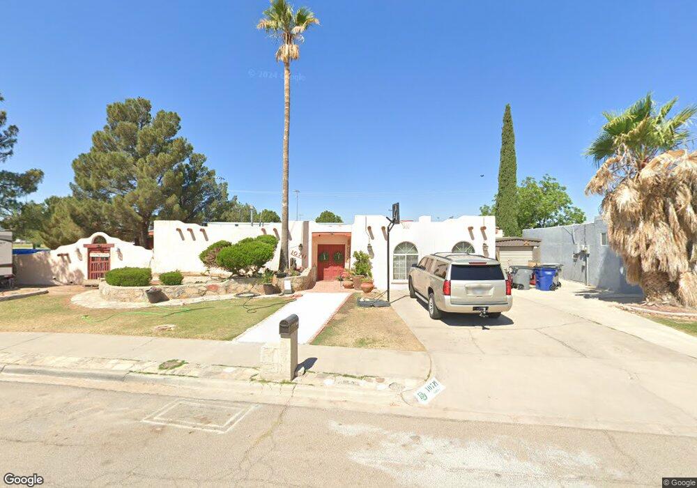
10711 Fury Ln El Paso, TX 79935
Pico Norte NeighborhoodEstimated Value: $229,000 - $278,000
4
Beds
2
Baths
2,077
Sq Ft
$122/Sq Ft
Est. Value
About This Home
This home is located at 10711 Fury Ln, El Paso, TX 79935 and is currently estimated at $253,750, approximately $122 per square foot. 10711 Fury Ln is a home located in El Paso County with nearby schools including East Point Elementary School, Eastwood Middle School, and Eastwood High School.
Ownership History
Date
Name
Owned For
Owner Type
Purchase Details
Closed on
Jan 24, 2002
Sold by
Flores Jose G and Flores Soledad
Bought by
Guillen Rosalia and Herrera Gustavo
Current Estimated Value
Home Financials for this Owner
Home Financials are based on the most recent Mortgage that was taken out on this home.
Original Mortgage
$88,609
Outstanding Balance
$36,035
Interest Rate
7.12%
Mortgage Type
FHA
Estimated Equity
$217,715
Purchase Details
Closed on
Nov 10, 1994
Sold by
Guerrero Francisca F
Bought by
Flores Jose G and Flores Soledad
Home Financials for this Owner
Home Financials are based on the most recent Mortgage that was taken out on this home.
Original Mortgage
$80,900
Interest Rate
8.78%
Mortgage Type
FHA
Create a Home Valuation Report for This Property
The Home Valuation Report is an in-depth analysis detailing your home's value as well as a comparison with similar homes in the area
Home Values in the Area
Average Home Value in this Area
Purchase History
| Date | Buyer | Sale Price | Title Company |
|---|---|---|---|
| Guillen Rosalia | -- | -- | |
| Flores Jose G | -- | -- |
Source: Public Records
Mortgage History
| Date | Status | Borrower | Loan Amount |
|---|---|---|---|
| Open | Guillen Rosalia | $88,609 | |
| Previous Owner | Flores Jose G | $80,900 |
Source: Public Records
Tax History Compared to Growth
Tax History
| Year | Tax Paid | Tax Assessment Tax Assessment Total Assessment is a certain percentage of the fair market value that is determined by local assessors to be the total taxable value of land and additions on the property. | Land | Improvement |
|---|---|---|---|---|
| 2025 | $4,247 | $244,419 | -- | -- |
| 2024 | $4,247 | $222,199 | -- | -- |
| 2023 | $3,965 | $201,999 | $0 | $0 |
| 2022 | $5,703 | $183,635 | $0 | $0 |
| 2021 | $5,426 | $166,941 | $30,257 | $136,684 |
| 2020 | $5,328 | $168,681 | $23,491 | $145,190 |
| 2018 | $5,206 | $167,417 | $23,491 | $143,926 |
| 2017 | $4,758 | $155,667 | $23,491 | $132,176 |
| 2016 | $4,758 | $155,667 | $23,491 | $132,176 |
| 2015 | $3,727 | $155,667 | $23,491 | $132,176 |
| 2014 | $3,727 | $154,043 | $23,491 | $130,552 |
Source: Public Records
Map
Nearby Homes
- 2224 Escarpa Dr
- 2109 Febrero Dr
- 2105 Pacheco Dr
- 10712 Gay Brewer Dr
- 10512 Album Ave
- 2313 Frank Beard Dr
- 2701 Brady Place
- 2801 Brady Place
- 10916 Miller Barber Dr
- 2325 Ken Venturi Ln
- 3112 Eads Place
- 2912 Chaswood St
- 2412 Penwood Dr
- 3101 Vogue Dr
- 2000 Solano Dr
- 3150 N Yarbrough Dr Unit A1
- 1909 Crow Dr
- 10309 Woodruff Ct
- 10304 Woodruff Ct
- 11008 Johnny Miller Dr