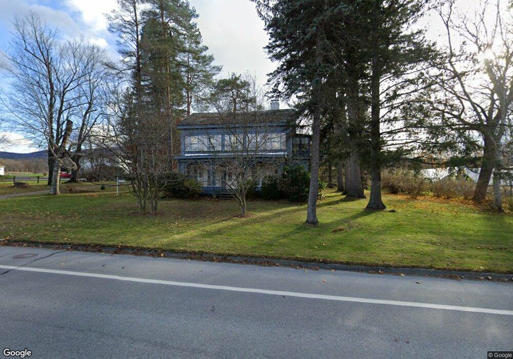
1072 State Rd North Adams, MA 01247
Estimated Value: $270,000 - $300,000
4
Beds
2
Baths
1,924
Sq Ft
$148/Sq Ft
Est. Value
About This Home
This home is located at 1072 State Rd, North Adams, MA 01247 and is currently estimated at $284,263, approximately $147 per square foot. 1072 State Rd is a home located in Berkshire County with nearby schools including Greylock Elementary School, Drury High School, and Pine Cobble School.
Ownership History
Date
Name
Owned For
Owner Type
Purchase Details
Closed on
Oct 10, 2023
Sold by
Loholdt Dolores R
Bought by
Loholdt Joseph C
Current Estimated Value
Purchase Details
Closed on
Nov 24, 2004
Sold by
Loholdt Joseph P and Loholdt Dolores R
Bought by
Loholdt Dolores R
Home Financials for this Owner
Home Financials are based on the most recent Mortgage that was taken out on this home.
Original Mortgage
$100,000
Interest Rate
5.75%
Mortgage Type
Purchase Money Mortgage
Purchase Details
Closed on
Jul 8, 1980
Bought by
Loholdt Dolores R
Create a Home Valuation Report for This Property
The Home Valuation Report is an in-depth analysis detailing your home's value as well as a comparison with similar homes in the area
Home Values in the Area
Average Home Value in this Area
Purchase History
| Date | Buyer | Sale Price | Title Company |
|---|---|---|---|
| Loholdt Joseph C | -- | None Available | |
| Loholdt Joseph C | -- | None Available | |
| Loholdt Dolores R | -- | -- | |
| Loholdt Dolores R | -- | -- | |
| Loholdt Dolores R | -- | -- | |
| Loholdt Dolores R | -- | -- |
Source: Public Records
Mortgage History
| Date | Status | Borrower | Loan Amount |
|---|---|---|---|
| Previous Owner | Loholdt Dolores R | $25,000 | |
| Previous Owner | Loholdt Dolores R | $100,000 |
Source: Public Records
Tax History Compared to Growth
Tax History
| Year | Tax Paid | Tax Assessment Tax Assessment Total Assessment is a certain percentage of the fair market value that is determined by local assessors to be the total taxable value of land and additions on the property. | Land | Improvement |
|---|---|---|---|---|
| 2025 | $4,485 | $268,400 | $39,100 | $229,300 |
| 2024 | $4,211 | $245,700 | $35,800 | $209,900 |
| 2023 | $4,110 | $232,600 | $35,800 | $196,800 |
| 2022 | $3,704 | $199,900 | $35,800 | $164,100 |
| 2021 | $3,441 | $184,900 | $33,100 | $151,800 |
| 2020 | $3,290 | $176,700 | $32,900 | $143,800 |
| 2019 | $3,144 | $164,500 | $32,900 | $131,600 |
| 2018 | $3,014 | $164,000 | $34,700 | $129,300 |
| 2017 | $2,868 | $162,300 | $34,300 | $128,000 |
| 2016 | $2,779 | $159,800 | $34,300 | $125,500 |
| 2015 | $2,687 | $161,000 | $35,500 | $125,500 |
Source: Public Records
Map
Nearby Homes
- 20 Kateley Ln
- 131 Luce Rd
- 217 Main St
- 27 Willshire Dr
- 17 Phelps Ave
- 46 Cobble View Rd
- 1 State Rd
- 14 Orchard Ln
- 0 Holly Ln
- 15 Orchard Ln
- 39 Foucher Ave
- 108 Berkshire Dr
- 5 Windflower Way
- 189 Stratton Rd Unit E2
- 189 Stratton Rd Unit E3
- 505 Barbour St
- 16 Windflower Way
- 227 Protection Ave
- 25 Taft St
- 2 River Run