Estimated Value: $237,000 - $265,000
3
Beds
1
Bath
1,554
Sq Ft
$158/Sq Ft
Est. Value
About This Home
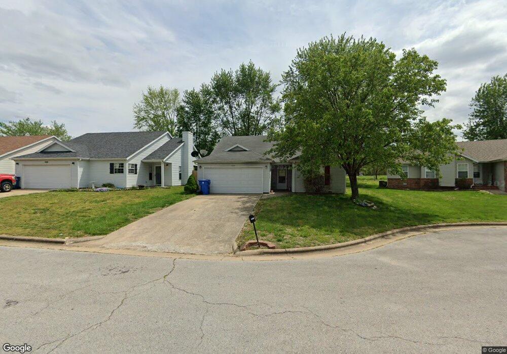
This home is located at 1072 W Green Pine Rd, Nixa, MO 65714 and is currently estimated at $245,064, approximately $157 per square foot. 1072 W Green Pine Rd is a home with nearby schools including Mathews Elementary School, Queens Gateway to Health Sciences Secondary School, and Nicholas A. Inman Intermediate School.
Ownership History
Date
Name
Owned For
Owner Type
Purchase Details
Closed on
Mar 16, 2007
Sold by
Schuler Christian S and Schuler Karrie L
Bought by
Benson Richard C and Benson Colleen M
Current Estimated Value
Home Financials for this Owner
Home Financials are based on the most recent Mortgage that was taken out on this home.
Original Mortgage
$118,500
Outstanding Balance
$71,883
Interest Rate
6.3%
Mortgage Type
New Conventional
Estimated Equity
$173,181
Purchase Details
Closed on
Jun 13, 2006
Sold by
Schuller Christian S and Schuller Karrie L
Bought by
Schuler Christian S and Schuler Karrie L
Create a Home Valuation Report for This Property
The Home Valuation Report is an in-depth analysis detailing your home's value as well as a comparison with similar homes in the area
Home Values in the Area
Average Home Value in this Area
Purchase History
| Date | Buyer | Sale Price | Title Company |
|---|---|---|---|
| Benson Richard C | -- | None Available | |
| Schuler Christian S | -- | None Available |
Source: Public Records
Mortgage History
| Date | Status | Borrower | Loan Amount |
|---|---|---|---|
| Open | Benson Richard C | $118,500 |
Source: Public Records
Tax History Compared to Growth
Tax History
| Year | Tax Paid | Tax Assessment Tax Assessment Total Assessment is a certain percentage of the fair market value that is determined by local assessors to be the total taxable value of land and additions on the property. | Land | Improvement |
|---|---|---|---|---|
| 2024 | $1,451 | $23,280 | -- | -- |
| 2023 | $1,451 | $23,280 | $0 | $0 |
| 2022 | $1,263 | $20,240 | $0 | $0 |
| 2021 | $1,264 | $20,240 | $0 | $0 |
| 2020 | $1,162 | $17,770 | $0 | $0 |
| 2019 | $1,162 | $17,770 | $0 | $0 |
| 2018 | $1,083 | $17,770 | $0 | $0 |
| 2017 | $1,083 | $17,770 | $0 | $0 |
| 2016 | $1,066 | $17,770 | $0 | $0 |
| 2015 | $1,068 | $17,770 | $17,770 | $0 |
| 2014 | $1,038 | $17,710 | $0 | $0 |
| 2013 | $10 | $17,710 | $0 | $0 |
| 2011 | $10 | $35,420 | $0 | $0 |
Source: Public Records
Map
Nearby Homes
- 701 S Cedarwood Ct
- 931 W Butterfield Dr
- 1209 W Belwood Ct
- 985 W Pembrook Ave
- 1222 W Butterfield Dr
- 975 S Pinewood Ln
- Tract 3c S Gregg Rd
- 886 W Paddington Dr
- 708 S Aurora Ct
- 955 S Silverwood Ln
- 915 S Silverwood Ln
- 911 S Silverwood Ln
- 919 S Silverwood Ln
- 965 S Silverwood Ln
- 959 S Silverwood Ln
- 951 S Silverwood Ln
- 601 S Gregg Rd
- 689 W Castor Loop
- 609 W Arbor Glenn Dr
- 621 W Arbor Glenn Dr
- 1068 Green Pine
- 1068 W Green Pine Rd
- 1074 W Green Pine Rd
- 1064 W Green Pine Rd
- 1082 W Green Pine Rd
- 1098 W Green Pine Rd
- 1075 W Green Pine Rd
- 1067 W Green Pine Rd
- 1097 W Green Pine Rd
- 1056 W Butterfield Dr
- 1056 Butterfield Dr
- 988 S Gregg Rd
- 1768 S Gregg Rd
- 807 Pin Oak
- 1048 W Butterfield Dr
- 1051 W Butterfield Dr
- 1051 Butterfield Dr
- 826 S Pin Oak
- 824 Pin Oak
- 801 S Pin Oak