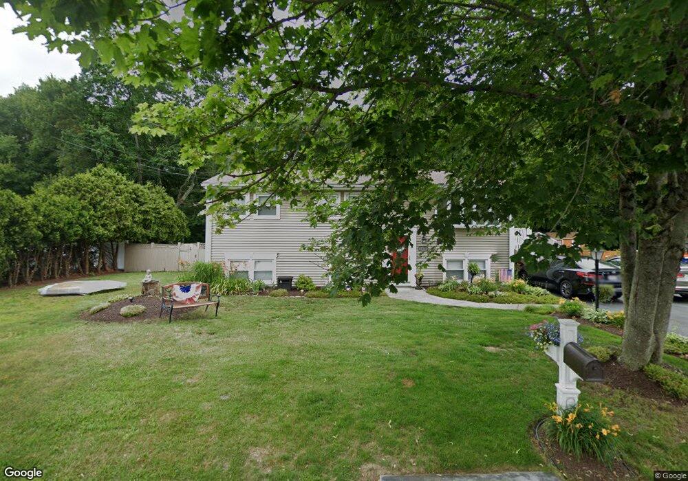
1073 Westgate St New Bedford, MA 02745
Estimated Value: $448,000 - $538,000
3
Beds
3
Baths
1,919
Sq Ft
$263/Sq Ft
Est. Value
About This Home
This home is located at 1073 Westgate St, New Bedford, MA 02745 and is currently estimated at $505,299, approximately $263 per square foot. 1073 Westgate St is a home located in Bristol County with nearby schools including Casimir Pulaski Elementary School, Normandin Middle School, and New Bedford High School.
Ownership History
Date
Name
Owned For
Owner Type
Purchase Details
Closed on
May 6, 2002
Sold by
Ferreira Wayne C
Bought by
Rebelo Richard and Rebelo Jeanne R
Current Estimated Value
Home Financials for this Owner
Home Financials are based on the most recent Mortgage that was taken out on this home.
Original Mortgage
$144,000
Interest Rate
7.13%
Mortgage Type
Purchase Money Mortgage
Create a Home Valuation Report for This Property
The Home Valuation Report is an in-depth analysis detailing your home's value as well as a comparison with similar homes in the area
Home Values in the Area
Average Home Value in this Area
Purchase History
| Date | Buyer | Sale Price | Title Company |
|---|---|---|---|
| Rebelo Richard | $180,000 | -- | |
| Rebelo Richard | $180,000 | -- |
Source: Public Records
Mortgage History
| Date | Status | Borrower | Loan Amount |
|---|---|---|---|
| Open | Rebelo Richard | $144,000 | |
| Closed | Rebelo Richard | $144,000 |
Source: Public Records
Tax History Compared to Growth
Tax History
| Year | Tax Paid | Tax Assessment Tax Assessment Total Assessment is a certain percentage of the fair market value that is determined by local assessors to be the total taxable value of land and additions on the property. | Land | Improvement |
|---|---|---|---|---|
| 2025 | $4,625 | $408,900 | $141,400 | $267,500 |
| 2024 | $4,469 | $372,400 | $153,800 | $218,600 |
| 2023 | $4,431 | $310,100 | $123,700 | $186,400 |
| 2022 | $4,177 | $268,800 | $114,900 | $153,900 |
| 2021 | $4,014 | $257,500 | $114,900 | $142,600 |
| 2020 | $3,840 | $237,600 | $114,900 | $122,700 |
| 2019 | $3,727 | $226,300 | $110,500 | $115,800 |
| 2018 | $3,587 | $215,700 | $110,500 | $105,200 |
| 2017 | $3,445 | $206,400 | $108,300 | $98,100 |
| 2016 | $3,313 | $200,900 | $106,000 | $94,900 |
| 2015 | $3,033 | $192,800 | $101,600 | $91,200 |
| 2014 | $2,873 | $189,500 | $99,400 | $90,100 |
Source: Public Records
Map
Nearby Homes
- 1063 Westgate St
- SS Charbonneau Ln
- 34 Poplar Rd
- 145 Heritage Dr
- 210 Heritage Dr
- 64 Blaze Rd
- 62 Longview Rd
- 26 Blueberry Dr
- 1069 Cherokee St
- 8 Holly Tree Ln
- 700 Pine Hill Dr
- 1269 Bartlett St
- 16 Swallow St
- 13 Luscomb Ln
- 888 Hillcrest Rd
- 12 Randall St
- 2 Woodland Rd
- 1045 Forbes St
- 1350 Phillips Rd
- ES Acushnet Ave
- 1069 Westgate St
- 1081 Westgate St
- 1070 Westgate St
- 534 Barnard St
- 1068 Westgate St
- 1059 Westgate St
- 1073 Churchill St
- 1062 Westgate St
- 526 Barnard St
- 1097 Westgate St
- 1067 Churchill St
- 535 Barnard St
- 36 Araujo Ct
- 1056 Westgate St
- 527 Barnard St
- 32 Araujo Ct
- 1047 Churchill St
- 1104 Westgate St
- 1107 Westgate St
- 1074 Churchill St