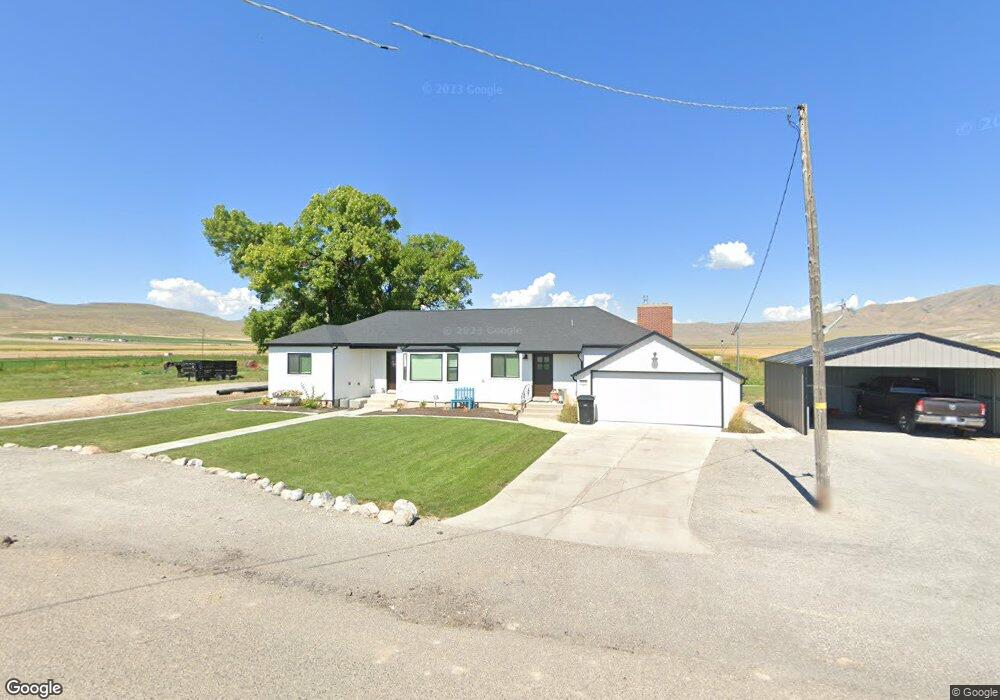
10730 W 11600 N Tremonton, UT 84337
Estimated Value: $487,000 - $754,000
4
Beds
2
Baths
2,031
Sq Ft
$286/Sq Ft
Est. Value
About This Home
This home is located at 10730 W 11600 N, Tremonton, UT 84337 and is currently estimated at $581,777, approximately $286 per square foot. 10730 W 11600 N is a home located in Box Elder County with nearby schools including Garland School, Alice C. Harris Intermediate School, and Bear River Middle School.
Ownership History
Date
Name
Owned For
Owner Type
Purchase Details
Closed on
Jan 25, 2021
Sold by
Reden Garrett and Reden Shaelee
Bought by
Rhoades Trevor F and Rhoades Ashley
Current Estimated Value
Home Financials for this Owner
Home Financials are based on the most recent Mortgage that was taken out on this home.
Original Mortgage
$286,000
Outstanding Balance
$255,352
Interest Rate
2.6%
Mortgage Type
New Conventional
Estimated Equity
$326,426
Purchase Details
Closed on
Apr 30, 2018
Sold by
Mckinney Glen L and Kckinney Melissa A
Bought by
Reden Garrett
Home Financials for this Owner
Home Financials are based on the most recent Mortgage that was taken out on this home.
Original Mortgage
$186,200
Interest Rate
4.45%
Mortgage Type
New Conventional
Purchase Details
Closed on
Feb 21, 2006
Sold by
Esplin Paige D
Bought by
Mckinney Glen L
Home Financials for this Owner
Home Financials are based on the most recent Mortgage that was taken out on this home.
Original Mortgage
$29,980
Interest Rate
6.15%
Mortgage Type
Stand Alone Second
Create a Home Valuation Report for This Property
The Home Valuation Report is an in-depth analysis detailing your home's value as well as a comparison with similar homes in the area
Home Values in the Area
Average Home Value in this Area
Purchase History
| Date | Buyer | Sale Price | Title Company |
|---|---|---|---|
| Rhoades Trevor F | -- | Mountain View Title Ogden | |
| Reden Garrett | -- | American Secure Title Tremon | |
| Mckinney Glen L | -- | None Available |
Source: Public Records
Mortgage History
| Date | Status | Borrower | Loan Amount |
|---|---|---|---|
| Open | Rhoades Trevor F | $286,000 | |
| Previous Owner | Reden Garrett | $186,200 | |
| Previous Owner | Mckinney Glen L | $29,980 |
Source: Public Records
Tax History Compared to Growth
Tax History
| Year | Tax Paid | Tax Assessment Tax Assessment Total Assessment is a certain percentage of the fair market value that is determined by local assessors to be the total taxable value of land and additions on the property. | Land | Improvement |
|---|---|---|---|---|
| 2025 | $2,264 | $440,658 | $218,600 | $222,058 |
| 2024 | $2,264 | $431,819 | $208,600 | $223,219 |
| 2023 | $2,234 | $437,629 | $199,740 | $237,889 |
| 2022 | $1,793 | $185,368 | $51,238 | $134,130 |
| 2021 | $1,778 | $251,207 | $47,150 | $204,057 |
| 2020 | $1,472 | $251,207 | $47,150 | $204,057 |
| 2019 | $0 | $0 | $0 | $0 |
Source: Public Records
Map
Nearby Homes
- 13464 N 10800 W Unit 4
- 10230 W 11200 N
- 10645 N 10800 W Unit 1
- 12695 N 10800 W
- 10205 W 10400 N
- 229 W 1470 S Unit 44
- 10959 N 8300 W
- 10973 N 8300 W Unit 24
- Stanton Plan at Marble Hills
- Xavier Plan at Marble Hills
- Somerley Plan at Marble Hills
- Northfield Plan at Marble Hills
- Norfolk Plan at Marble Hills
- Knighton Plan at Marble Hills
- Kensington Plan at Marble Hills
- Denford Plan at Marble Hills
- Edgeworth Plan at Marble Hills
- Clearpoint Plan at Marble Hills
- Canyon Plan at Marble Hills
- Cambria Plan at Marble Hills
- 10650 W 11600 N
- 11590 N 10800 W
- 10600 W 11600 N
- 11520 N 10800 W
- 11496 N 10800 W
- 10575 W 11600 N
- 11495 N 10800 W
- 11495 N 10800 W
- 10560 W 11600 N
- 11785 N 10800 W
- 10535 W 11600 N
- 11815 N 10800 W
- 10510 W 11600 N
- 12380 N Canal Bank Rd
- 11835 N 10800 W
- 11845 N 10800 W
- 11375 N 10800 W
- 11865 N 10800 W
- 16435 W 12800 N
- 11875 N 10800 W