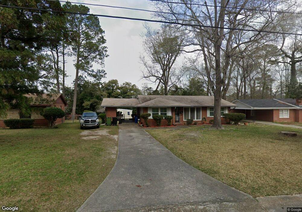
1074 Dunbar Ave Columbus, GA 31906
Lindsey Creek Park-Boxwood Estates NeighborhoodEstimated Value: $101,847 - $147,000
3
Beds
2
Baths
1,200
Sq Ft
$96/Sq Ft
Est. Value
About This Home
This home is located at 1074 Dunbar Ave, Columbus, GA 31906 and is currently estimated at $115,462, approximately $96 per square foot. 1074 Dunbar Ave is a home located in Muscogee County with nearby schools including Rigdon Road Elementary School, Richards Middle School, and Carver High School.
Ownership History
Date
Name
Owned For
Owner Type
Purchase Details
Closed on
May 2, 2025
Sold by
Robinson Lisa D and Dozier-Johnson Jada
Bought by
Robinson Lisa D and Dozier-Johnson Jada
Current Estimated Value
Purchase Details
Closed on
Oct 18, 2021
Sold by
Robinson Lisa D
Bought by
Robinson Lisa D and Dozier Johnson Jada
Purchase Details
Closed on
Apr 4, 2018
Sold by
Dozier David F
Bought by
Robinson Lisa D
Create a Home Valuation Report for This Property
The Home Valuation Report is an in-depth analysis detailing your home's value as well as a comparison with similar homes in the area
Home Values in the Area
Average Home Value in this Area
Purchase History
| Date | Buyer | Sale Price | Title Company |
|---|---|---|---|
| Robinson Lisa D | -- | None Listed On Document | |
| Robinson Lisa D | -- | None Listed On Document | |
| Robinson Lisa D | -- | -- | |
| Robinson Lisa D | -- | -- |
Source: Public Records
Tax History Compared to Growth
Tax History
| Year | Tax Paid | Tax Assessment Tax Assessment Total Assessment is a certain percentage of the fair market value that is determined by local assessors to be the total taxable value of land and additions on the property. | Land | Improvement |
|---|---|---|---|---|
| 2025 | $541 | $31,440 | $8,516 | $22,924 |
| 2024 | $539 | $31,440 | $8,516 | $22,924 |
| 2023 | $22 | $31,440 | $8,516 | $22,924 |
| 2022 | $562 | $26,992 | $8,516 | $18,476 |
| 2021 | $1,194 | $25,992 | $8,516 | $17,476 |
| 2020 | $1,062 | $25,992 | $8,516 | $17,476 |
| 2019 | $1,065 | $25,992 | $8,516 | $17,476 |
| 2018 | $1,065 | $25,992 | $8,516 | $17,476 |
| 2017 | $3,846 | $25,992 | $8,516 | $17,476 |
| 2016 | $1,043 | $25,274 | $5,520 | $19,754 |
| 2015 | $418 | $25,274 | $5,520 | $19,754 |
| 2014 | $4 | $25,274 | $5,520 | $19,754 |
| 2013 | -- | $25,274 | $5,520 | $19,754 |
Source: Public Records
Map
Nearby Homes
- 1061 Dunbar Ave
- 3122 Glenwood Dr
- 1047 Fisk Ave
- 937 Diggs Ave
- 3319 Decatur St
- 1312 Glenwood Rd
- 3570 Stratford Dr
- 2925 Colorado St
- 2902 Hood St
- 2937 Thomas St
- 1301 Rigdon Rd
- 3415 Terminal St
- 3414 Terminal St
- 2911 Thomas St
- 3413 Terminal Ct
- 776 Terminal Ct
- 2835 Thomas St
- 2833 Thomas St
- 2829 Thomas St
- 2726 Marion St
- 1080 Dunbar Ave
- 1068 Dunbar Ave
- 1087 W Lindsay Dr
- 1081 W Lindsay Dr
- 1093 W Lindsay Dr
- 1086 Dunbar Ave
- 1062 Dunbar Ave
- 1077 Dunbar Ave
- 1071 Dunbar Ave
- 1075 W Lindsay Dr
- 1099 W Lindsay Dr
- 1085 Dunbar Ave
- 1092 Dunbar Ave
- 1069 W Lindsay Dr
- 1103 W Lindsay Dr
- 1054 Dunbar Ave
- 1091 Dunbar Ave
- 3313 Glenwood Dr
- 1053 Dunbar Ave
- 1104 Dunbar Ave