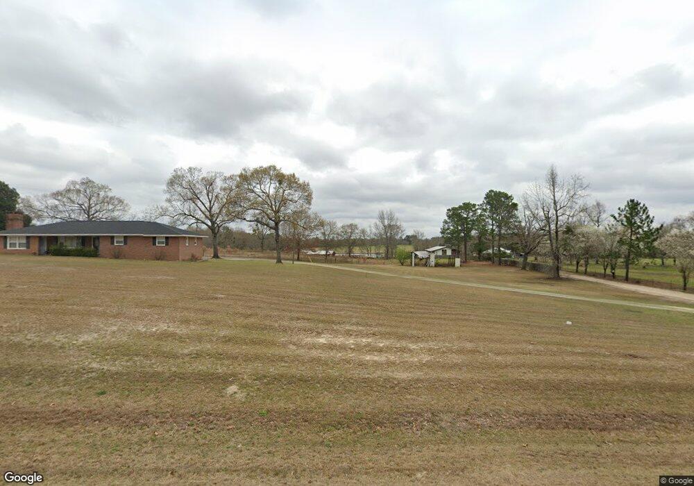
1075 Frank Cook Rd Cochran, GA 31014
Estimated Value: $242,000 - $386,000
3
Beds
2
Baths
1,805
Sq Ft
$172/Sq Ft
Est. Value
About This Home
This home is located at 1075 Frank Cook Rd, Cochran, GA 31014 and is currently estimated at $309,765, approximately $171 per square foot. 1075 Frank Cook Rd is a home located in Bleckley County with nearby schools including Bleckley County Primary School, Bleckley County Elementary School, and Bleckley Middle School.
Ownership History
Date
Name
Owned For
Owner Type
Purchase Details
Closed on
May 7, 2011
Sold by
Cranford Lynn Scarbrough
Bought by
Cranford Charles Anthony
Current Estimated Value
Purchase Details
Closed on
Dec 2, 2009
Sold by
Roland Alton E and Roland Quida M
Bought by
Scarborough Cranford Charles Anthony and Scarborough Cranford Lynn
Create a Home Valuation Report for This Property
The Home Valuation Report is an in-depth analysis detailing your home's value as well as a comparison with similar homes in the area
Home Values in the Area
Average Home Value in this Area
Purchase History
| Date | Buyer | Sale Price | Title Company |
|---|---|---|---|
| Cranford Charles Anthony | -- | -- | |
| Scarborough Cranford Charles Anthony | $162,600 | -- |
Source: Public Records
Tax History Compared to Growth
Tax History
| Year | Tax Paid | Tax Assessment Tax Assessment Total Assessment is a certain percentage of the fair market value that is determined by local assessors to be the total taxable value of land and additions on the property. | Land | Improvement |
|---|---|---|---|---|
| 2024 | $2,163 | $82,864 | $10,600 | $72,264 |
| 2023 | $1,682 | $82,864 | $10,600 | $72,264 |
| 2022 | $1,964 | $74,184 | $10,600 | $63,584 |
| 2021 | $1,577 | $56,144 | $8,480 | $47,664 |
| 2020 | $1,577 | $56,144 | $8,480 | $47,664 |
| 2019 | $972 | $35,319 | $11,393 | $23,926 |
| 2018 | $1,039 | $35,319 | $11,393 | $23,926 |
| 2017 | $979 | $35,319 | $11,393 | $23,926 |
| 2016 | $980 | $35,320 | $11,393 | $23,926 |
| 2015 | -- | $35,320 | $11,393 | $23,926 |
| 2014 | -- | $35,320 | $11,393 | $23,926 |
| 2013 | -- | $35,319 | $11,393 | $23,926 |
Source: Public Records
Map
Nearby Homes
- 205 Smith Sapp Rd
- 0 Cheek Rd
- 191 Cheek Rd
- 0 Rock Hill Rd
- 0 Jones Rd
- 319 Country Club Rd
- 178 Country Club Cir
- 176 Pineland Estates Rd
- 166 Pebble Hills Rd
- 187 Osprey Rd
- 238 Wood Oak Cir
- 288 Frank Cook Rd
- 0 Wood Oak Cir Unit 233873
- 0 Wood Oak Cir Unit 9278951
- 0 Jordan Place
- Lots Crest Dr
- LAND Crest Dr
- 762 Nicholson Carr Rd
- 150 Wood Oak Cir
- 124 Pine Hill Dr
- 1087 Frank Cook Rd
- 1067 Frank Cook Rd
- 1042 Frank Cook Rd
- 1010 Frank Cook Rd
- 965 Frank Cook Rd
- 262 Herman Floyd Rd
- 179 Bass Rd
- 3856 Roddy Hwy
- 268 Herman Floyd Rd
- 239 Herman Floyd Rd
- 272 Herman Floyd Rd
- 1877 W Chicken Rd
- 183 Herman Floyd Rd
- 283 Roddy Rd
- 253 Roddy Rd
- 294 Herman Floyd Rd
- 3810 Roddy Hwy
- 299 Roddy Rd
- 277 Roddy Rd
- 314 Bass Mullis Smith Rd