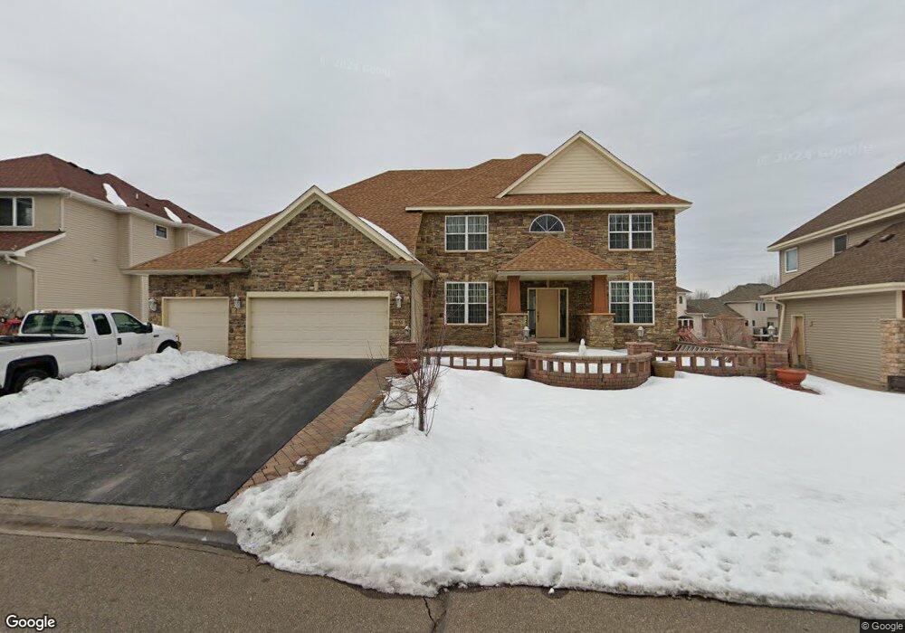
10750 Mccool Dr E Burnsville, MN 55337
Estimated Value: $600,905 - $667,000
5
Beds
4
Baths
3,993
Sq Ft
$157/Sq Ft
Est. Value
About This Home
This home is located at 10750 Mccool Dr E, Burnsville, MN 55337 and is currently estimated at $628,476, approximately $157 per square foot. 10750 Mccool Dr E is a home located in Dakota County with nearby schools including Burnsville High School, Gateway STEM Academy, and Sunrise International Montessori School.
Ownership History
Date
Name
Owned For
Owner Type
Purchase Details
Closed on
Nov 12, 2009
Sold by
Us Bank Nat Assoc
Bought by
Dao Kiem and Hoang Tina
Current Estimated Value
Purchase Details
Closed on
Dec 1, 2005
Sold by
Mcdevitt Homes Inc
Bought by
Malone Jacqueline
Purchase Details
Closed on
Apr 29, 2004
Sold by
Manley Land Development Inc
Bought by
Mcdevit Homes Inc
Create a Home Valuation Report for This Property
The Home Valuation Report is an in-depth analysis detailing your home's value as well as a comparison with similar homes in the area
Home Values in the Area
Average Home Value in this Area
Purchase History
| Date | Buyer | Sale Price | Title Company |
|---|---|---|---|
| Dao Kiem | $340,000 | -- | |
| Malone Jacqueline | $620,802 | -- | |
| Mcdevit Homes Inc | $799,500 | -- |
Source: Public Records
Tax History
| Year | Tax Paid | Tax Assessment Tax Assessment Total Assessment is a certain percentage of the fair market value that is determined by local assessors to be the total taxable value of land and additions on the property. | Land | Improvement |
|---|---|---|---|---|
| 2024 | $6,206 | $578,400 | $157,300 | $421,100 |
| 2023 | $6,174 | $571,800 | $157,500 | $414,300 |
| 2022 | $5,366 | $562,500 | $157,100 | $405,400 |
| 2021 | $5,226 | $495,700 | $136,600 | $359,100 |
| 2020 | $5,468 | $457,400 | $130,100 | $327,300 |
| 2019 | $5,455 | $460,900 | $123,900 | $337,000 |
| 2018 | $5,619 | $436,400 | $118,000 | $318,400 |
| 2017 | $5,276 | $436,000 | $112,300 | $323,700 |
| 2016 | $4,884 | $402,000 | $107,000 | $295,000 |
| 2015 | $4,610 | $355,487 | $102,512 | $252,975 |
| 2014 | -- | $350,582 | $100,504 | $250,078 |
| 2013 | -- | $331,071 | $91,512 | $239,559 |
Source: Public Records
Map
Nearby Homes
- 3321 Willie Dr
- 2216 Water Lilly Ln Unit 607
- 2232 White Water Way
- 2122 Water Lilly Ln Unit 1206
- 10716 27th Ave S
- 11036 27th Ave S
- 11205 River Hills Dr
- 4354 Metcalf Dr
- 4022 Cedar Grove Ln
- 3981 Cedar Grove Ln
- 2082 Diffley Rd
- 3976 Cedar Grove Ln
- 2078 Diffley Rd
- 4004 Cedar Grove Ln
- 4002 Cedar Grove Ln
- 2002 Diffley Rd
- 3902 Rahn Rd
- 3904 Rahn Rd
- 2006 E 115th St
- 4110 Rahn Rd Unit 201
- 10730 Mccool Dr E
- 10760 Mccool Dr E
- 10760 10760 McCool-drive-e
- 10757 Mccool Dr W
- 10721 Mccool Dr W
- 10712 Mccool Dr E
- 10755 Mccool Dr E
- 10755 10755 McCool-drive-e
- 10735 Mccool Dr E
- 10784 Mccool Dr E
- 10771 Mccool Dr W
- 10779 Mccool Dr E
- 10717 Mccool Dr E
- 10707 Mccool Dr W
- 10690 Mccool Dr E
- 3350 Willie Dr
- 10705 Mccool Dr E
- 10705 10705 McCool-drive-e
- 10748 Mccool Dr W
- 10732 Mccool Dr W
Your Personal Tour Guide
Ask me questions while you tour the home.