
Seller's Agent in 2017
Rusty Kiko
Kiko
(330) 495-0923
363 Total Sales


Estimated Value: $279,000
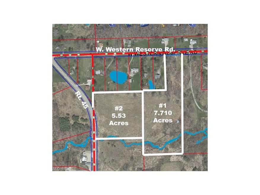
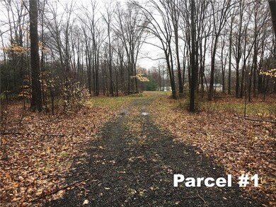
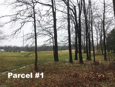
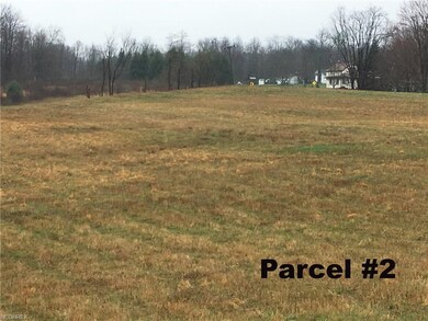
Two Beautiful Building Tracts - Both Adjoining – 7.71 Acres & 5.53 Acres - Green Twp. – South Range Schools – 10 Minutes To School, Salem, & Canfield. Owners are relocating and will sell at ABSOLUTE AUCTION, all sells to the highest bidder on location: MONDAY - MAY 1, 2017 – 6:00 PM - Parcel #1 – 7.710 acres land – private wooded driveway already installed along with new septic system. Open field in rear plus large oak trees with scenic view overlooking valley with Meandor Creek – you’ll love this one. Build your own home. Parcel #2 – 5.53 acres – adjoins parcel #1 – fronts on Rt. 45 – mostly all open land – lays real nice. Great view. Buy one or both. Mineral rights transfer – CAUV taxes – map on website or in mailbox at site. TERMS ON REAL ESTATE: 10% down auction day, balance due at closing. A 10% buyer’s premium will be added to the highest bid to establish the purchase price, which goes to the seller. Any desired inspections must be made prior to bidding. All information contained herein was derived from sources believed to be correct. Information is believed to be accurate but not guaranteed.
| Date | Buyer | Sale Price | Title Company |
|---|---|---|---|
| Burr John D | $53,261 | -- | |
| Lasky Reva | -- | -- |
| Date | Event | Price | Change | Sq Ft Price |
|---|---|---|---|---|
| 06/13/2017 06/13/17 | Sold | $107,250 | 0.0% | -- |
| 05/01/2017 05/01/17 | Pending | -- | -- | -- |
| 04/12/2017 04/12/17 | For Sale | $107,250 | -- | -- |
| Year | Tax Paid | Tax Assessment Tax Assessment Total Assessment is a certain percentage of the fair market value that is determined by local assessors to be the total taxable value of land and additions on the property. | Land | Improvement |
|---|---|---|---|---|
| 2024 | $248 | $25,250 | $25,250 | -- |
| 2023 | $249 | $5,270 | $5,270 | $0 |
| 2022 | $108 | $22,170 | $22,170 | $0 |
| 2021 | $106 | $22,170 | $22,170 | $0 |
| 2020 | $106 | $22,170 | $22,170 | $0 |
| 2019 | $229 | $22,170 | $22,170 | $0 |
| 2018 | $230 | $22,170 | $22,170 | $0 |
| 2017 | $230 | $22,170 | $22,170 | $0 |
| 2016 | $346 | $21,900 | $21,900 | $0 |
| 2015 | $334 | $21,900 | $21,900 | $0 |
| 2014 | $341 | $21,900 | $21,900 | $0 |
| 2013 | $133 | $21,900 | $21,900 | $0 |
Seller's Agent in 2017
Rusty Kiko
Kiko
(330) 495-0923
363 Total Sales
Source: MLS Now
MLS Number: 3893601
APN: 09-008-0-008.00-0
Disclaimer: Certain information contained herein is derived from information provided by parties other than Homes.com. All information provided is deemed reliable, but is not guaranteed to be accurate and should be independently verified.
![]() IDX information is provided exclusively for personal, non-commercial use, and may not be used for any purpose other than to identify prospective properties consumers may be interested in purchasing. Information is deemed reliable but not guaranteed.
IDX information is provided exclusively for personal, non-commercial use, and may not be used for any purpose other than to identify prospective properties consumers may be interested in purchasing. Information is deemed reliable but not guaranteed.