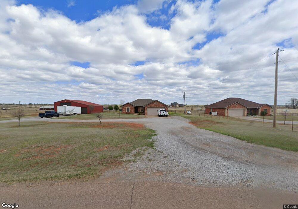
10786 N 1990 Rd Elk City, OK 73644
Estimated Value: $269,803 - $353,000
3
Beds
2
Baths
1,667
Sq Ft
$187/Sq Ft
Est. Value
About This Home
This home is located at 10786 N 1990 Rd, Elk City, OK 73644 and is currently estimated at $312,451, approximately $187 per square foot. 10786 N 1990 Rd is a home located in Beckham County with nearby schools including Merritt Elementary School and Merritt High School.
Ownership History
Date
Name
Owned For
Owner Type
Purchase Details
Closed on
Dec 6, 2023
Sold by
Roger Kevin Cates Revocable Trust
Bought by
Ferrari Daniel
Current Estimated Value
Purchase Details
Closed on
Feb 13, 2019
Sold by
Wilson Blake and Wilson Taylor
Bought by
Lucas Vincent Thomas and Lucas Melissa Ashley
Home Financials for this Owner
Home Financials are based on the most recent Mortgage that was taken out on this home.
Original Mortgage
$242,250
Interest Rate
4.5%
Mortgage Type
New Conventional
Purchase Details
Closed on
Jul 16, 2014
Sold by
Chris
Bought by
Blake
Purchase Details
Closed on
Jun 23, 2011
Sold by
Barnes Chris and Barnes Andrea
Bought by
Barnes Chris and Barnes Andrea
Purchase Details
Closed on
May 20, 2011
Sold by
Lippencott
Bought by
Barnes Chris
Purchase Details
Closed on
May 6, 2008
Sold by
Culver Damon and Culver Candida
Bought by
Lippencott Coby
Create a Home Valuation Report for This Property
The Home Valuation Report is an in-depth analysis detailing your home's value as well as a comparison with similar homes in the area
Home Values in the Area
Average Home Value in this Area
Purchase History
| Date | Buyer | Sale Price | Title Company |
|---|---|---|---|
| Ferrari Daniel | $230,000 | None Listed On Document | |
| Lucas Vincent Thomas | $255,000 | Smith Title & Closing Llc | |
| Blake | $230,000 | -- | |
| Barnes Chris | -- | None Available | |
| Barnes Chris | $205,000 | -- | |
| Lippencott Coby | $15,000 | None Available |
Source: Public Records
Mortgage History
| Date | Status | Borrower | Loan Amount |
|---|---|---|---|
| Previous Owner | Lucas Vincent Thomas | $242,250 |
Source: Public Records
Tax History Compared to Growth
Tax History
| Year | Tax Paid | Tax Assessment Tax Assessment Total Assessment is a certain percentage of the fair market value that is determined by local assessors to be the total taxable value of land and additions on the property. | Land | Improvement |
|---|---|---|---|---|
| 2025 | $2,821 | $28,851 | $1,172 | $27,679 |
| 2024 | $2,821 | $28,827 | $1,172 | $27,655 |
| 2023 | $2,821 | $28,827 | $1,172 | $27,655 |
| 2022 | $2,811 | $29,068 | $1,070 | $27,998 |
| 2021 | $2,985 | $29,935 | $2,124 | $27,811 |
| 2020 | $2,964 | $30,405 | $2,124 | $28,281 |
| 2019 | $2,657 | $28,111 | $1,062 | $27,049 |
| 2018 | $2,705 | $28,111 | $1,062 | $27,049 |
| 2017 | $2,610 | $27,600 | $616 | $26,984 |
| 2016 | $2,565 | $27,600 | $616 | $26,984 |
| 2015 | $2,198 | $27,600 | $616 | $26,984 |
| 2014 | $1,886 | $24,600 | $616 | $23,984 |
Source: Public Records
Map
Nearby Homes
- 0000 N 283 Hwy
- 19108 E 1080 Rd
- 1410 Easy St
- 311 Peggy Dr
- 304 Beth Ln
- 110 Peggy Dr
- 1701 W Country Club Blvd
- 0 N 1970 Rd Unit 1125586
- 0 N 1970 Rd Unit 1125390
- 1409 Dalton Ave
- 1407 Dalton Ave
- 909 N Peace Ave
- 220 Hoover Cir
- 1523 N Washington Ave
- 904 Kathys Place
- 2304 Bell Ave
- 0 1960 Rd Unit 1061791
- 210 Hoover Cir
- 1304 Lynnwood Dr
- 805 Shore Dr
- 10788 N 1990 Rd
- 10784 N 1990 Rd
- 10794 N 1990 Rd
- 10736 N 1990 Rd
- 10791 N 1990 Rd
- 10781 N 1990 Rd
- 19923 E 1080 Rd
- 10762 N 1990 Rd
- 10764 N 1990 Rd
- 10761 N 1990 Rd
- 10759 N 1990 Rd
- 10748 N 1990 Rd
- 10824 N 1990 Rd
- 10744 N 1990 Rd
- 19920 E 1070 Rd
- 19918 E 1070 Rd
- 10681 N 1990 Rd
- 10683 N 1990 Rd
- 10793 N 2000 Rd
- 10693 N 1990 Rd