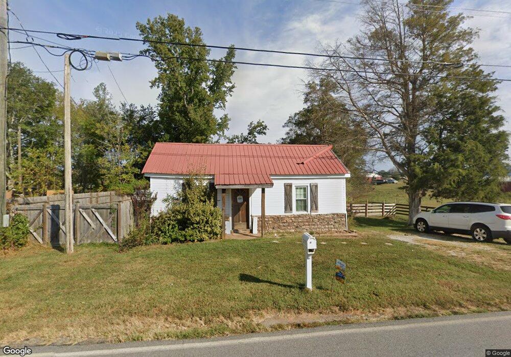
1079 Farmers High Rd Carrollton, GA 30117
Estimated Value: $195,000 - $208,000
2
Beds
1
Bath
765
Sq Ft
$261/Sq Ft
Est. Value
About This Home
This home is located at 1079 Farmers High Rd, Carrollton, GA 30117 and is currently estimated at $199,771, approximately $261 per square foot. 1079 Farmers High Rd is a home located in Carroll County with nearby schools including Bowdon Elementary School, Bowdon Middle School, and Bowdon High School.
Ownership History
Date
Name
Owned For
Owner Type
Purchase Details
Closed on
Aug 23, 2021
Sold by
Powell Brian Keith
Bought by
Powell Brian Keith and Powell Barbara Sue
Current Estimated Value
Home Financials for this Owner
Home Financials are based on the most recent Mortgage that was taken out on this home.
Original Mortgage
$150,228
Outstanding Balance
$136,190
Interest Rate
2.7%
Mortgage Type
FHA
Estimated Equity
$63,581
Purchase Details
Closed on
Apr 22, 2009
Sold by
Lackey Norman J
Bought by
Argyllshire Development Grp Ll
Purchase Details
Closed on
Nov 9, 2001
Sold by
Lakcey Norman J
Bought by
Lackey Norman J
Purchase Details
Closed on
Sep 21, 2001
Sold by
Cox Clarice S
Bought by
Lakcey Norman J
Create a Home Valuation Report for This Property
The Home Valuation Report is an in-depth analysis detailing your home's value as well as a comparison with similar homes in the area
Home Values in the Area
Average Home Value in this Area
Purchase History
| Date | Buyer | Sale Price | Title Company |
|---|---|---|---|
| Powell Brian Keith | -- | -- | |
| Powell Brian Keith | $153,000 | -- | |
| Lackey Norman | -- | -- | |
| Argyllshire Development Grp Ll | -- | -- | |
| Lackey Norman J | -- | -- | |
| Lakcey Norman J | $5,000 | -- |
Source: Public Records
Mortgage History
| Date | Status | Borrower | Loan Amount |
|---|---|---|---|
| Open | Lackey Norman | $150,228 | |
| Closed | Powell Brian Keith | $150,228 |
Source: Public Records
Tax History Compared to Growth
Tax History
| Year | Tax Paid | Tax Assessment Tax Assessment Total Assessment is a certain percentage of the fair market value that is determined by local assessors to be the total taxable value of land and additions on the property. | Land | Improvement |
|---|---|---|---|---|
| 2024 | $348 | $15,380 | $2,819 | $12,561 |
| 2023 | $348 | $13,736 | $2,256 | $11,480 |
| 2022 | $271 | $10,798 | $1,504 | $9,294 |
| 2021 | $237 | $9,249 | $1,203 | $8,046 |
| 2020 | $210 | $8,192 | $1,094 | $7,098 |
| 2019 | $201 | $7,779 | $1,094 | $6,685 |
| 2018 | $187 | $7,126 | $1,094 | $6,032 |
| 2017 | $188 | $7,126 | $1,094 | $6,032 |
| 2016 | $138 | $6,168 | $1,094 | $5,074 |
| 2015 | $80 | $2,865 | $737 | $2,128 |
| 2014 | $80 | $2,865 | $737 | $2,128 |
Source: Public Records
Map
Nearby Homes
- 1100 Farmers High Rd
- 1055 Farmers High Rd
- 1129 Farmers High Rd
- 1184 Farmers High Rd
- 1184 Farmers High Rd
- 1248 Farmers High Rd
- 1276 Farmers High Rd
- 149 Brock Rd
- 180 Brock Rd
- 1289 Farmers High Rd
- 151 Lee Morgan Rd
- 848 Farmers High Rd
- 320 Harman Ln
- 1332 Farmers High Rd
- 1318 Farmers High Rd
- 1345 Farmers High Rd
- 288 Harman Ln
- 1377 Farmers High Rd
- 236 Harman Ln
- 309 Brock Rd