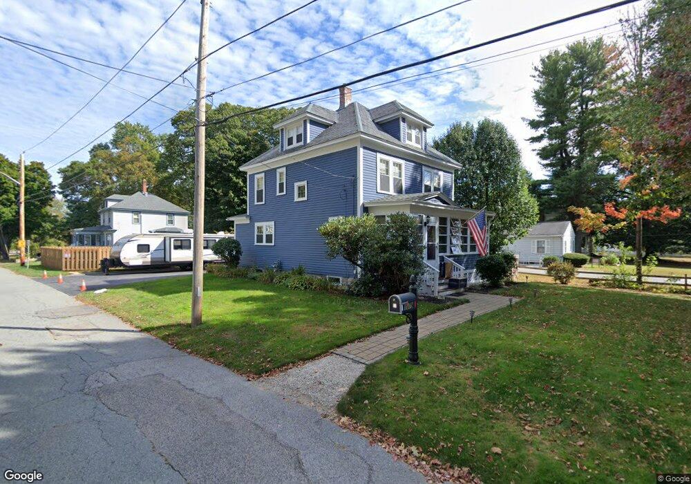
1079 Main St Leominster, MA 01453
Estimated Value: $485,000 - $563,000
3
Beds
2
Baths
1,615
Sq Ft
$320/Sq Ft
Est. Value
About This Home
This home is located at 1079 Main St, Leominster, MA 01453 and is currently estimated at $517,400, approximately $320 per square foot. 1079 Main St is a home located in Worcester County with nearby schools including Leominster High School, St Bernards Elementary School, and St. Leo School.
Ownership History
Date
Name
Owned For
Owner Type
Purchase Details
Closed on
Apr 29, 2011
Sold by
Boyle Barbara J and Belliveau Ann E
Bought by
Krivi Justin D
Current Estimated Value
Home Financials for this Owner
Home Financials are based on the most recent Mortgage that was taken out on this home.
Original Mortgage
$161,500
Outstanding Balance
$111,613
Interest Rate
4.76%
Mortgage Type
Purchase Money Mortgage
Estimated Equity
$405,787
Purchase Details
Closed on
Aug 18, 2008
Sold by
Boyle Mary A
Bought by
Boyle Mark S and Belliveau Ann E
Create a Home Valuation Report for This Property
The Home Valuation Report is an in-depth analysis detailing your home's value as well as a comparison with similar homes in the area
Home Values in the Area
Average Home Value in this Area
Purchase History
| Date | Buyer | Sale Price | Title Company |
|---|---|---|---|
| Krivi Justin D | $190,000 | -- | |
| Boyle Mark S | -- | -- |
Source: Public Records
Mortgage History
| Date | Status | Borrower | Loan Amount |
|---|---|---|---|
| Open | Krivi Justin D | $161,500 |
Source: Public Records
Tax History Compared to Growth
Tax History
| Year | Tax Paid | Tax Assessment Tax Assessment Total Assessment is a certain percentage of the fair market value that is determined by local assessors to be the total taxable value of land and additions on the property. | Land | Improvement |
|---|---|---|---|---|
| 2025 | $6,476 | $461,600 | $127,200 | $334,400 |
| 2024 | $6,344 | $437,200 | $121,200 | $316,000 |
| 2023 | $6,005 | $386,400 | $105,400 | $281,000 |
| 2022 | $5,728 | $345,900 | $91,600 | $254,300 |
| 2021 | $0 | $297,900 | $71,400 | $226,500 |
| 2020 | $5,624 | $312,800 | $71,400 | $241,400 |
| 2019 | $5,384 | $290,400 | $68,000 | $222,400 |
| 2018 | $0 | $248,300 | $66,000 | $182,300 |
| 2017 | $4,690 | $237,700 | $61,700 | $176,000 |
| 2016 | $4,366 | $223,000 | $61,700 | $161,300 |
| 2015 | $4,170 | $214,500 | $61,700 | $152,800 |
| 2014 | $3,897 | $206,300 | $68,000 | $138,300 |
Source: Public Records
Map
Nearby Homes
- 1084 Main St
- 32 Fox Meadow Rd Unit E
- 55 Fox Meadow Rd Unit H
- 17 Fernwood Dr Unit G
- 36 Fox Meadow Rd Unit A
- 17 Fernwood Dr Unit D
- 51 Fox Meadow Rd Unit C
- 48 Fox Meadow Rd Unit G
- 291 Joslin St
- 40 Flaggler Rd
- 24 Causeway Terrace
- 24 North St
- 313 Lincoln St
- 11 Dale Ave
- 4 Lincoln St
- 75 Dale Ave
- 1479 Main St
- 59 Kenniston St
- 57 Liberty St Unit 2
- 29 Crawford St