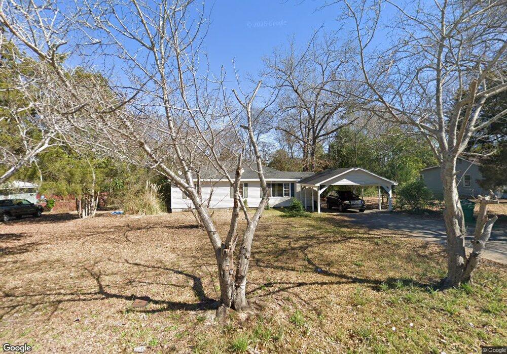
108 Fisher St Warner Robins, GA 31093
Estimated Value: $120,000 - $151,000
4
Beds
2
Baths
1,396
Sq Ft
$102/Sq Ft
Est. Value
About This Home
This home is located at 108 Fisher St, Warner Robins, GA 31093 and is currently estimated at $142,963, approximately $102 per square foot. 108 Fisher St is a home located in Houston County with nearby schools including Westside Elementary School, Northside Middle School, and Northside High School.
Ownership History
Date
Name
Owned For
Owner Type
Purchase Details
Closed on
Jun 9, 2022
Sold by
Annice Kibler Miriam
Bought by
Kibler Living Trust
Current Estimated Value
Purchase Details
Closed on
Jun 18, 2017
Sold by
Harper Charles Dwing and Harper Angela Kay
Bought by
Kibler Michael David and Kibler Miriam Annie
Purchase Details
Closed on
Apr 12, 1993
Sold by
Mcmahan Donald E and Sue Ann*
Bought by
Harper Charles D and Harper Angela*
Purchase Details
Closed on
Dec 1, 1978
Sold by
Gruber Jerry D and Gruber Brenda A
Bought by
Mcmahan Donald E and Sue Ann*
Purchase Details
Closed on
Jan 17, 1978
Sold by
Glasgow Carol A and Glasgow Douglas A
Bought by
Gruber Jerry D and Gruber Brenda A
Purchase Details
Closed on
Dec 5, 1975
Sold by
Brantley Carol Ann
Bought by
Glasgow Carol A and Glasgow Douglas A
Purchase Details
Closed on
Mar 29, 1973
Sold by
Lowder William H
Bought by
Brantley Carol Ann
Purchase Details
Closed on
Jun 6, 1972
Sold by
Studstill Mattie
Bought by
Lowder William H
Create a Home Valuation Report for This Property
The Home Valuation Report is an in-depth analysis detailing your home's value as well as a comparison with similar homes in the area
Home Values in the Area
Average Home Value in this Area
Purchase History
| Date | Buyer | Sale Price | Title Company |
|---|---|---|---|
| Kibler Living Trust | -- | None Listed On Document | |
| Kibler Michael David | $54,000 | None Available | |
| Harper Charles D | $28,000 | -- | |
| Mcmahan Donald E | -- | -- | |
| Gruber Jerry D | -- | -- | |
| Glasgow Carol A | -- | -- | |
| Brantley Carol Ann | -- | -- | |
| Lowder William H | -- | -- |
Source: Public Records
Tax History Compared to Growth
Tax History
| Year | Tax Paid | Tax Assessment Tax Assessment Total Assessment is a certain percentage of the fair market value that is determined by local assessors to be the total taxable value of land and additions on the property. | Land | Improvement |
|---|---|---|---|---|
| 2024 | $829 | $34,640 | $5,560 | $29,080 |
| 2023 | $699 | $28,920 | $3,600 | $25,320 |
| 2022 | $639 | $26,440 | $3,600 | $22,840 |
| 2021 | $586 | $24,120 | $3,600 | $20,520 |
| 2020 | $596 | $24,400 | $3,600 | $20,800 |
| 2019 | $596 | $24,400 | $3,600 | $20,800 |
| 2018 | $596 | $24,400 | $3,600 | $20,800 |
| 2017 | $596 | $24,400 | $3,600 | $20,800 |
| 2016 | $597 | $24,400 | $3,600 | $20,800 |
| 2015 | $598 | $24,400 | $3,600 | $20,800 |
| 2014 | -- | $24,400 | $3,600 | $20,800 |
| 2013 | -- | $25,040 | $4,000 | $21,040 |
Source: Public Records
Map
Nearby Homes
- 209 Knodishall Dr
- 129 Maryjay Dr
- 111 Hawthorne Rd
- 501 Pinecrest Dr
- 301 Millside Dr
- 318 Somerset Dr
- 112 Peacock Dr
- 321 Somerset Dr
- 127 N Amanda Place
- 106 Westcliff Cir
- 110 Westcliff Cir Unit C
- 103 Westcliff Cir Unit A
- 103 Westcliff Cir Unit A
- 725 B East Side Dr
- 221 Gilchrist Dr
- 303 Pinecrest Dr
- 707 Wilmington Dr
- 141 Peacock Dr
- 115 Pershing Place Ct
- 86 Westcliff Cir