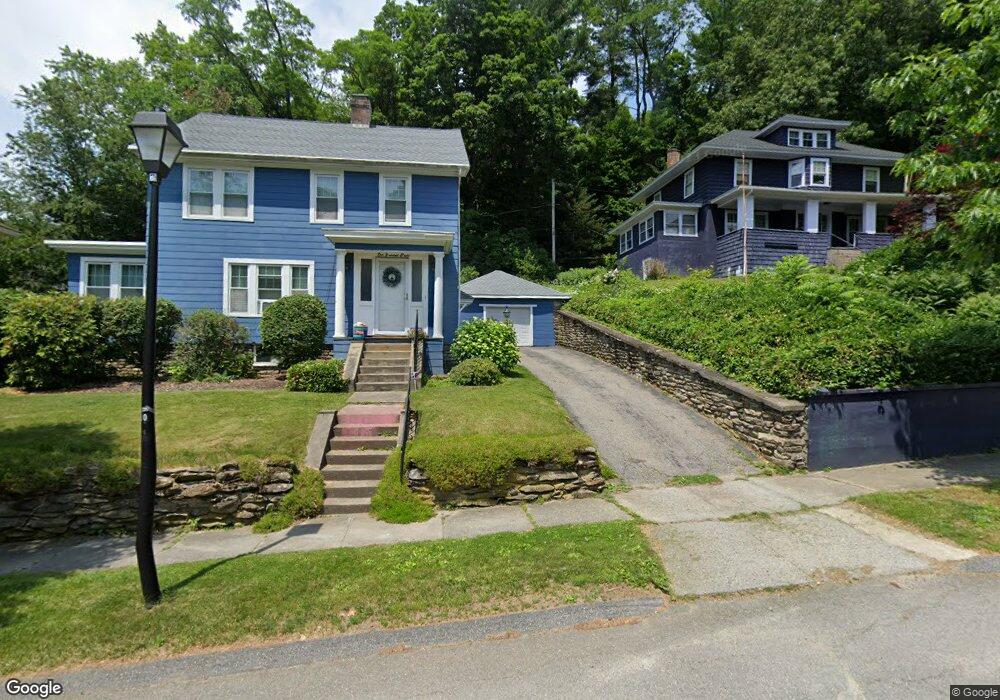
108 Morningside Rd Worcester, MA 01602
Newton Square NeighborhoodEstimated Value: $459,000 - $488,000
5
Beds
2
Baths
1,853
Sq Ft
$255/Sq Ft
Est. Value
About This Home
This home is located at 108 Morningside Rd, Worcester, MA 01602 and is currently estimated at $472,645, approximately $255 per square foot. 108 Morningside Rd is a home located in Worcester County with nearby schools including Chandler Magnet, Jacob Hiatt Magnet School, and May Street Elementary School.
Ownership History
Date
Name
Owned For
Owner Type
Purchase Details
Closed on
Jun 24, 2014
Sold by
Beauregard Mildred A
Bought by
Bissell Emily E
Current Estimated Value
Home Financials for this Owner
Home Financials are based on the most recent Mortgage that was taken out on this home.
Original Mortgage
$180,500
Outstanding Balance
$137,344
Interest Rate
4.21%
Mortgage Type
New Conventional
Estimated Equity
$335,301
Create a Home Valuation Report for This Property
The Home Valuation Report is an in-depth analysis detailing your home's value as well as a comparison with similar homes in the area
Home Values in the Area
Average Home Value in this Area
Purchase History
| Date | Buyer | Sale Price | Title Company |
|---|---|---|---|
| Bissell Emily E | $190,000 | -- |
Source: Public Records
Mortgage History
| Date | Status | Borrower | Loan Amount |
|---|---|---|---|
| Open | Bissell Emily E | $180,500 |
Source: Public Records
Tax History
| Year | Tax Paid | Tax Assessment Tax Assessment Total Assessment is a certain percentage of the fair market value that is determined by local assessors to be the total taxable value of land and additions on the property. | Land | Improvement |
|---|---|---|---|---|
| 2025 | $5,008 | $379,700 | $117,800 | $261,900 |
| 2024 | $4,818 | $350,400 | $117,800 | $232,600 |
| 2023 | $4,632 | $323,000 | $102,400 | $220,600 |
| 2022 | $4,279 | $281,300 | $82,000 | $199,300 |
| 2021 | $4,272 | $262,400 | $65,500 | $196,900 |
| 2020 | $4,087 | $240,400 | $65,600 | $174,800 |
| 2019 | $3,942 | $219,000 | $59,000 | $160,000 |
| 2018 | $3,948 | $208,800 | $59,000 | $149,800 |
| 2017 | $3,794 | $197,400 | $59,000 | $138,400 |
| 2016 | $3,761 | $182,500 | $42,900 | $139,600 |
| 2015 | $3,663 | $182,500 | $42,900 | $139,600 |
| 2014 | $3,634 | $186,000 | $42,900 | $143,100 |
Source: Public Records
Map
Nearby Homes
- 102 Morningside Rd
- 112 Morningside Rd
- 8 Rob Roy Rd
- 114 Morningside Rd
- 100 Morningside Rd
- 105 Morningside Rd
- 109 Morningside Rd
- 12 Rob Roy Rd
- 101 Morningside Rd
- 113 Morningside Rd
- 97 Morningside Rd
- 16 Rob Roy Rd
- 98 Morningside Rd
- 117 Morningside Rd
- 117 Morningside Rd Unit Left
- 117 Morningside Rd Unit Right
- 122 Morningside Rd
- 93 Morningside Rd
- 22 Rob Roy Rd
- 11 Herbert Rd
Your Personal Tour Guide
Ask me questions while you tour the home.