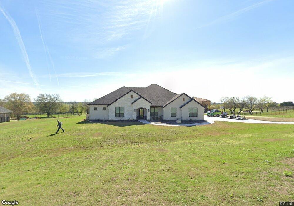
108 Top Flight Dr Weatherford, TX 76087
Estimated Value: $473,081 - $856,000
--
Bed
--
Bath
3,147
Sq Ft
$213/Sq Ft
Est. Value
About This Home
This home is located at 108 Top Flight Dr, Weatherford, TX 76087 and is currently estimated at $668,770, approximately $212 per square foot. 108 Top Flight Dr is a home located in Parker County with nearby schools including Brock Intermediate School, Brock Junior High School, and Brock High School.
Ownership History
Date
Name
Owned For
Owner Type
Purchase Details
Closed on
Sep 30, 2020
Sold by
Building Innovations Group 1 Lp
Bought by
Beard Kirk Wesley and Beard Brenda Jean
Current Estimated Value
Purchase Details
Closed on
Oct 4, 2006
Sold by
Grant Ted
Bought by
Building Innovations Group I Lp
Purchase Details
Closed on
Oct 31, 2003
Sold by
Mahan Place Ltd
Bought by
Building Innovations Group I Lp
Purchase Details
Closed on
Oct 27, 2003
Sold by
Graham Hart Ltd
Bought by
Building Innovations Group I Lp
Purchase Details
Closed on
Jan 20, 2003
Sold by
Canyon West Development Co Ltd
Bought by
Building Innovations Group I Lp
Purchase Details
Closed on
Aug 7, 2001
Sold by
Mickle Wesley J
Bought by
Building Innovations Group I Lp
Create a Home Valuation Report for This Property
The Home Valuation Report is an in-depth analysis detailing your home's value as well as a comparison with similar homes in the area
Home Values in the Area
Average Home Value in this Area
Purchase History
| Date | Buyer | Sale Price | Title Company |
|---|---|---|---|
| Beard Kirk Wesley | -- | Providence Title Company | |
| Building Innovations Group I Lp | -- | -- | |
| Building Innovations Group I Lp | -- | -- | |
| Building Innovations Group I Lp | -- | -- | |
| Building Innovations Group I Lp | -- | -- | |
| Building Innovations Group I Lp | -- | -- |
Source: Public Records
Tax History Compared to Growth
Tax History
| Year | Tax Paid | Tax Assessment Tax Assessment Total Assessment is a certain percentage of the fair market value that is determined by local assessors to be the total taxable value of land and additions on the property. | Land | Improvement |
|---|---|---|---|---|
| 2025 | $7,439 | $467,470 | $62,500 | $404,970 |
| 2024 | $7,439 | $444,160 | $62,500 | $381,660 |
| 2023 | $7,439 | $444,160 | $62,500 | $381,660 |
| 2022 | $10,862 | $535,010 | $65,000 | $470,010 |
| 2021 | $1,388 | $65,000 | $65,000 | $0 |
| 2020 | $1,082 | $50,000 | $50,000 | $0 |
| 2019 | $1,165 | $50,000 | $50,000 | $0 |
| 2018 | $585 | $25,000 | $25,000 | $0 |
| 2017 | $575 | $25,000 | $25,000 | $0 |
| 2016 | $575 | $25,000 | $25,000 | $0 |
| 2015 | $568 | $25,000 | $25,000 | $0 |
| 2014 | $574 | $25,000 | $25,000 | $0 |
Source: Public Records
Map
Nearby Homes
- 113 Laser Ln
- 234 Trail Ridge
- 150 Top Flight Dr
- 123 Club House Dr
- 162 Pinnacle Peak Ln
- 125 Summer Stone Ct
- 1060 Kessler Rd
- 197 Pinnacle Peak Ln
- 101 Trail Ridge
- 205 Pinnacle Peak Ln
- 120 Trail Ridge
- 0 Quanah Hill Rd Unit 23872058
- 313 Canyon Creek Cir
- 873 Canyon Creek Ln
- 393 Canyon Creek Cir
- 788 W Canyon Creek Ln
- TBA Old Brock Rd
- 833 N Savage Creek Ln
- 151 Canyon Creek Ct
- 673 E Canyon Creek Ln
- 114 Top Flight Dr
- 102 Top Flight Dr
- 104 Top Flight Dr
- 101 Laser Ln
- L2B4 Laser Ln
- 117 Top Flight Dr
- 122 Top Flight Dr
- 121 Top Flight Dr
- 141 Club House Dr
- 125 Top Flight Dr
- 107 Laser Ln
- 148 Club House Dr
- 106 Laser Ln
- 126 Top Flight Dr
- 112 Laser Ln
- 135 Club House Dr
- 133 Top Flight Dr
- 136 Club House Dr
- 119 Laser Ln
- 130 Top Flight Dr