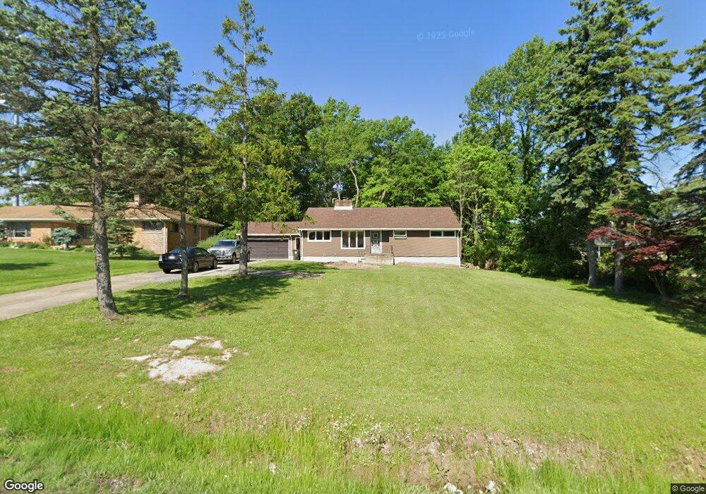
10800 State Rd North Royalton, OH 44133
Estimated Value: $255,000 - $294,000
3
Beds
2
Baths
1,338
Sq Ft
$202/Sq Ft
Est. Value
About This Home
This home is located at 10800 State Rd, North Royalton, OH 44133 and is currently estimated at $270,684, approximately $202 per square foot. 10800 State Rd is a home located in Cuyahoga County with nearby schools including North Royalton Middle School, North Royalton High School, and Saint Albert the Great Roman Catholic School.
Ownership History
Date
Name
Owned For
Owner Type
Purchase Details
Closed on
Apr 10, 2024
Sold by
Madaczky Dale W and Madaczky Daniel W
Bought by
Heyworth Claudette
Current Estimated Value
Home Financials for this Owner
Home Financials are based on the most recent Mortgage that was taken out on this home.
Original Mortgage
$184,000
Outstanding Balance
$181,282
Interest Rate
6.94%
Mortgage Type
New Conventional
Estimated Equity
$89,402
Purchase Details
Closed on
Jun 8, 1999
Sold by
Estate Of Edward W Madaczky
Bought by
Madaczky Dale W
Create a Home Valuation Report for This Property
The Home Valuation Report is an in-depth analysis detailing your home's value as well as a comparison with similar homes in the area
Home Values in the Area
Average Home Value in this Area
Purchase History
| Date | Buyer | Sale Price | Title Company |
|---|---|---|---|
| Heyworth Claudette | $230,000 | Gateway Title | |
| Madaczky Dale W | -- | -- |
Source: Public Records
Mortgage History
| Date | Status | Borrower | Loan Amount |
|---|---|---|---|
| Open | Heyworth Claudette | $184,000 |
Source: Public Records
Tax History Compared to Growth
Tax History
| Year | Tax Paid | Tax Assessment Tax Assessment Total Assessment is a certain percentage of the fair market value that is determined by local assessors to be the total taxable value of land and additions on the property. | Land | Improvement |
|---|---|---|---|---|
| 2024 | $4,147 | $81,200 | $13,370 | $67,830 |
| 2023 | $3,202 | $59,720 | $13,970 | $45,750 |
| 2022 | $3,206 | $59,710 | $13,965 | $45,745 |
| 2021 | $3,796 | $59,710 | $13,970 | $45,750 |
| 2020 | $3,444 | $51,490 | $12,040 | $39,450 |
| 2019 | $3,343 | $147,100 | $34,400 | $112,700 |
| 2018 | $3,187 | $51,490 | $12,040 | $39,450 |
| 2017 | $3,196 | $46,520 | $10,400 | $36,120 |
| 2016 | $2,995 | $46,520 | $10,400 | $36,120 |
| 2015 | $3,019 | $46,520 | $10,400 | $36,120 |
| 2014 | $3,019 | $46,520 | $10,400 | $36,120 |
Source: Public Records
Map
Nearby Homes
- 10628 Devonshire Dr
- 6560 Queens Way
- 10229 State Rd
- 5980 Wallings Rd
- 10620 Ridge Rd
- 4863 Maple Ln
- 3844 Wallings Rd
- 6451 Glenwillow Dr
- 10060 Brookside Cir
- 11490 Lisa Ln
- 3204 Thorn Tree Dr
- 3164 Fir Tree Dr
- 11960 Apollo Dr
- 10087 Jamestown Dr
- 9042 Vista Dr
- 9135 Vista Dr
- 6035 Woodland Bend Dr
- 4591 W Sprague Rd
- 3225 Helen Dr
- 8373 Hunting Dr
- 10812 State Rd
- 10780 State Rd
- 10910 State Rd
- 10726 State Rd
- 10787 State Rd
- 10789 State Rd
- 10724 State Rd
- Devonshire Dr
- 10619 Devonshire Dr
- 10585 Devonshire Rd
- 10720 State Rd
- 10655 State Rd
- 10639 Devonshire Dr
- 10575 Queens Way
- 10627 State Rd
- 10700 State Rd
- 10565 Queens Way
- 10555 Queens Way
- 10617 State Rd
- 10620 State Rd