Estimated Value: $212,000 - $220,302
3
Beds
2
Baths
1,210
Sq Ft
$179/Sq Ft
Est. Value
About This Home
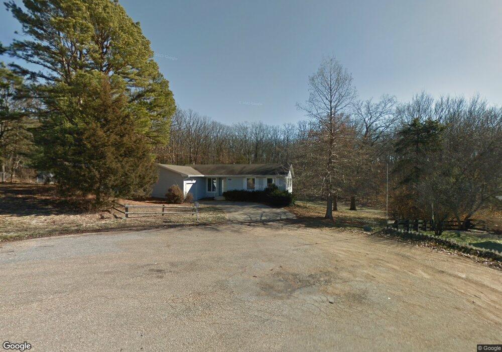
This home is located at 10802 Dennie Ct, Rolla, MO 65401 and is currently estimated at $216,826, approximately $179 per square foot. 10802 Dennie Ct is a home located in Phelps County with nearby schools including Rolla Junior High School, Rolla Senior High School, and St. Patrick School.
Ownership History
Date
Name
Owned For
Owner Type
Purchase Details
Closed on
Oct 31, 2013
Current Estimated Value
Purchase Details
Closed on
Dec 14, 2004
Purchase Details
Closed on
Jun 11, 2001
Purchase Details
Closed on
Nov 10, 1994
Purchase Details
Closed on
May 19, 1994
Purchase Details
Closed on
Apr 13, 1993
Purchase Details
Closed on
Jul 28, 1992
Purchase Details
Closed on
Oct 19, 1989
Purchase Details
Closed on
Sep 26, 1986
Purchase Details
Closed on
May 30, 1986
Purchase Details
Closed on
Dec 28, 1967
Create a Home Valuation Report for This Property
The Home Valuation Report is an in-depth analysis detailing your home's value as well as a comparison with similar homes in the area
Home Values in the Area
Average Home Value in this Area
Purchase History
| Date | Buyer | Sale Price | Title Company |
|---|---|---|---|
| -- | $87,000 | -- | |
| -- | -- | -- | |
| -- | -- | -- | |
| -- | -- | -- | |
| -- | -- | -- | |
| -- | -- | -- | |
| -- | -- | -- | |
| -- | -- | -- | |
| -- | -- | -- | |
| -- | -- | -- | |
| -- | -- | -- |
Source: Public Records
Tax History Compared to Growth
Tax History
| Year | Tax Paid | Tax Assessment Tax Assessment Total Assessment is a certain percentage of the fair market value that is determined by local assessors to be the total taxable value of land and additions on the property. | Land | Improvement |
|---|---|---|---|---|
| 2025 | $1,046 | $23,460 | $5,000 | $18,460 |
| 2024 | $1,046 | $20,490 | $3,710 | $16,780 |
| 2023 | $1,052 | $20,490 | $3,710 | $16,780 |
| 2022 | $885 | $20,490 | $3,710 | $16,780 |
| 2021 | $893 | $20,490 | $3,710 | $16,780 |
| 2020 | $816 | $18,300 | $3,710 | $14,590 |
| 2019 | $811 | $18,300 | $3,710 | $14,590 |
| 2018 | $803 | $18,300 | $3,710 | $14,590 |
| 2017 | $802 | $18,300 | $3,710 | $14,590 |
| 2016 | $775 | $18,300 | $3,710 | $14,590 |
| 2015 | -- | $18,300 | $3,710 | $14,590 |
| 2014 | -- | $18,300 | $3,710 | $14,590 |
| 2013 | -- | $18,300 | $0 | $0 |
Source: Public Records
Map
Nearby Homes
- 0 Faust Ct
- 0 Clayton Ct Unit MAR25028555
- 1330 California Dr
- 10575 Stoltz Dr
- 1603 Independence Rd
- 10900 Nolte Ct
- 1306 Broadway St
- 1500 Independence Rd
- 1510 Scenic Dr
- 1522 Oak Forest Dr
- 10335 Stoltz Dr
- 10556 Butler Cir
- 10366 County Road 3060
- 1325 Truman Ave
- 1404 Condo Dr
- 1607 Farrar Dr
- 1105 Missouri Ave
- 1 the Quarry Plat 4 Phase II
- 10677 Dolomite Cir
- 803 Lovers Ln
- 10820 Dennie Ct
- 10825 Clayton Ct
- 10815 Dennie Ct
- 10835 Dennie Ct
- 10802 Bullman Ct
- 10820 Bullman Ct
- 0 Jackling Ct
- 0 Jackling Ct Unit Lot 12 20053080
- 0 Jackling Ct Unit 14 20053101
- 10835 Clayton Ct
- 10855 Dennie Ct
- 10850 Dennie Ct
- 10830 Bullman Ct
- 10855 Clayton Ct
- 0 Bullman Ct Unit 167, 168
- 10850 Clayton Ct
- 10815 Bullman Ct
- 10850 Bullman Ct
- 10880 Dennie Ct