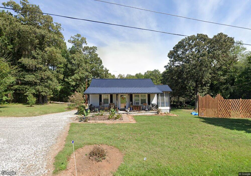
1081 Perth Rd Troutman, NC 28166
Estimated Value: $158,000 - $335,000
3
Beds
1
Bath
870
Sq Ft
$286/Sq Ft
Est. Value
About This Home
This home is located at 1081 Perth Rd, Troutman, NC 28166 and is currently estimated at $249,029, approximately $286 per square foot. 1081 Perth Rd is a home located in Iredell County with nearby schools including Troutman Elementary School, Troutman Middle School, and South Iredell High School.
Ownership History
Date
Name
Owned For
Owner Type
Purchase Details
Closed on
Nov 22, 2025
Sold by
Brown Jane Luffman
Bought by
Brown Jane Luffman and Brown Alicia D
Current Estimated Value
Purchase Details
Closed on
Dec 12, 2024
Sold by
Brown Ronnie Lee
Bought by
Brown Ronnie Lee and Brown Alicia D
Purchase Details
Closed on
Aug 15, 1997
Sold by
Brown Ronnie Lee
Bought by
Brown Ronnie Lee
Purchase Details
Closed on
Apr 1, 1985
Purchase Details
Closed on
Jun 1, 1974
Create a Home Valuation Report for This Property
The Home Valuation Report is an in-depth analysis detailing your home's value as well as a comparison with similar homes in the area
Home Values in the Area
Average Home Value in this Area
Purchase History
| Date | Buyer | Sale Price | Title Company |
|---|---|---|---|
| Brown Jane Luffman | -- | Royal Oak Title Company | |
| Brown Ronnie Lee | -- | None Listed On Document | |
| Brown Ronnie Lee | -- | None Listed On Document | |
| Brown Ronnie Lee | -- | -- | |
| -- | $21,000 | -- | |
| -- | $12,500 | -- |
Source: Public Records
Tax History
| Year | Tax Paid | Tax Assessment Tax Assessment Total Assessment is a certain percentage of the fair market value that is determined by local assessors to be the total taxable value of land and additions on the property. | Land | Improvement |
|---|---|---|---|---|
| 2025 | $842 | $130,290 | $71,040 | $59,250 |
| 2024 | $842 | $130,290 | $71,040 | $59,250 |
| 2023 | $842 | $130,290 | $71,040 | $59,250 |
| 2022 | $594 | $83,810 | $42,240 | $41,570 |
| 2021 | $582 | $83,810 | $42,240 | $41,570 |
| 2020 | $582 | $83,810 | $42,240 | $41,570 |
| 2019 | $561 | $83,810 | $42,240 | $41,570 |
| 2018 | $568 | $86,440 | $42,240 | $44,200 |
| 2017 | $568 | $86,440 | $42,240 | $44,200 |
| 2016 | $568 | $86,440 | $42,240 | $44,200 |
| 2015 | $568 | $86,440 | $42,240 | $44,200 |
| 2014 | $534 | $87,660 | $42,240 | $45,420 |
Source: Public Records
Map
Nearby Homes
- 155 Streamwood Rd
- 156 Ashmore Cir
- 187 Winding Creek Dr
- 299 Hamptons Cove Rd
- 215 Streamwood Rd
- 169 Winding Creek Dr
- 122 Lily Pad Loop
- 141 Winding Creek Dr
- 140 Shady Cove Rd
- 149 Shady Cove Rd
- 211 Honeycutt Rd
- 133 Crestview Ln Unit 15
- 125 Crestview Ln Unit 14
- 134 Millard Ln
- 124 Bentley Ct Unit 6
- 175 Falls Cove Dr
- 310 Hamptons Cove Rd
- 161 Fernview Trail Unit 9
- 110 Emmaline Ct
- 151 Outrigger Ln
- 1076 Perth Rd
- 130 Streamwood Rd
- 1072 Perth Rd
- 136 Streamwood Rd Unit 17
- 136 Streamwood Rd
- 106 Streamwood Rd Unit 13
- 1094 Perth Rd
- 1068 Perth Rd
- 110 Streamwood Rd
- 109 Perthwood Dr
- 1062 Perth Rd
- tbd Streamwood Ln
- 131 Streamwood Rd
- 119 Perthwood Dr
- Lot103 Streamwood Rd
- 123 Streamwood Rd
- 107 Streamwood Rd
- 107 Streamwood Rd Unit 3
- 121 Streamwood Rd
- 103 Streamwood Rd Unit 103
Your Personal Tour Guide
Ask me questions while you tour the home.