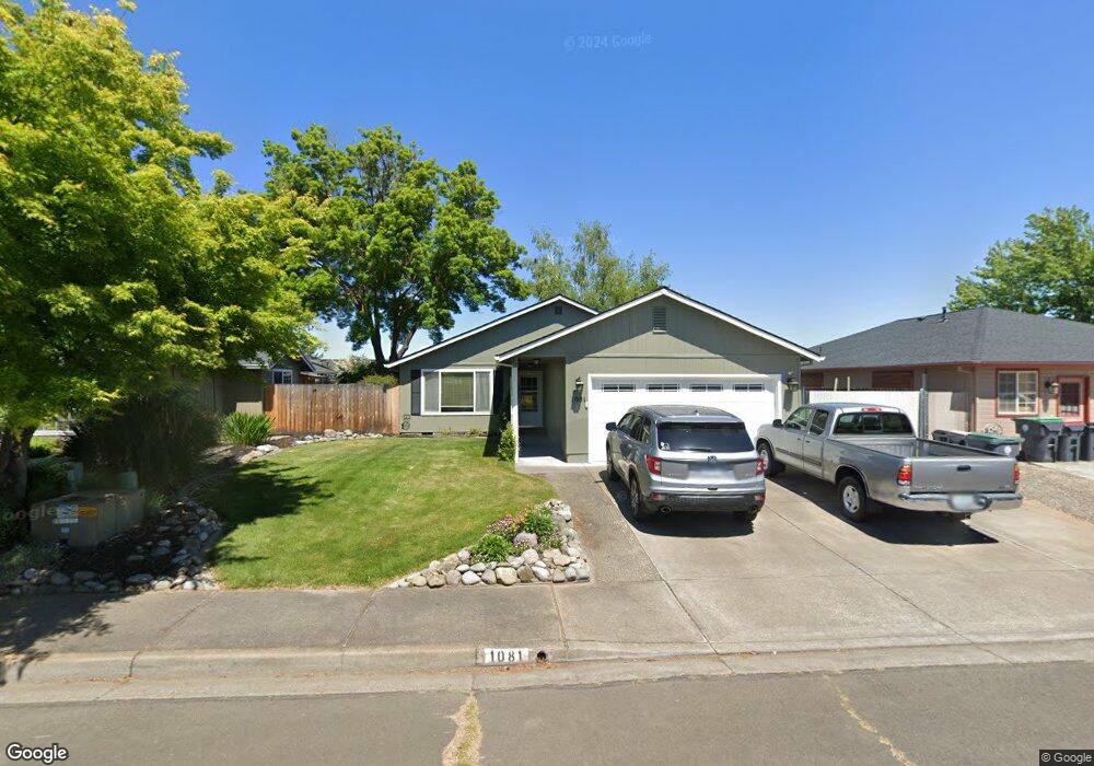
1081 Pittview Ave Central Point, OR 97502
Estimated Value: $334,000 - $382,000
3
Beds
2
Baths
1,244
Sq Ft
$289/Sq Ft
Est. Value
About This Home
This home is located at 1081 Pittview Ave, Central Point, OR 97502 and is currently estimated at $359,453, approximately $288 per square foot. 1081 Pittview Ave is a home located in Jackson County with nearby schools including Central Point Elementary School, Scenic Middle School, and Crater High School.
Ownership History
Date
Name
Owned For
Owner Type
Purchase Details
Closed on
Jan 9, 2006
Sold by
Belim Kenny E
Bought by
Bekefi Lissa C
Current Estimated Value
Home Financials for this Owner
Home Financials are based on the most recent Mortgage that was taken out on this home.
Original Mortgage
$235,000
Outstanding Balance
$129,640
Interest Rate
6.25%
Mortgage Type
Fannie Mae Freddie Mac
Estimated Equity
$229,813
Create a Home Valuation Report for This Property
The Home Valuation Report is an in-depth analysis detailing your home's value as well as a comparison with similar homes in the area
Purchase History
| Date | Buyer | Sale Price | Title Company |
|---|---|---|---|
| Bekefi Lissa C | $235,000 | Lawyers Title Ins |
Source: Public Records
Mortgage History
| Date | Status | Borrower | Loan Amount |
|---|---|---|---|
| Open | Bekefi Lissa C | $235,000 |
Source: Public Records
Tax History
| Year | Tax Paid | Tax Assessment Tax Assessment Total Assessment is a certain percentage of the fair market value that is determined by local assessors to be the total taxable value of land and additions on the property. | Land | Improvement |
|---|---|---|---|---|
| 2026 | $3,034 | $183,340 | -- | -- |
| 2025 | $2,959 | $178,000 | $52,860 | $125,140 |
| 2024 | $2,959 | $172,820 | $51,320 | $121,500 |
| 2023 | $2,864 | $167,790 | $49,830 | $117,960 |
| 2022 | $2,797 | $167,790 | $49,830 | $117,960 |
| 2021 | $2,718 | $162,910 | $48,380 | $114,530 |
| 2020 | $2,638 | $158,170 | $46,970 | $111,200 |
| 2019 | $2,573 | $149,100 | $44,270 | $104,830 |
| 2018 | $2,495 | $144,760 | $42,980 | $101,780 |
| 2017 | $2,432 | $144,760 | $42,980 | $101,780 |
| 2016 | $2,361 | $136,460 | $40,510 | $95,950 |
| 2015 | $2,262 | $136,460 | $40,510 | $95,950 |
| 2014 | $2,205 | $128,640 | $38,190 | $90,450 |
Source: Public Records
Map
Nearby Homes
- 1025 Fairfield Ave
- 992 Glengrove Ave
- 1258 Joshua Ct
- 918 Brandi Way
- 105 Queens Gate Ct
- 959 Westrop Dr
- 533 Brittni Ln
- 1204 Heather Ln
- 512 Village Dr Unit B5
- 3364 Bursell Rd
- 3358 Bursell Rd
- 736 Hemlock Ave
- 460 Federal Way
- 1283 Far West Ave Unit 3
- 2825 Howard Ave
- 2817 Howard Ave
- 402 Emerald Cir
- 555 Freeman Rd Unit 73
- 555 Freeman Rd Unit 254
- 555 Freeman Rd Unit 105
- 1075 Pittview Ave
- 1087 Pittview Ave
- 1069 Pittview Ave
- 1014 Fairfield Ave
- 1012 Fairfield Ave
- 1103 Hampton Dr
- 1123 Hampton Dr
- 1108 Looking Glass Way
- 1010 Fairfield Ave
- 1027 Pittview Ave
- 1108 Hampton Dr
- 1106 Hampton Dr
- 1127 Hampton Dr
- 1008 Fairfield Ave
- 1114 Looking Glass Way
- 1104 Hampton Dr
- 1019 Pittview Ave
- 955 Hampton Dr
- 1124 Hampton Dr
- 1018 Fairfield Ave
Your Personal Tour Guide
Ask me questions while you tour the home.