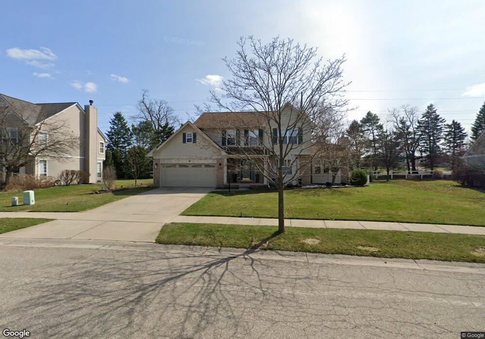
1081 Stable Ln South Lyon, MI 48178
Estimated Value: $431,209 - $490,000
3
Beds
3
Baths
2,033
Sq Ft
$228/Sq Ft
Est. Value
About This Home
This home is located at 1081 Stable Ln, South Lyon, MI 48178 and is currently estimated at $463,052, approximately $227 per square foot. 1081 Stable Ln is a home located in Oakland County with nearby schools including Frank E. Bartlett School, Centennial Middle School, and South Lyon High School.
Ownership History
Date
Name
Owned For
Owner Type
Purchase Details
Closed on
Nov 1, 2018
Sold by
Hotke Donald C and Hotke Terene M
Bought by
Hotke Donald C
Current Estimated Value
Purchase Details
Closed on
Apr 4, 2003
Sold by
Hotke Donald C and Hotke Terene M
Bought by
Hotke Donald C and Hotke Terene M
Purchase Details
Closed on
Nov 10, 1996
Sold by
Phoenix Investment Holdi
Bought by
Heritage Trotters Pt
Create a Home Valuation Report for This Property
The Home Valuation Report is an in-depth analysis detailing your home's value as well as a comparison with similar homes in the area
Home Values in the Area
Average Home Value in this Area
Purchase History
| Date | Buyer | Sale Price | Title Company |
|---|---|---|---|
| Hotke Donald C | -- | None Available | |
| Hotke Donald C | -- | -- | |
| Heritage Trotters Pt | -- | -- |
Source: Public Records
Tax History Compared to Growth
Tax History
| Year | Tax Paid | Tax Assessment Tax Assessment Total Assessment is a certain percentage of the fair market value that is determined by local assessors to be the total taxable value of land and additions on the property. | Land | Improvement |
|---|---|---|---|---|
| 2024 | $4,446 | $173,490 | $0 | $0 |
| 2023 | $4,172 | $162,320 | $0 | $0 |
| 2022 | $4,032 | $149,010 | $0 | $0 |
| 2021 | $3,837 | $143,910 | $0 | $0 |
| 2020 | $3,643 | $139,000 | $0 | $0 |
| 2019 | $3,724 | $134,280 | $0 | $0 |
| 2018 | $3,627 | $128,560 | $0 | $0 |
| 2017 | $3,645 | $127,220 | $0 | $0 |
| 2016 | $3,613 | $121,440 | $0 | $0 |
| 2015 | -- | $115,650 | $0 | $0 |
| 2014 | -- | $102,260 | $0 | $0 |
| 2011 | -- | $79,600 | $0 | $0 |
Source: Public Records
Map
Nearby Homes
- 61049 Greenwood Dr
- 61137 Greenwood Dr
- 61009 Greenwood Dr Unit 183
- 61051 Greenwood Dr
- 61264 Greenwood Dr Unit 77
- 61011 Greenwood Dr
- 61116 Greenwood Dr Unit 5
- 61961 Yorktown Dr Unit 4
- 61958 Ticonderoga Dr
- 62072 Yorktown Dr
- 25325 Potomac Dr Unit 3
- 62180 Arlington Cir Unit 5
- 25323 Potomac Dr Unit 2
- 61019 Evergreen Ct Unit 22
- The Columbia Plan at Sterling Trail
- The Oxford Plan at Sterling Trail
- The Hampton Plan at Sterling Trail
- The Austin Plan at Sterling Trail
- The Berkeley Plan at Sterling Trail
- The Princeton Plan at Sterling Trail
- 1087 Stable Ln Unit 90
- 1075 Stable Ln
- 61677 11 Mile Rd
- 61713 11 Mile Rd
- 1080 Stable Ln Unit 78
- 1086 Stable Ln
- 1093 Stable Ln
- 1069 Stable Ln
- 1074 Stable Ln
- 1099 Stable Ln
- 1092 Stable Ln
- 1099 Colt Dr
- 1063 Stable Ln Unit 86
- 1105 Stable Ln Unit 93
- 61661 11 Mile Rd
- 61661 11 Mile Rd Unit 4
- 1093 Colt Dr
- 1068 Stable Ln
- 1087 Colt Dr
- 1111 Colt Dr