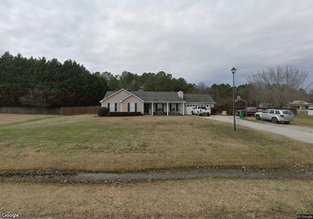
1082 Carter Dr Loganville, GA 30052
Walnut Grove NeighborhoodEstimated Value: $301,537 - $343,000
--
Bed
--
Bath
1,504
Sq Ft
$218/Sq Ft
Est. Value
About This Home
This home is located at 1082 Carter Dr, Loganville, GA 30052 and is currently estimated at $327,634, approximately $217 per square foot. 1082 Carter Dr is a home located in Walton County with nearby schools including Walnut Grove Elementary School, Youth Middle School, and Walnut Grove High School.
Ownership History
Date
Name
Owned For
Owner Type
Purchase Details
Closed on
May 22, 2001
Sold by
Emanuel Virginia L
Bought by
Tullis Jennifer L
Current Estimated Value
Home Financials for this Owner
Home Financials are based on the most recent Mortgage that was taken out on this home.
Original Mortgage
$99,900
Outstanding Balance
$37,275
Interest Rate
7.02%
Mortgage Type
New Conventional
Estimated Equity
$290,359
Purchase Details
Closed on
May 9, 2001
Sold by
Emanuel Frank
Bought by
Emanuel Virginia
Home Financials for this Owner
Home Financials are based on the most recent Mortgage that was taken out on this home.
Original Mortgage
$99,900
Outstanding Balance
$37,275
Interest Rate
7.02%
Mortgage Type
New Conventional
Estimated Equity
$290,359
Purchase Details
Closed on
Jan 19, 1996
Sold by
Carter Robert L
Bought by
Emanuel Frank Virginia
Create a Home Valuation Report for This Property
The Home Valuation Report is an in-depth analysis detailing your home's value as well as a comparison with similar homes in the area
Home Values in the Area
Average Home Value in this Area
Purchase History
| Date | Buyer | Sale Price | Title Company |
|---|---|---|---|
| Tullis Jennifer L | $129,900 | -- | |
| Emanuel Virginia | -- | -- | |
| Emanuel Frank Virginia | $92,900 | -- |
Source: Public Records
Mortgage History
| Date | Status | Borrower | Loan Amount |
|---|---|---|---|
| Open | Tullis Jennifer L | $99,900 |
Source: Public Records
Tax History Compared to Growth
Tax History
| Year | Tax Paid | Tax Assessment Tax Assessment Total Assessment is a certain percentage of the fair market value that is determined by local assessors to be the total taxable value of land and additions on the property. | Land | Improvement |
|---|---|---|---|---|
| 2024 | $2,296 | $104,040 | $17,200 | $86,840 |
| 2023 | $2,349 | $101,280 | $17,200 | $84,080 |
| 2022 | $2,164 | $84,080 | $13,200 | $70,880 |
| 2021 | $1,986 | $71,760 | $13,200 | $58,560 |
| 2020 | $1,901 | $65,360 | $11,600 | $53,760 |
| 2019 | $1,823 | $60,840 | $10,800 | $50,040 |
| 2018 | $1,803 | $60,840 | $10,800 | $50,040 |
| 2017 | $2,033 | $59,000 | $10,800 | $48,200 |
| 2016 | $1,759 | $57,160 | $10,800 | $46,360 |
| 2015 | $1,516 | $46,760 | $10,000 | $36,760 |
| 2014 | $1,149 | $34,960 | $0 | $0 |
Source: Public Records
Map
Nearby Homes
- 2361 Emerald Dr
- 4199 Wagon Trail
- LOT 12 Guthrie Cemetery Rd
- LOT 13 Guthrie Cemetery Rd
- 1265 Industrial Pkwy
- 110 Valley Dr
- 232 Cambridge Dr
- 1800 Walnut Ave
- 1230 Park St Unit 1
- 0 Emmett Still Rd Unit TRACT 04 20086873
- 608 Cambridge Terrace
- 1760 Highway 138
- 583 Overlook Rd
- 4820 Old Highway 138
- 89 Cowpen Ct
- 5117 Ashley Falls Ct
- 4983 Guthrie Cemetery Rd
- 2071 Habersham Cir
- 766 Youth Jersey Rd
- 720 Youth Jersey Rd
- 1092 Carter Dr
- 1072 Carter Dr
- 1083 Carter Dr
- 1512 Guthrie Crossing Dr
- 1516 Guthrie Crossing Dr
- 1520 Guthrie Crossing
- 1520 Guthrie Crossing Dr
- 1073 Carter Dr
- 1508 Guthrie Crossing Dr
- 4260 Guthrie Cemetery Rd
- 1102 Carter Dr
- 1093 Carter Dr
- 1504 Guthrie Crossing Dr
- 1500 Guthrie Crossing Dr
- 1050 Highway 81
- 4230 Guthrie Cemetery Rd
- 1509 Guthrie Crossing Dr
- 1020 Highway 81
- 2500 Emerald Dr
- 1513 Guthrie Crossing Dr