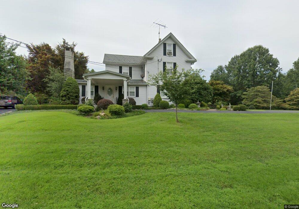
10826 Summit Ave Woodstock, MD 21163
Woodstock NeighborhoodEstimated Value: $377,616 - $600,000
--
Bed
2
Baths
2,208
Sq Ft
$221/Sq Ft
Est. Value
About This Home
This home is located at 10826 Summit Ave, Woodstock, MD 21163 and is currently estimated at $487,904, approximately $220 per square foot. 10826 Summit Ave is a home located in Baltimore County with nearby schools including Winfield Elementary School, Windsor Mill Middle School, and Randallstown High School.
Ownership History
Date
Name
Owned For
Owner Type
Purchase Details
Closed on
May 14, 2019
Sold by
Charles And Pjhyllis Mays Revocable Tr
Bought by
The Mays Family Trust
Current Estimated Value
Purchase Details
Closed on
Oct 13, 2011
Sold by
Mays Charles A and Mays Phyllis R
Bought by
Mays Charles A and Mays Phyllis R
Purchase Details
Closed on
Mar 13, 2003
Sold by
Mays Charles A
Bought by
Mays Charles A and Mays Phyllis R
Purchase Details
Closed on
Apr 21, 1999
Sold by
Mays Charles A
Bought by
Mays Charles A and Mays Phyllis R
Create a Home Valuation Report for This Property
The Home Valuation Report is an in-depth analysis detailing your home's value as well as a comparison with similar homes in the area
Home Values in the Area
Average Home Value in this Area
Purchase History
| Date | Buyer | Sale Price | Title Company |
|---|---|---|---|
| The Mays Family Trust | -- | None Available | |
| Mays Charles A | -- | None Available | |
| Mays Charles A | -- | None Available | |
| Mays Charles A | -- | -- | |
| Mays Charles A | -- | -- |
Source: Public Records
Tax History Compared to Growth
Tax History
| Year | Tax Paid | Tax Assessment Tax Assessment Total Assessment is a certain percentage of the fair market value that is determined by local assessors to be the total taxable value of land and additions on the property. | Land | Improvement |
|---|---|---|---|---|
| 2025 | $3,334 | $300,533 | -- | -- |
| 2024 | $3,334 | $277,500 | $97,300 | $180,200 |
| 2023 | $1,616 | $274,933 | $0 | $0 |
| 2022 | $3,091 | $272,367 | $0 | $0 |
| 2021 | $2,719 | $269,800 | $97,300 | $172,500 |
| 2020 | $3,076 | $253,767 | $0 | $0 |
| 2019 | $2,881 | $237,733 | $0 | $0 |
| 2018 | $2,638 | $221,700 | $76,800 | $144,900 |
| 2017 | $2,456 | $211,200 | $0 | $0 |
| 2016 | $2,924 | $200,700 | $0 | $0 |
| 2015 | $2,924 | $190,200 | $0 | $0 |
| 2014 | $2,924 | $190,200 | $0 | $0 |
Source: Public Records
Map
Nearby Homes
- 10645 Davis Ave
- 10719 Old Court Rd
- 10628 Saint Paul Ave
- 10313 Cavey Ln
- 1800 Mount Denali Dr
- 10185 Green Clover Dr
- 9113 Dogwood Rd
- 10205 Cabery Rd
- 10162 Bracken Dr
- 2218 Bromley Ct
- 1725 Marriottsville Rd
- 1795 Marriottsville Rd
- 2208 Merion Pond
- 11100 Chambers Ct Unit C
- 11100 Chambers Ct Unit F
- 3200 Peddicoat Ct
- 11120 Chambers Ct Unit Q
- 2111 Ganton Green
- 11130 Chambers Ct Unit H
- 2115 Ganton Green Unit G106
- 10826 Summit Ave Unit A
- 10826A Summit Ave
- 10832 Summit Ave
- 10828 Summit Ave
- 10821 Summit Ave
- 10825 Summit Ave
- 10819 Summit Ave
- 10902A Summit Ave
- 10902 Summit Ave
- 10902 Summit Ave Unit A
- 10818 Summit Ave
- 10913 Summit Ave
- 10814 Acme Ave
- 10815 Summit Ave
- 10817 Acme Ave
- 10915 Summit Ave
- 10904 Summit Ave
- 10812 Acme Ave
- 10813 Acme Ave
- 10908 Summit Ave