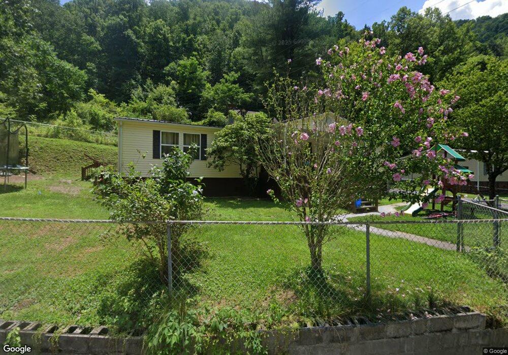
1083 Townsend Rd Vansant, VA 24656
Estimated Value: $56,223 - $92,000
3
Beds
1
Bath
1,092
Sq Ft
$68/Sq Ft
Est. Value
About This Home
This home is located at 1083 Townsend Rd, Vansant, VA 24656 and is currently estimated at $74,056, approximately $67 per square foot. 1083 Townsend Rd is a home located in Buchanan County with nearby schools including Riverview Elementary/Middle School and Grundy High School.
Ownership History
Date
Name
Owned For
Owner Type
Purchase Details
Closed on
May 17, 2013
Sold by
Osborne Bradley L and Osborne Chasity
Bought by
Ling William M
Current Estimated Value
Purchase Details
Closed on
Feb 24, 2012
Sold by
Ling William M
Bought by
Osborne Bradley L and Osborne Chasity
Create a Home Valuation Report for This Property
The Home Valuation Report is an in-depth analysis detailing your home's value as well as a comparison with similar homes in the area
Home Values in the Area
Average Home Value in this Area
Purchase History
| Date | Buyer | Sale Price | Title Company |
|---|---|---|---|
| Ling William M | -- | None Available | |
| Osborne Bradley L | $1,000 | Attorney |
Source: Public Records
Tax History Compared to Growth
Tax History
| Year | Tax Paid | Tax Assessment Tax Assessment Total Assessment is a certain percentage of the fair market value that is determined by local assessors to be the total taxable value of land and additions on the property. | Land | Improvement |
|---|---|---|---|---|
| 2024 | $94 | $24,000 | $2,300 | $21,700 |
| 2023 | $94 | $24,000 | $2,300 | $21,700 |
| 2022 | $94 | $24,000 | $2,300 | $21,700 |
| 2021 | $94 | $24,000 | $2,300 | $21,700 |
| 2020 | $79 | $20,200 | $2,300 | $17,900 |
| 2019 | $79 | $20,200 | $2,300 | $17,900 |
| 2017 | $79 | $20,200 | $2,300 | $17,900 |
| 2016 | $79 | $20,200 | $2,300 | $17,900 |
| 2015 | $79 | $6,000 | $6,000 | $0 |
Source: Public Records
Map
Nearby Homes
- 0 Dry Fork Rd
- 1877 Lovers Gap Rd
- TBD Cypress St
- 18775 Riverside Dr
- 1104 Little Prater Rd
- 1107 Russell Hill St
- 2477 Leemaster Dr
- 1025 White Birch Ln
- 1087 Greenhouse Cir
- 1078 Joe Hollow Rd
- TBD Riverside Dr
- 1154 Fairview St
- 9725 Garden Creek Rd
- 1075 Gator Rd
- 8232 Garden Creek Rd
- 2929 Slate Creek Rd
- 8836 Lovers Gap Rd
- 1014 Banner Rd
- 1079 Highlawn Cir
- 2967 Elkins Branch Rd
- 1099 Townsend Rd
- 1029 Townsend Rd
- 1776 Dry Fork Rd
- 1052 Townsend Rd
- 1045 Vandyke Rd
- 1793 Dry Fork Rd
- 1004 Townsend Rd
- 1643 Dry Fork Rd
- 1086 Cook Rd
- 1614 Dry Fork Rd
- 1010 Tahoe Rd
- 1543 Dry Fork Rd
- 1109 Tahoe Rd
- 1562 Dry Fork Rd
- 1506 Dry Fork Rd
- 2059 Dry Fork Rd
- 1192 Tahoe Rd
- 1131 Tahoe Rd
- 1539 Dry Fork Rd
- 1500 Dry Fork Rd