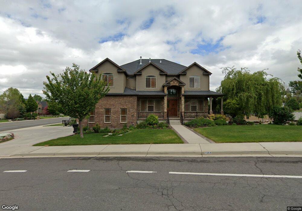
1084 S 2450 E Springville, UT 84663
East Hobble Creek NeighborhoodEstimated Value: $903,000 - $1,334,000
4
Beds
3
Baths
5,429
Sq Ft
$202/Sq Ft
Est. Value
About This Home
This home is located at 1084 S 2450 E, Springville, UT 84663 and is currently estimated at $1,097,266, approximately $202 per square foot. 1084 S 2450 E is a home located in Utah County with nearby schools including Hobble Creek School, Springville High School, and Springville Junior High School.
Ownership History
Date
Name
Owned For
Owner Type
Purchase Details
Closed on
Jan 29, 2007
Sold by
Anderson Karl S
Bought by
Anderson Karl S and Anderson Hisu Chin
Current Estimated Value
Home Financials for this Owner
Home Financials are based on the most recent Mortgage that was taken out on this home.
Original Mortgage
$564,800
Outstanding Balance
$337,350
Interest Rate
6.11%
Mortgage Type
Purchase Money Mortgage
Estimated Equity
$759,916
Purchase Details
Closed on
Oct 1, 2003
Sold by
Hobble Creek Cove Development Llc
Bought by
Dale F Dellamas Construction Inc
Home Financials for this Owner
Home Financials are based on the most recent Mortgage that was taken out on this home.
Original Mortgage
$972,600
Interest Rate
6.27%
Mortgage Type
Purchase Money Mortgage
Create a Home Valuation Report for This Property
The Home Valuation Report is an in-depth analysis detailing your home's value as well as a comparison with similar homes in the area
Home Values in the Area
Average Home Value in this Area
Purchase History
| Date | Buyer | Sale Price | Title Company |
|---|---|---|---|
| Anderson Karl S | -- | First American Title Agency | |
| Anderson Karl S | -- | First American Title Agency | |
| Dale F Dellamas Construction Inc | -- | Century Title |
Source: Public Records
Mortgage History
| Date | Status | Borrower | Loan Amount |
|---|---|---|---|
| Open | Anderson Karl S | $564,800 | |
| Closed | Anderson Karl S | $105,900 | |
| Previous Owner | Dale F Dellamas Construction Inc | $972,600 |
Source: Public Records
Tax History
| Year | Tax Paid | Tax Assessment Tax Assessment Total Assessment is a certain percentage of the fair market value that is determined by local assessors to be the total taxable value of land and additions on the property. | Land | Improvement |
|---|---|---|---|---|
| 2025 | $4,634 | $467,005 | -- | -- |
| 2024 | $4,634 | $474,705 | $0 | $0 |
| 2023 | $4,751 | $487,190 | $0 | $0 |
| 2022 | $5,636 | $567,655 | $0 | $0 |
| 2021 | $4,976 | $780,100 | $180,000 | $600,100 |
| 2020 | $4,762 | $723,700 | $156,500 | $567,200 |
| 2019 | $4,670 | $722,600 | $156,500 | $566,100 |
| 2018 | $4,653 | $686,900 | $194,600 | $492,300 |
| 2017 | $4,190 | $328,515 | $0 | $0 |
| 2016 | $3,693 | $283,855 | $0 | $0 |
| 2015 | $3,612 | $283,855 | $0 | $0 |
| 2014 | $3,594 | $280,610 | $0 | $0 |
Source: Public Records
Map
Nearby Homes
- 1052 Cove Dr
- 829 S 2200 E Unit 2
- 776 S 2200 E Unit 19
- 817 S 2200 E Unit 3
- 715 E 1700 N
- 2541 Stonebury Loop Rd
- 2295 E 700 S Unit 18
- 1567 N 600 E Unit 26
- 1884 Town And Country Rd
- 2881 Thirty Oaks Dr Unit 6
- 2881 Thirty Oaks Dr
- 52 E 775 S Unit 19
- 1447 N 1350 St E Unit 5
- 1577 N 1350 St E Unit 1
- 1477 N 1350 St E Unit 4
- 1547 N 1350 St E Unit 2
- 1511 N 1350 St E Unit 3
- 1548 N 1350 St E Unit 11
- 1578 N 1350 St E Unit 12
- 297 E 1250 St N
- 1076 S 2450 E
- 2453 River Bottom Rd
- 2442 River Bottom Rd
- 2442 E 1100 S
- 1048 S 2450 E
- 2404 River Bottom Rd
- 2458 River Bottom Rd
- 2471 River Bottom Rd
- 2447 Deer Creek Way
- 2382 E 1100 S
- 2382 River Bottom Rd
- 2411 Deer Creek Way
- 2420 Canyon Rd Unit 7
- 2420 Canyon Rd
- 1233 S 2450 E
- 2497 Riverbottom Rd Unit 12
- 2402 Canyon Rd
- 2402 Canyon Rd Unit 5
- 2391 Deer Creek Way
- 2344 River Bottom Rd
Your Personal Tour Guide
Ask me questions while you tour the home.