Estimated Value: $546,000 - $596,000
5
Beds
3
Baths
2,200
Sq Ft
$259/Sq Ft
Est. Value
About This Home
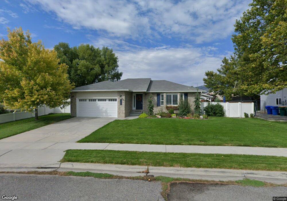
This home is located at 1085 E Airport Dr, Lehi, UT 84043 and is currently estimated at $570,057, approximately $259 per square foot. 1085 E Airport Dr is a home located in Utah County with nearby schools including Freedom Elementary School, Lehi Junior High School, and Skyridge High School.
Ownership History
Date
Name
Owned For
Owner Type
Purchase Details
Closed on
May 20, 2021
Sold by
Jensen Clark
Bought by
Jensen Dylan Wyatt
Current Estimated Value
Home Financials for this Owner
Home Financials are based on the most recent Mortgage that was taken out on this home.
Original Mortgage
$275,000
Outstanding Balance
$249,219
Interest Rate
3.1%
Mortgage Type
New Conventional
Estimated Equity
$320,838
Purchase Details
Closed on
Apr 28, 2021
Sold by
Laycock Shane and Laycock Julie
Bought by
Jensen Clark
Home Financials for this Owner
Home Financials are based on the most recent Mortgage that was taken out on this home.
Original Mortgage
$275,000
Outstanding Balance
$249,219
Interest Rate
3.1%
Mortgage Type
New Conventional
Estimated Equity
$320,838
Purchase Details
Closed on
May 24, 2018
Sold by
Laycock Shane
Bought by
Laycock Shane and Laycock Julie
Home Financials for this Owner
Home Financials are based on the most recent Mortgage that was taken out on this home.
Original Mortgage
$259,462
Interest Rate
4.87%
Mortgage Type
FHA
Purchase Details
Closed on
Dec 18, 2014
Sold by
Laycock Julie D and Laycock Lloyd E
Bought by
Laycock Shane and Laycock Julie
Home Financials for this Owner
Home Financials are based on the most recent Mortgage that was taken out on this home.
Original Mortgage
$211,894
Interest Rate
3.75%
Mortgage Type
FHA
Purchase Details
Closed on
Jul 20, 2011
Sold by
Robbins Josh and Robbins Courtney
Bought by
Laycock Julie D and Laycock Lloyd E
Home Financials for this Owner
Home Financials are based on the most recent Mortgage that was taken out on this home.
Original Mortgage
$193,955
Interest Rate
4.37%
Mortgage Type
FHA
Purchase Details
Closed on
Feb 18, 2010
Sold by
Federal National Mortgage Association
Bought by
Robbins Josh and Robbins Courtney
Home Financials for this Owner
Home Financials are based on the most recent Mortgage that was taken out on this home.
Original Mortgage
$176,900
Interest Rate
5.02%
Mortgage Type
New Conventional
Purchase Details
Closed on
Dec 16, 2009
Sold by
Day Steven E
Bought by
Federal National Mortgage Association
Purchase Details
Closed on
Jul 17, 2007
Sold by
Day Christopher Ryan
Bought by
Day Steven E
Home Financials for this Owner
Home Financials are based on the most recent Mortgage that was taken out on this home.
Original Mortgage
$280,000
Interest Rate
6.65%
Mortgage Type
Purchase Money Mortgage
Purchase Details
Closed on
Nov 10, 2006
Sold by
Smith Matthew D and Smith Krista Marie
Bought by
Day Christopher Ryan
Home Financials for this Owner
Home Financials are based on the most recent Mortgage that was taken out on this home.
Original Mortgage
$46,000
Interest Rate
6.36%
Mortgage Type
Stand Alone Second
Purchase Details
Closed on
Dec 2, 1997
Sold by
Smith Matthew D and Smith Krista Marie
Bought by
Smith Matthew D and Smith Krista Marie
Home Financials for this Owner
Home Financials are based on the most recent Mortgage that was taken out on this home.
Original Mortgage
$124,500
Interest Rate
7.31%
Mortgage Type
Balloon
Purchase Details
Closed on
Jul 22, 1997
Sold by
Patterson Construction Inc
Bought by
Smith Matthew D and Smith Krista Marie
Create a Home Valuation Report for This Property
The Home Valuation Report is an in-depth analysis detailing your home's value as well as a comparison with similar homes in the area
Home Values in the Area
Average Home Value in this Area
Purchase History
| Date | Buyer | Sale Price | Title Company |
|---|---|---|---|
| Jensen Dylan Wyatt | -- | Meridian Title Co | |
| Jensen Clark | -- | Meridian Title Co | |
| Laycock Shane | -- | North American Title | |
| Laycock Shane | -- | North American Title | |
| Laycock Shane | -- | North American Title | |
| Laycock Julie D | -- | Equity Title Orem Center St | |
| Robbins Josh | -- | Empire Land Title Inc | |
| Federal National Mortgage Association | $252,646 | Backman | |
| Day Steven E | -- | Executive Title | |
| Day Christopher Ryan | -- | Executive Title | |
| Smith Matthew D | -- | -- | |
| Smith Matthew D | -- | -- |
Source: Public Records
Mortgage History
| Date | Status | Borrower | Loan Amount |
|---|---|---|---|
| Open | Jensen Dylan Wyatt | $275,000 | |
| Previous Owner | Laycock Shane | $259,462 | |
| Previous Owner | Laycock Shane | $211,894 | |
| Previous Owner | Laycock Julie D | $193,955 | |
| Previous Owner | Robbins Josh | $176,900 | |
| Previous Owner | Day Steven E | $280,000 | |
| Previous Owner | Day Christopher Ryan | $46,000 | |
| Previous Owner | Day Christopher Ryan | $184,000 | |
| Previous Owner | Smith Matthew D | $124,500 |
Source: Public Records
Tax History Compared to Growth
Tax History
| Year | Tax Paid | Tax Assessment Tax Assessment Total Assessment is a certain percentage of the fair market value that is determined by local assessors to be the total taxable value of land and additions on the property. | Land | Improvement |
|---|---|---|---|---|
| 2025 | $2,175 | $283,855 | $208,200 | $307,900 |
| 2024 | $2,175 | $254,485 | $0 | $0 |
| 2023 | $2,012 | $255,640 | $0 | $0 |
| 2022 | $2,220 | $273,405 | $0 | $0 |
| 2021 | $1,979 | $368,500 | $120,500 | $248,000 |
| 2020 | $1,865 | $343,400 | $111,600 | $231,800 |
| 2019 | $1,637 | $313,200 | $111,600 | $201,600 |
| 2018 | $1,559 | $282,100 | $106,800 | $175,300 |
| 2017 | $1,453 | $139,755 | $0 | $0 |
| 2016 | $1,481 | $132,165 | $0 | $0 |
| 2015 | $1,473 | $124,740 | $0 | $0 |
| 2014 | $1,335 | $112,420 | $0 | $0 |
Source: Public Records
Map
Nearby Homes
- 975 E 2125 N
- 859 E 2125 N
- 2208 N 825 E
- 975 E 2850 N
- 9967 N 6670 W
- 192 E 2200 N
- 6692 W 9770 N
- 2539 N 300 E
- 4333 N Baiken Ridge Dr Unit 1020
- 9924 N 6630 W Unit 9
- 9435 N Aspen Hollow Cir
- 2159 N Banbury Ct
- 1175 E 900 N
- 1602 E Center Pointe Dr
- 1602 E Center Pointe Dr Unit 1
- 1610 E Center Pointe Dr
- 6399 W 10150 N
- 1295 N 190 E
- 3368 N 700 E
- 893 N 1580 E
- 1085 E Airport Dr
- 1067 E Airport Dr
- 1101 E Airport Dr
- 1101 E Airport Dr
- 1092 E 2180 N
- 2109 N 1100 E
- 1104 E 2180 N
- 1070 E 2180 N
- 1051 Airport Dr
- 1051 E Airport Dr
- 1119 Airport Dr
- 1064 E Airport Dr
- 1064 Airport Dr
- 2108 N 1100 E
- 1046 E Airport Dr
- 1033 Airport Dr
- 1033 E Airport Dr
- 1046 E Airport Dr
- 1044 E 2180 N
- 1147 E Airport Dr