Estimated Value: $408,717 - $692,000
--
Bed
--
Bath
--
Sq Ft
8,843
Sq Ft Lot
About This Home
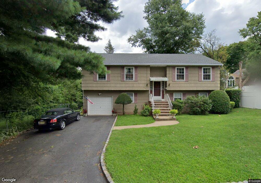
This home is located at 1085 Robin Ln, Union, NJ 07083 and is currently estimated at $604,429. 1085 Robin Ln is a home located in Union County with nearby schools including Livingston Elementary School, Union High School, and St Michael Parish School.
Ownership History
Date
Name
Owned For
Owner Type
Purchase Details
Closed on
May 19, 2011
Sold by
Sullivan Arlene and Boryschuk Andrew
Bought by
Tann Milton R and Tann Dyna
Current Estimated Value
Home Financials for this Owner
Home Financials are based on the most recent Mortgage that was taken out on this home.
Original Mortgage
$292,395
Outstanding Balance
$201,980
Interest Rate
4.75%
Mortgage Type
FHA
Estimated Equity
$402,449
Create a Home Valuation Report for This Property
The Home Valuation Report is an in-depth analysis detailing your home's value as well as a comparison with similar homes in the area
Home Values in the Area
Average Home Value in this Area
Purchase History
| Date | Buyer | Sale Price | Title Company |
|---|---|---|---|
| Tann Milton R | $300,000 | None Available |
Source: Public Records
Mortgage History
| Date | Status | Borrower | Loan Amount |
|---|---|---|---|
| Open | Tann Milton R | $292,395 |
Source: Public Records
Tax History Compared to Growth
Tax History
| Year | Tax Paid | Tax Assessment Tax Assessment Total Assessment is a certain percentage of the fair market value that is determined by local assessors to be the total taxable value of land and additions on the property. | Land | Improvement |
|---|---|---|---|---|
| 2025 | $11,690 | $52,300 | $17,000 | $35,300 |
| 2024 | $11,333 | $52,300 | $17,000 | $35,300 |
| 2023 | $11,333 | $52,300 | $17,000 | $35,300 |
| 2022 | $10,939 | $52,300 | $17,000 | $35,300 |
| 2021 | $10,674 | $52,300 | $17,000 | $35,300 |
| 2020 | $10,461 | $52,300 | $17,000 | $35,300 |
| 2019 | $10,320 | $52,300 | $17,000 | $35,300 |
| 2018 | $10,145 | $52,300 | $17,000 | $35,300 |
| 2017 | $9,995 | $52,300 | $17,000 | $35,300 |
| 2016 | $9,751 | $52,300 | $17,000 | $35,300 |
| 2015 | $9,589 | $52,300 | $17,000 | $35,300 |
| 2014 | $9,374 | $52,300 | $17,000 | $35,300 |
Source: Public Records
Map
Nearby Homes
- 1322 Marcella Dr
- 1393 Cornell Place
- 1040 Cranbrook Rd
- 1267 Erhardt St
- 553 Harvard Ave
- 314 Fitzpatrick St
- 507 Locust Ave
- 557 Yale Ave
- 286 Mclean Place
- 292 Crann St
- 142 Eastern Pkwy
- 169 Valley View Rd
- 875 Salem Rd
- 105 Liberty Ct Unit 105
- 365 Broadwell Ave
- 537 Us Highway 22
- 542 Leo St
- 525 Us Highway 22
- 617 Tillman St
- 393 Harvard Ave
- 1419 Brookside Dr
- 1084 Robin Ln
- 1415 Brookside Dr
- 1409 Brookside Dr
- 1078 Robin Ln
- 1405 Brookside Dr
- 1427 Brookside Dr
- 1429 Brookside Dr
- 1401 Brookside Dr
- 1433 Brookside Dr
- 1376 Brookside Dr
- 1397 Brookside Dr
- 1436 Vauxhall Rd
- 1436 Vauxhall Rd Unit 1
- 1072 Lorraine Ave
- 1439 Brookside Dr
- 1444 Vauxhall Rd
- 1068 Lorraine Ave
- 1404 Thelma Dr
- 1393 Brookside Dr