Estimated Value: $308,091 - $657,000
--
Bed
--
Bath
1,326
Sq Ft
$382/Sq Ft
Est. Value
About This Home
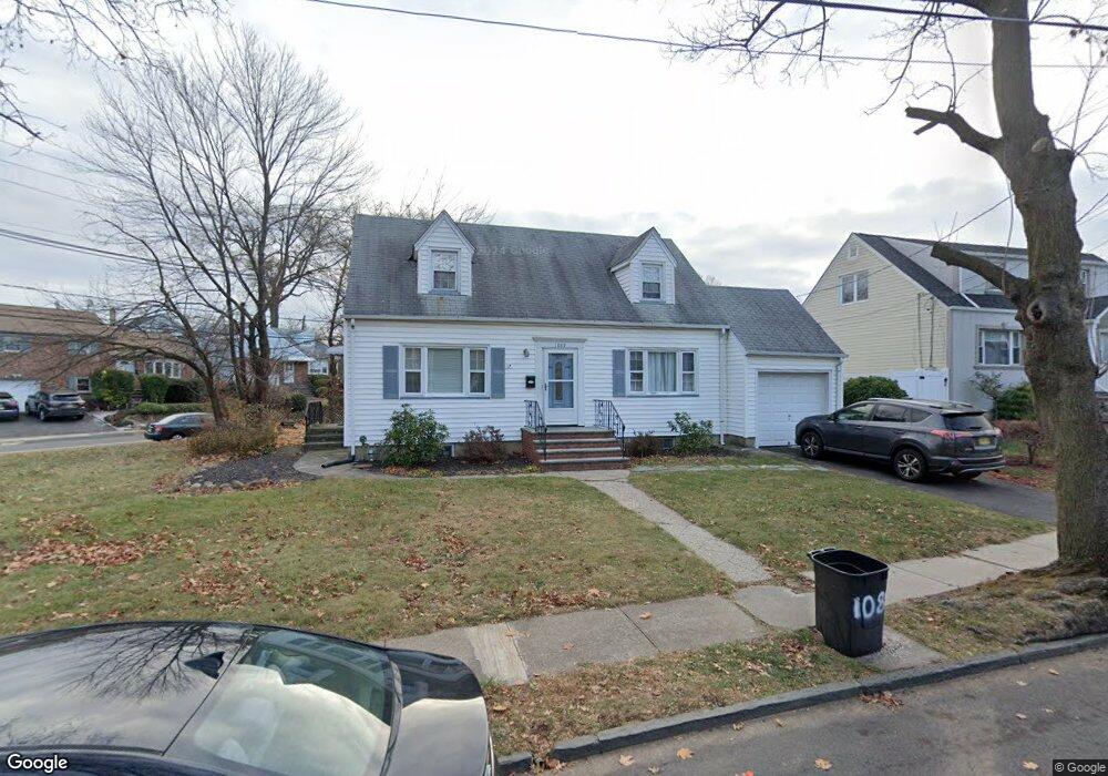
This home is located at 1085 Sterling Rd, Union, NJ 07083 and is currently estimated at $506,273, approximately $381 per square foot. 1085 Sterling Rd is a home located in Union County with nearby schools including Livingston Elementary School and Union High School.
Ownership History
Date
Name
Owned For
Owner Type
Purchase Details
Closed on
Oct 30, 2007
Sold by
Lande Patricia A Whitney and Whitney Greve F J
Bought by
Elmera Jean and Elmera Souffrance
Current Estimated Value
Home Financials for this Owner
Home Financials are based on the most recent Mortgage that was taken out on this home.
Original Mortgage
$275,000
Outstanding Balance
$174,801
Interest Rate
6.47%
Mortgage Type
Purchase Money Mortgage
Estimated Equity
$331,472
Create a Home Valuation Report for This Property
The Home Valuation Report is an in-depth analysis detailing your home's value as well as a comparison with similar homes in the area
Home Values in the Area
Average Home Value in this Area
Purchase History
| Date | Buyer | Sale Price | Title Company |
|---|---|---|---|
| Elmera Jean | $310,000 | New Jersey Title Ins Co |
Source: Public Records
Mortgage History
| Date | Status | Borrower | Loan Amount |
|---|---|---|---|
| Open | Elmera Jean | $275,000 |
Source: Public Records
Tax History Compared to Growth
Tax History
| Year | Tax Paid | Tax Assessment Tax Assessment Total Assessment is a certain percentage of the fair market value that is determined by local assessors to be the total taxable value of land and additions on the property. | Land | Improvement |
|---|---|---|---|---|
| 2025 | $9,879 | $44,200 | $23,100 | $21,100 |
| 2024 | $9,578 | $44,200 | $23,100 | $21,100 |
| 2023 | $9,578 | $44,200 | $23,100 | $21,100 |
| 2022 | $9,245 | $44,200 | $23,100 | $21,100 |
| 2021 | $9,021 | $44,200 | $23,100 | $21,100 |
| 2020 | $8,841 | $44,200 | $23,100 | $21,100 |
| 2019 | $8,722 | $44,200 | $23,100 | $21,100 |
| 2018 | $8,573 | $44,200 | $23,100 | $21,100 |
| 2017 | $8,447 | $44,200 | $23,100 | $21,100 |
| 2016 | $8,241 | $44,200 | $23,100 | $21,100 |
| 2015 | $8,104 | $44,200 | $23,100 | $21,100 |
| 2014 | $7,922 | $44,200 | $23,100 | $21,100 |
Source: Public Records
Map
Nearby Homes
- 1322 Marcella Dr
- 1393 Cornell Place
- 969 Arnet Ave
- 314 Fitzpatrick St
- 1370 Beverly Rd
- 292 Crann St
- 507 Locust Ave
- 410 Rutgers Ave
- 875 Salem Rd
- 1040 Cranbrook Rd
- 553 Harvard Ave
- 750 Midland Blvd
- 1267 Erhardt St
- 557 Yale Ave
- 365 Broadwell Ave
- 1048 Chester St
- 393 Harvard Ave
- 286 Mclean Place
- 257 Herbert Ave
- 537 Us Highway 22
- 1077 Sterling Rd
- 1367 Vauxhall Rd
- 1363 Vauxhall Rd
- 1371 Vauxhall Rd
- 1075 Sterling Rd
- 1084 Sterling Rd
- 1084 Sterling Rd Unit 1
- 1360 Vauxhall Rd
- 1080 Sterling Rd
- 1375 Vauxhall Rd
- 1078 Sterling Rd
- 1210 Wildwood Terrace
- 1355 Vauxhall Rd
- 1071 Sterling Rd
- 1352 Vauxhall Rd
- 1381 Vauxhall Rd
- 1072 Sterling Rd
- 1377 Brookside Dr
- 1216 Wildwood Terrace
- 1349 Vauxhall Rd