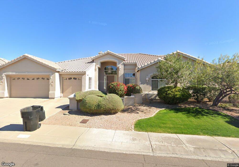
10865 N 122nd St Scottsdale, AZ 85259
Shea Corridor NeighborhoodEstimated Value: $1,084,293 - $1,434,000
--
Bed
5
Baths
3,358
Sq Ft
$383/Sq Ft
Est. Value
About This Home
This home is located at 10865 N 122nd St, Scottsdale, AZ 85259 and is currently estimated at $1,285,823, approximately $382 per square foot. 10865 N 122nd St is a home located in Maricopa County with nearby schools including Anasazi Elementary School, Mountainside Middle School, and Desert Mountain High School.
Ownership History
Date
Name
Owned For
Owner Type
Purchase Details
Closed on
Feb 2, 2019
Sold by
Patrick Mark and Estate Of Ueal E Patrick
Bought by
Patrick Steven E
Current Estimated Value
Purchase Details
Closed on
Aug 19, 2014
Sold by
Patrick Katherine and Patrick U
Bought by
Patrick U E and Patrick Katherine
Home Financials for this Owner
Home Financials are based on the most recent Mortgage that was taken out on this home.
Original Mortgage
$320,000
Outstanding Balance
$244,090
Interest Rate
4.12%
Estimated Equity
$1,041,733
Purchase Details
Closed on
Jul 21, 1995
Sold by
Stringer Gary and Stringer Rita L
Bought by
Patrick U E
Home Financials for this Owner
Home Financials are based on the most recent Mortgage that was taken out on this home.
Original Mortgage
$252,000
Interest Rate
5.75%
Mortgage Type
New Conventional
Create a Home Valuation Report for This Property
The Home Valuation Report is an in-depth analysis detailing your home's value as well as a comparison with similar homes in the area
Home Values in the Area
Average Home Value in this Area
Purchase History
| Date | Buyer | Sale Price | Title Company |
|---|---|---|---|
| Patrick Steven E | -- | None Available | |
| Patrick U E | -- | Lawyers Title Of Arizona Inc | |
| Patrick U E | -- | Lawyers Title Of Arizona Inc | |
| Patrick U E | $315,000 | Fidelity Title |
Source: Public Records
Mortgage History
| Date | Status | Borrower | Loan Amount |
|---|---|---|---|
| Open | Patrick U E | $320,000 | |
| Closed | Patrick U E | $320,000 | |
| Previous Owner | Patrick U E | $252,000 |
Source: Public Records
Tax History Compared to Growth
Tax History
| Year | Tax Paid | Tax Assessment Tax Assessment Total Assessment is a certain percentage of the fair market value that is determined by local assessors to be the total taxable value of land and additions on the property. | Land | Improvement |
|---|---|---|---|---|
| 2025 | $4,004 | $69,369 | -- | -- |
| 2024 | $4,653 | $66,066 | -- | -- |
| 2023 | $4,653 | $81,530 | $16,300 | $65,230 |
| 2022 | $4,416 | $62,410 | $12,480 | $49,930 |
| 2021 | $4,689 | $57,070 | $11,410 | $45,660 |
| 2020 | $4,687 | $55,030 | $11,000 | $44,030 |
| 2019 | $4,528 | $54,370 | $10,870 | $43,500 |
| 2018 | $4,384 | $49,710 | $9,940 | $39,770 |
| 2017 | $4,210 | $49,230 | $9,840 | $39,390 |
| 2016 | $4,107 | $46,550 | $9,310 | $37,240 |
| 2015 | $3,931 | $46,380 | $9,270 | $37,110 |
Source: Public Records
Map
Nearby Homes
- 10833 N 122nd St
- 12183 E Mercer Ln
- 12134 E Mercer Ln
- 12055 E Clinton St
- 12324 E Shangri la Rd
- xx E Shea Blvd Unit 1
- 10713 N 124th Place
- 12329 E North Ln
- 12348 E Shangri la Rd Unit 9
- 12053 E Yucca St
- 12540 E Mercer Ln
- 11933 E Becker Ln
- 10488 N 119th Place
- 10723 N 118th Way
- 12115 E Cortez Dr
- Plan Two at Emerald Hills
- Plan One at Emerald Hills
- 12399 E Gold Dust Ave
- 12120 E Cortez Dr
- 12595 E Cochise Dr
- 10897 N 122nd St
- 12196 E Sahuaro Dr
- 10801 N 122nd St
- 10929 N 122nd St
- 12199 E Mercer Ln
- 10882 N 123rd St
- 12188 E Sahuaro Dr
- 12197 E Sahuaro Dr Unit LOVLEY
- 12197 E Sahuaro Dr
- 10910 N 123rd St
- 10854 N 123rd St
- 10961 N 122nd St
- 10938 N 123rd St
- 12189 E Sahuaro Dr
- 12198 E Mercer Ln
- 12180 E Sahuaro Dr
- 12229 E Desert Cove Ave
- 12167 E Mercer Ln
- 10966 N 123rd St
- 10993 N 122nd St