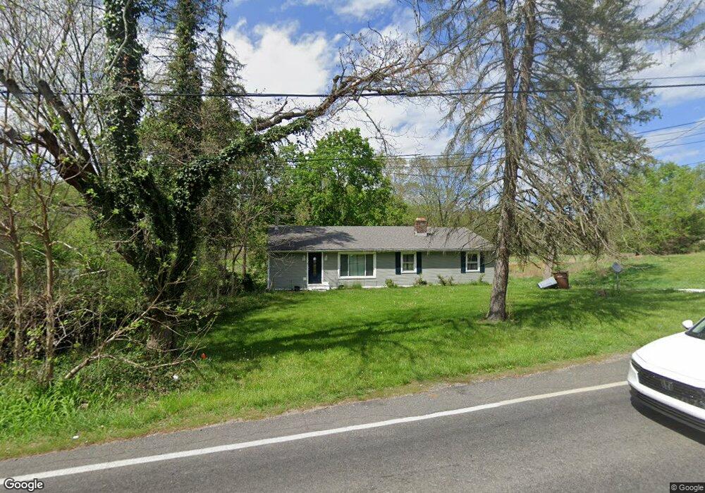
1087 Krumroy Rd Akron, OH 44306
Ellet NeighborhoodEstimated Value: $176,402 - $216,000
3
Beds
2
Baths
1,500
Sq Ft
$130/Sq Ft
Est. Value
About This Home
This home is located at 1087 Krumroy Rd, Akron, OH 44306 and is currently estimated at $194,351, approximately $129 per square foot. 1087 Krumroy Rd is a home located in Summit County with nearby schools including Springfield High School, Eagle Elementary, and Chapel Hill Christian School-Green Campus.
Ownership History
Date
Name
Owned For
Owner Type
Purchase Details
Closed on
May 27, 2015
Sold by
Porter Cortney N
Bought by
Porter Malcolm K
Current Estimated Value
Purchase Details
Closed on
Dec 15, 2005
Sold by
Yoak David N and Yoak Judy M
Bought by
Porter Malcolm K and Porter Cortney N
Home Financials for this Owner
Home Financials are based on the most recent Mortgage that was taken out on this home.
Original Mortgage
$91,920
Interest Rate
8.24%
Mortgage Type
Fannie Mae Freddie Mac
Create a Home Valuation Report for This Property
The Home Valuation Report is an in-depth analysis detailing your home's value as well as a comparison with similar homes in the area
Home Values in the Area
Average Home Value in this Area
Purchase History
| Date | Buyer | Sale Price | Title Company |
|---|---|---|---|
| Porter Malcolm K | -- | None Available | |
| Porter Malcolm K | $114,900 | Approved Statewide Title |
Source: Public Records
Mortgage History
| Date | Status | Borrower | Loan Amount |
|---|---|---|---|
| Closed | Porter Malcolm K | $91,920 |
Source: Public Records
Tax History
| Year | Tax Paid | Tax Assessment Tax Assessment Total Assessment is a certain percentage of the fair market value that is determined by local assessors to be the total taxable value of land and additions on the property. | Land | Improvement |
|---|---|---|---|---|
| 2024 | $3,541 | $48,462 | $12,569 | $35,893 |
| 2023 | $3,541 | $48,462 | $12,569 | $35,893 |
| 2022 | $3,192 | $36,523 | $9,450 | $27,073 |
| 2021 | $3,134 | $36,523 | $9,450 | $27,073 |
| 2020 | $3,101 | $36,520 | $9,450 | $27,070 |
| 2019 | $3,055 | $33,180 | $8,510 | $24,670 |
| 2018 | $2,968 | $33,180 | $8,510 | $24,670 |
| 2017 | $2,802 | $33,180 | $8,510 | $24,670 |
| 2016 | $2,713 | $28,020 | $8,510 | $19,510 |
| 2015 | $2,802 | $28,020 | $8,510 | $19,510 |
| 2014 | $2,779 | $28,020 | $8,510 | $19,510 |
| 2013 | -- | $31,530 | $8,510 | $23,020 |
Source: Public Records
Map
Nearby Homes
- 1190 Swartz Rd
- 1785 Mohawk Dr
- 1212 Derbydale Rd
- 1653 Mohawk Dr
- 1674 Betz Dr
- 1649 Betz Rd
- 1608 Mohawk Dr Unit 1610
- 2057 Darnell Dr
- 1554 Woods Rd
- 1031 Archmere Dr
- 1899 Edwards Dr
- 1088 Buena Vista Dr
- 1664 Woods Rd
- 801 Chaffin Rd
- 1713 Woods Rd
- 785 Chenoweth Extension
- 0 Woodview Dr
- 1724 Krumroy Rd
- 960 Impala Dr
- 2146 Stonehenge Cir
- 1085 Krumroy Rd
- 1111 Krumroy Rd
- 1106 Krumroy Rd
- 1086 Krumroy Rd
- 1094 Krumroy Rd
- 1115 Krumroy Rd
- 1115 Krumroy Rd
- 1074 Krumroy Rd
- 1043 Krumroy Rd
- 1043 Krumroy Rd
- 1129 Krumroy Rd
- 1126 Krumroy Rd
- 2025 Lee Dr
- 2037 Lee Dr
- 1136 Krumroy Rd
- 1137 Krumroy Rd
- 2035 Lee Dr
- 2014 Lee Dr
- 1145 Krumroy Rd
- 1220 Swartz Rd
Your Personal Tour Guide
Ask me questions while you tour the home.