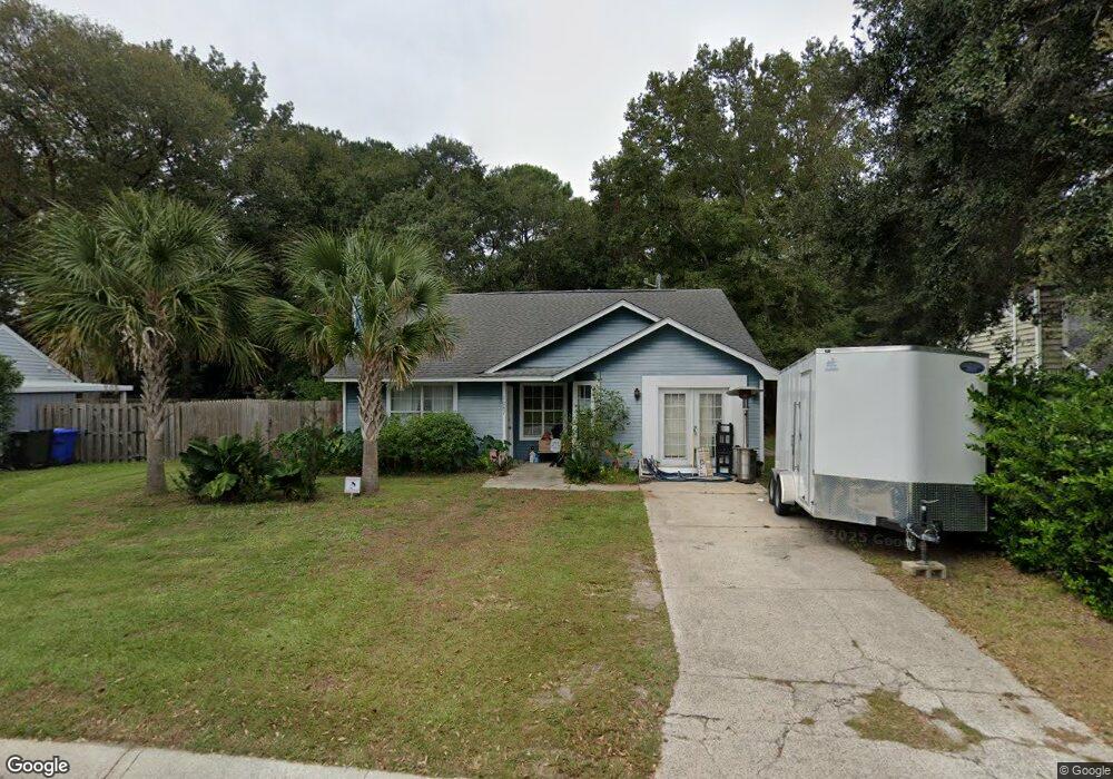
1087 Oakcrest Dr Charleston, SC 29412
James Island NeighborhoodEstimated Value: $468,376 - $584,000
3
Beds
2
Baths
1,470
Sq Ft
$351/Sq Ft
Est. Value
About This Home
This home is located at 1087 Oakcrest Dr, Charleston, SC 29412 and is currently estimated at $515,594, approximately $350 per square foot. 1087 Oakcrest Dr is a home located in Charleston County with nearby schools including James Island Elementary School, Camp Road Middle, and Septima P Clark Corporate Academy.
Ownership History
Date
Name
Owned For
Owner Type
Purchase Details
Closed on
Apr 27, 2021
Sold by
Duncan Smith Paul
Bought by
Smith Martin R and Smith Sandra C
Current Estimated Value
Home Financials for this Owner
Home Financials are based on the most recent Mortgage that was taken out on this home.
Original Mortgage
$220,000
Interest Rate
2.9%
Mortgage Type
New Conventional
Purchase Details
Closed on
Aug 4, 2008
Sold by
Smith Martin
Bought by
Smith Paul Duncan and Smith Rosemary
Purchase Details
Closed on
Aug 20, 2004
Sold by
Stalker Jason
Bought by
Smith Paul Duncan and Smith Rosemary
Create a Home Valuation Report for This Property
The Home Valuation Report is an in-depth analysis detailing your home's value as well as a comparison with similar homes in the area
Home Values in the Area
Average Home Value in this Area
Purchase History
| Date | Buyer | Sale Price | Title Company |
|---|---|---|---|
| Smith Martin R | $275,000 | Steadman Law Firm Pa | |
| Smith Paul Duncan | -- | -- | |
| Smith Paul Duncan | $164,000 | -- |
Source: Public Records
Mortgage History
| Date | Status | Borrower | Loan Amount |
|---|---|---|---|
| Previous Owner | Smith Martin R | $220,000 |
Source: Public Records
Tax History
| Year | Tax Paid | Tax Assessment Tax Assessment Total Assessment is a certain percentage of the fair market value that is determined by local assessors to be the total taxable value of land and additions on the property. | Land | Improvement |
|---|---|---|---|---|
| 2024 | $5,895 | $18,030 | $0 | $0 |
| 2023 | $5,263 | $18,030 | $0 | $0 |
| 2022 | $4,860 | $18,030 | $0 | $0 |
| 2021 | $3,426 | $12,760 | $0 | $0 |
| 2020 | $3,402 | $12,760 | $0 | $0 |
| 2019 | $3,114 | $11,100 | $0 | $0 |
| 2017 | $2,977 | $11,100 | $0 | $0 |
| 2016 | $2,882 | $11,100 | $0 | $0 |
| 2015 | $2,753 | $11,100 | $0 | $0 |
| 2014 | $2,685 | $0 | $0 | $0 |
| 2011 | -- | $0 | $0 | $0 |
Source: Public Records
Map
Nearby Homes
- 1131 Bellwood Rd
- 1135 Bellwood Rd
- 1165 Rivercrest Dr
- 1153 Pauline Ave
- 1133 Oakcrest Dr
- 1530 Fort Johnson Rd Unit 1G
- 1530 Fort Johnson Rd Unit 1E
- 1530 Fort Johnson Rd Unit 2B
- 1530 Fort Johnson Rd Unit 1L
- 1530 Fort Johnson Rd Unit 1C
- 1219 Pauline Ave
- 1156 Pittsford Cir
- 1333 Mapleton Ave
- 1072 Kentwood Cir
- 1540 Fort Johnson Rd
- 1099 Farmington Rd
- 1815 Walsingham Way
- 1403 Dove Run Dr Unit B
- 1039 Yorktown Dr
- 914 Dill Ave
- 1083 Oakcrest Dr
- 1091 Oakcrest Dr
- 1119 Sexton Dr
- 1130 Pauline Ave
- 1079 Oakcrest Dr
- 1126 Pauline Ave
- 1090 Oakcrest Dr
- 1136 Pauline Ave
- 1115 Sexton Dr
- 1084 Oakcrest Dr
- 1075 Oakcrest Dr
- 1122 Sexton Dr
- 1120 Pauline Ave
- 1080 Oakcrest Dr
- 1142 Pauline Ave
- 1094 Oakcrest Dr
- 1076 Oakcrest Dr
- 1118 Sexton Dr
- 1110 Sexton Dr
- 1133 Rivercrest Dr
Your Personal Tour Guide
Ask me questions while you tour the home.