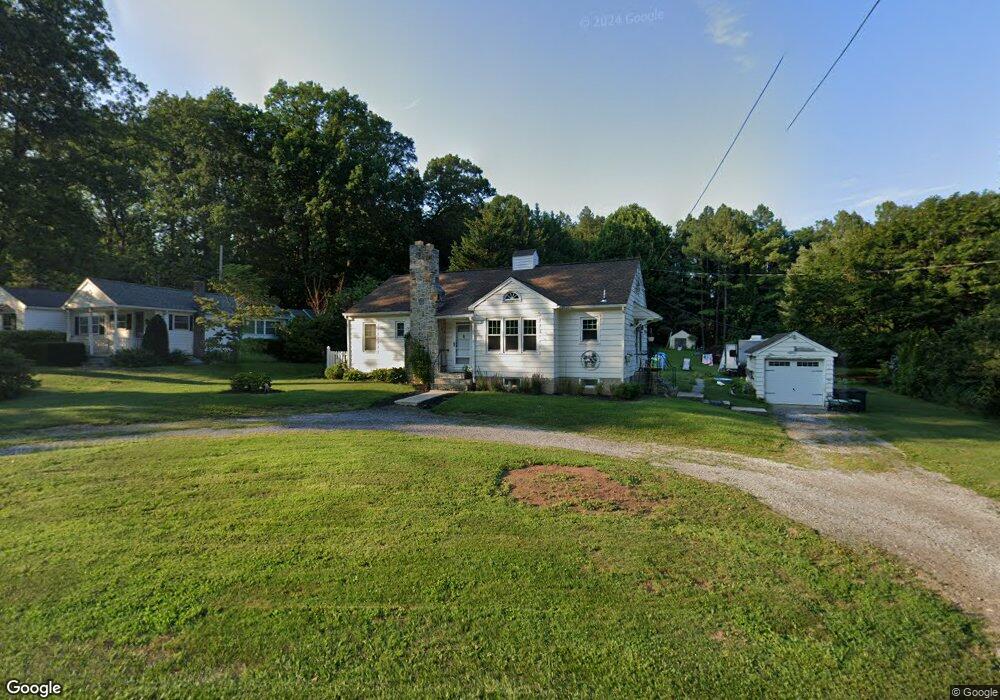
1087 Porters Rd Spring Grove, PA 17362
Estimated Value: $226,946 - $245,000
2
Beds
1
Bath
1,252
Sq Ft
$189/Sq Ft
Est. Value
About This Home
This home is located at 1087 Porters Rd, Spring Grove, PA 17362 and is currently estimated at $236,237, approximately $188 per square foot. 1087 Porters Rd is a home located in York County with nearby schools including Spring Grove Area Middle School, Spring Grove Area High School, and Garbers Mennonite School.
Ownership History
Date
Name
Owned For
Owner Type
Purchase Details
Closed on
Aug 25, 2002
Sold by
Kramer Dennis M and Curry Adam G
Bought by
Falduto Bernard J
Current Estimated Value
Home Financials for this Owner
Home Financials are based on the most recent Mortgage that was taken out on this home.
Original Mortgage
$86,317
Outstanding Balance
$36,452
Interest Rate
6.39%
Mortgage Type
FHA
Estimated Equity
$199,785
Purchase Details
Closed on
Oct 7, 1996
Bought by
Kramer Dennis M
Create a Home Valuation Report for This Property
The Home Valuation Report is an in-depth analysis detailing your home's value as well as a comparison with similar homes in the area
Home Values in the Area
Average Home Value in this Area
Purchase History
| Date | Buyer | Sale Price | Title Company |
|---|---|---|---|
| Falduto Bernard J | $87,000 | -- | |
| Kramer Dennis M | $81,000 | -- |
Source: Public Records
Mortgage History
| Date | Status | Borrower | Loan Amount |
|---|---|---|---|
| Open | Falduto Bernard J | $86,317 |
Source: Public Records
Tax History Compared to Growth
Tax History
| Year | Tax Paid | Tax Assessment Tax Assessment Total Assessment is a certain percentage of the fair market value that is determined by local assessors to be the total taxable value of land and additions on the property. | Land | Improvement |
|---|---|---|---|---|
| 2025 | $3,643 | $108,420 | $43,140 | $65,280 |
| 2024 | $3,604 | $108,420 | $43,140 | $65,280 |
| 2023 | $3,604 | $108,420 | $43,140 | $65,280 |
| 2022 | $3,604 | $108,420 | $43,140 | $65,280 |
| 2021 | $3,450 | $108,420 | $43,140 | $65,280 |
| 2020 | $3,450 | $108,420 | $43,140 | $65,280 |
| 2019 | $3,376 | $108,420 | $43,140 | $65,280 |
| 2018 | $3,331 | $108,420 | $43,140 | $65,280 |
| 2017 | $3,228 | $108,420 | $43,140 | $65,280 |
| 2016 | -- | $108,420 | $43,140 | $65,280 |
| 2015 | $2,157 | $108,420 | $43,140 | $65,280 |
| 2014 | $2,157 | $108,420 | $43,140 | $65,280 |
Source: Public Records
Map
Nearby Homes
- 1063 Porters Rd
- 6428 York Rd
- 5931 York Rd
- 1323 Moulstown Rd N
- 6475 Pamadeva Rd
- 5497 Stambaugh Rd
- 1233 Glatco Lodge Rd
- 1709 Jefferson Rd
- 1495 Jefferson Rd
- Lot # 2 Midhill Rd
- Lot # 1 Midhill Rd
- Lot# 3 Midhill Rd
- 0 Moulstown Rd N Unit PAYK2082362
- 7877 Gnatstown Rd
- 7962 Woodland Dr
- 799 Laurel Woods Ln
- 6306 Liam Dr
- 6309 Liam Dr
- 6313 Liam Dr
- 6319 Liam Dr
- 1093 Porters Rd
- 1099 Porters Rd
- 1101 Porters Rd
- 1072 Porters Rd
- 6305 Shutt Rd
- 1066 Porters Rd
- 1105 Porters Rd
- 6298 Hill Top Dr E
- 1083 Clinton Ct
- 1091 Clinton Ct
- 6270 Hill Top Dr E
- 6284 Hill Top Dr E
- 1077 Clinton Ct
- 6270 Hilltop Dr E
- 1071 Clinton Ct
- 6252 Hill Top Dr E
- 1051 Porters Rd
- 1112 Porters Rd
- 1099 Clinton Ct
- 6106 Hill Top Dr E