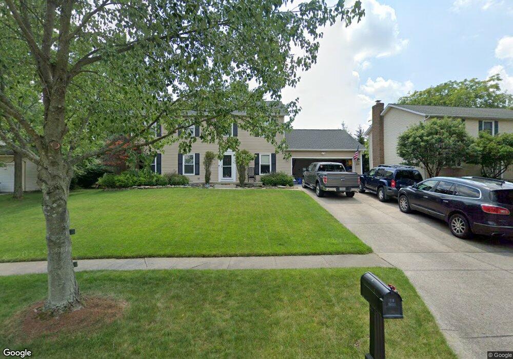
1088 Brookpoint Dr Medina, OH 44256
Estimated Value: $382,284 - $399,000
4
Beds
3
Baths
2,520
Sq Ft
$156/Sq Ft
Est. Value
About This Home
This home is located at 1088 Brookpoint Dr, Medina, OH 44256 and is currently estimated at $392,821, approximately $155 per square foot. 1088 Brookpoint Dr is a home located in Medina County with nearby schools including Heritage Elementary School, Claggett Middle School, and Medina High School.
Ownership History
Date
Name
Owned For
Owner Type
Purchase Details
Closed on
May 11, 2018
Sold by
Bethany Michael W and Bethany Kara L
Bought by
Bethany and Bethany Michael W
Current Estimated Value
Purchase Details
Closed on
Dec 19, 2007
Sold by
Novak Walter F and Novak Linda L
Bought by
Bethany Michael W
Home Financials for this Owner
Home Financials are based on the most recent Mortgage that was taken out on this home.
Original Mortgage
$159,750
Outstanding Balance
$101,167
Interest Rate
6.31%
Mortgage Type
Future Advance Clause Open End Mortgage
Estimated Equity
$291,654
Purchase Details
Closed on
Feb 15, 2000
Sold by
Moening Eric T and Moening Jennifer M
Bought by
Novak Walter F and Novak Linda L
Home Financials for this Owner
Home Financials are based on the most recent Mortgage that was taken out on this home.
Original Mortgage
$166,500
Interest Rate
8.21%
Create a Home Valuation Report for This Property
The Home Valuation Report is an in-depth analysis detailing your home's value as well as a comparison with similar homes in the area
Home Values in the Area
Average Home Value in this Area
Purchase History
| Date | Buyer | Sale Price | Title Company |
|---|---|---|---|
| Bethany | -- | None Available | |
| Bethany Michael W | $177,500 | -- | |
| Novak Walter F | $185,000 | -- |
Source: Public Records
Mortgage History
| Date | Status | Borrower | Loan Amount |
|---|---|---|---|
| Open | Bethany Michael W | $159,750 | |
| Previous Owner | Novak Walter F | $166,500 |
Source: Public Records
Tax History Compared to Growth
Tax History
| Year | Tax Paid | Tax Assessment Tax Assessment Total Assessment is a certain percentage of the fair market value that is determined by local assessors to be the total taxable value of land and additions on the property. | Land | Improvement |
|---|---|---|---|---|
| 2024 | $4,664 | $93,770 | $22,230 | $71,540 |
| 2023 | $4,664 | $93,770 | $22,230 | $71,540 |
| 2022 | $3,981 | $93,270 | $22,230 | $71,040 |
| 2021 | $3,720 | $73,030 | $17,500 | $55,530 |
| 2020 | $3,729 | $73,030 | $17,500 | $55,530 |
| 2019 | $3,663 | $73,030 | $17,500 | $55,530 |
| 2018 | $3,171 | $58,900 | $14,130 | $44,770 |
| 2017 | $3,216 | $58,900 | $14,130 | $44,770 |
| 2016 | $3,311 | $58,900 | $14,130 | $44,770 |
| 2015 | $3,153 | $53,540 | $12,840 | $40,700 |
| 2014 | $3,145 | $53,540 | $12,840 | $40,700 |
| 2013 | $3,149 | $53,540 | $12,840 | $40,700 |
Source: Public Records
Map
Nearby Homes
- 1098 Sunhaven Dr
- 881 Sunhaven Dr
- 1038 Concord Dr
- 977 Guilford Blvd
- 5532 Brook Run Dr
- 933 Mallet Hill Ct
- 794 Sturbridge Dr
- 1107 Wadsworth Rd
- 0 Wadsworth Rd
- 5798 Churchill Way
- 651 Sturbridge Dr Unit 16
- 1038 Charleton Dr
- 462 Charleton Dr
- 745 Brookledge Dr
- 1107 Alexandria Ln
- 421 Hampden Ct
- 430 Charleton Dr
- 5249 Crown Pointe Dr
- 720 Deepwood Dr
- 928 Lancaster Dr
- 1082 Brookpoint Dr
- 1092 Brookpoint Dr
- 1050 Marilyn Way
- 1076 Brookpoint Dr
- 1094 Brookpoint Dr
- 1058 Marilyn Way
- 1083 Brookpoint Dr
- 1081 Brookpoint Dr
- 1085 Brookpoint Dr
- 1062 Brookpoint Dr
- 1057 Raymond Way
- 1096 Brookpoint Dr
- 1079 Brookpoint Dr
- 1087 Brookpoint Dr
- 1066 Marilyn Way
- 1055 Marilyn Way
- 1056 Brookpoint Dr
- 1050 Raymond Way
- 1098 Brookpoint Dr
- 1065 Raymond Way