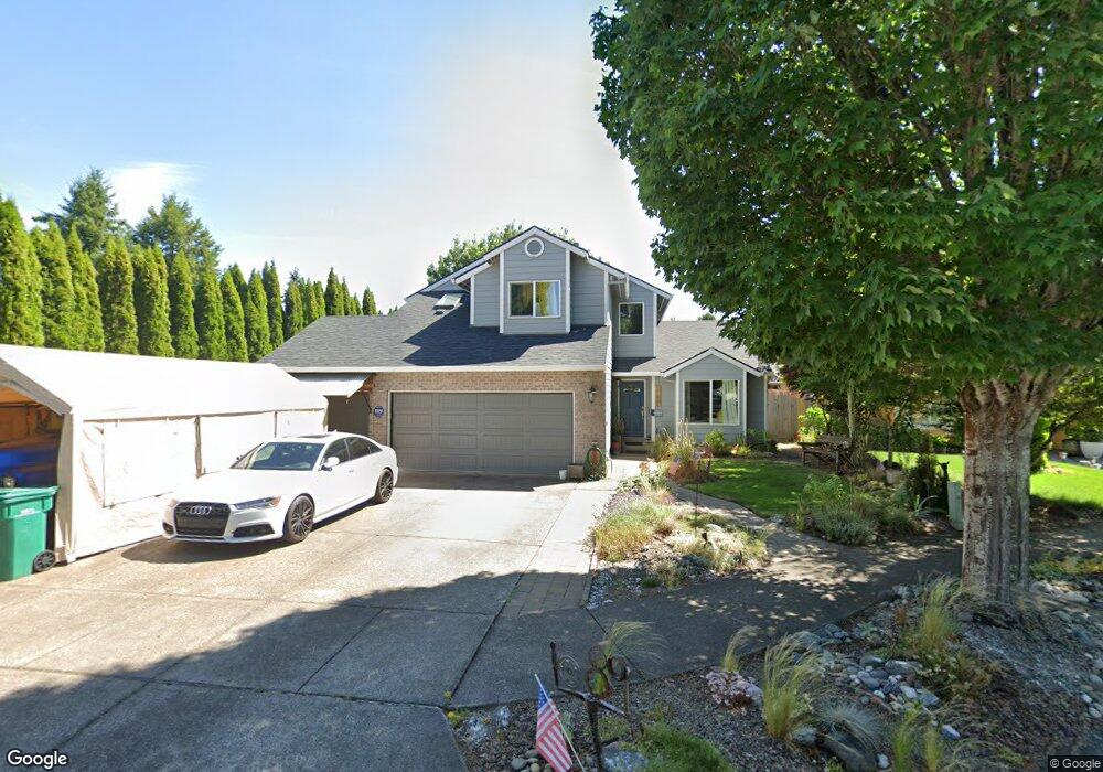
1089 Cedar St Forest Grove, OR 97116
Estimated Value: $520,000 - $588,000
3
Beds
3
Baths
1,846
Sq Ft
$297/Sq Ft
Est. Value
About This Home
This home is located at 1089 Cedar St, Forest Grove, OR 97116 and is currently estimated at $548,761, approximately $297 per square foot. 1089 Cedar St is a home located in Washington County with nearby schools including Joseph Gale Elementary School, Tom McCall Upper Elementary School, and Neil Armstrong Middle School.
Ownership History
Date
Name
Owned For
Owner Type
Purchase Details
Closed on
Mar 8, 2016
Sold by
Wells Fargo Bank Na
Bought by
U S Bank Trust Na and Lsf9 Master Participation Trust
Current Estimated Value
Home Financials for this Owner
Home Financials are based on the most recent Mortgage that was taken out on this home.
Original Mortgage
$279,775
Outstanding Balance
$220,152
Interest Rate
3.64%
Mortgage Type
New Conventional
Estimated Equity
$328,609
Purchase Details
Closed on
Mar 7, 2016
Sold by
U S Bank Trust Na
Bought by
Silva Shawn A and Silva Anita E
Home Financials for this Owner
Home Financials are based on the most recent Mortgage that was taken out on this home.
Original Mortgage
$279,775
Outstanding Balance
$220,152
Interest Rate
3.64%
Mortgage Type
New Conventional
Estimated Equity
$328,609
Purchase Details
Closed on
Nov 3, 2015
Sold by
Hansen David Michael and Hansen Diane Lynn
Bought by
Wells Fargo Bank Na
Purchase Details
Closed on
Jan 16, 2008
Sold by
Hansen David Michael
Bought by
Hansen David Michael and Hansen Diane Lynn
Home Financials for this Owner
Home Financials are based on the most recent Mortgage that was taken out on this home.
Original Mortgage
$240,000
Interest Rate
6.05%
Mortgage Type
New Conventional
Purchase Details
Closed on
Jan 4, 2008
Sold by
Hansen David Michael and Hansen Diane Lynn
Bought by
Hansen David Michael
Home Financials for this Owner
Home Financials are based on the most recent Mortgage that was taken out on this home.
Original Mortgage
$240,000
Interest Rate
6.05%
Mortgage Type
New Conventional
Purchase Details
Closed on
Nov 13, 1995
Sold by
Amt Resources Ltd
Bought by
Hansen David Michael and Hansen Diane Lynn
Home Financials for this Owner
Home Financials are based on the most recent Mortgage that was taken out on this home.
Original Mortgage
$143,900
Interest Rate
7.42%
Purchase Details
Closed on
Mar 28, 1995
Sold by
Amt Resources Ltd
Bought by
Forest Grove School District #15
Create a Home Valuation Report for This Property
The Home Valuation Report is an in-depth analysis detailing your home's value as well as a comparison with similar homes in the area
Home Values in the Area
Average Home Value in this Area
Purchase History
| Date | Buyer | Sale Price | Title Company |
|---|---|---|---|
| U S Bank Trust Na | -- | First American | |
| Silva Shawn A | $294,500 | First American | |
| Wells Fargo Bank Na | $248,710 | None Available | |
| Hansen David Michael | -- | Accommodation | |
| Hansen David Michael | -- | Security Title | |
| Hansen David Michael | $159,900 | First American Title Ins Co | |
| Forest Grove School District #15 | $31,200 | First American Title Ins Co |
Source: Public Records
Mortgage History
| Date | Status | Borrower | Loan Amount |
|---|---|---|---|
| Open | Silva Shawn A | $279,775 | |
| Previous Owner | Hansen David Michael | $240,000 | |
| Previous Owner | Hansen David Michael | $143,900 |
Source: Public Records
Tax History Compared to Growth
Tax History
| Year | Tax Paid | Tax Assessment Tax Assessment Total Assessment is a certain percentage of the fair market value that is determined by local assessors to be the total taxable value of land and additions on the property. | Land | Improvement |
|---|---|---|---|---|
| 2026 | $5,238 | $294,140 | -- | -- |
| 2025 | $5,238 | $285,580 | -- | -- |
| 2024 | $5,053 | $277,270 | -- | -- |
| 2023 | $5,053 | $269,200 | $0 | $0 |
| 2022 | $4,419 | $269,200 | $0 | $0 |
| 2021 | $4,361 | $253,750 | $0 | $0 |
| 2020 | $4,338 | $246,360 | $0 | $0 |
| 2019 | $4,241 | $239,190 | $0 | $0 |
| 2018 | $4,111 | $232,230 | $0 | $0 |
| 2017 | $3,984 | $225,470 | $0 | $0 |
| 2016 | $3,872 | $218,910 | $0 | $0 |
| 2015 | $3,723 | $212,540 | $0 | $0 |
| 2014 | $3,705 | $206,350 | $0 | $0 |
Source: Public Records
Map
Nearby Homes