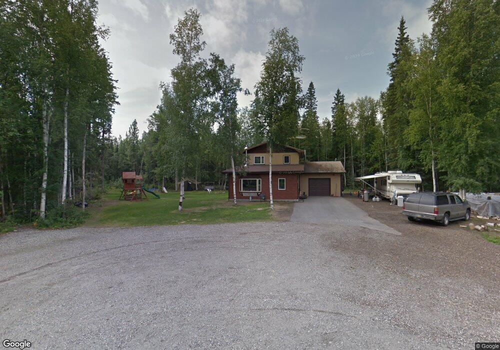
1089 Oak Crest Ct North Pole, AK 99705
Badger NeighborhoodEstimated Value: $224,000 - $344,000
--
Bed
1
Bath
2,208
Sq Ft
$131/Sq Ft
Est. Value
About This Home
This home is located at 1089 Oak Crest Ct, North Pole, AK 99705 and is currently estimated at $290,168, approximately $131 per square foot. 1089 Oak Crest Ct is a home located in Fairbanks North Star Borough with nearby schools including Ticasuk Brown Elementary School, North Pole Middle School, and North Pole High School.
Ownership History
Date
Name
Owned For
Owner Type
Purchase Details
Closed on
Jun 28, 2016
Sold by
Smith Ronald P and Smith April L
Bought by
Dunning David C
Current Estimated Value
Home Financials for this Owner
Home Financials are based on the most recent Mortgage that was taken out on this home.
Original Mortgage
$209,407
Outstanding Balance
$167,170
Interest Rate
3.58%
Estimated Equity
$122,998
Purchase Details
Closed on
Jan 24, 2005
Sold by
Smith Ronald P
Bought by
Smith Ronald P and Smith April L
Purchase Details
Closed on
Dec 14, 2001
Sold by
Hovda Donald R and Hovda Kathleen
Bought by
Smith Ronald P
Home Financials for this Owner
Home Financials are based on the most recent Mortgage that was taken out on this home.
Original Mortgage
$120,258
Interest Rate
6.57%
Create a Home Valuation Report for This Property
The Home Valuation Report is an in-depth analysis detailing your home's value as well as a comparison with similar homes in the area
Home Values in the Area
Average Home Value in this Area
Purchase History
| Date | Buyer | Sale Price | Title Company |
|---|---|---|---|
| Dunning David C | -- | None Available | |
| Smith Ronald P | -- | -- | |
| Smith Ronald P | -- | Fairbanks Title Agency Inc |
Source: Public Records
Mortgage History
| Date | Status | Borrower | Loan Amount |
|---|---|---|---|
| Open | Dunning David C | $209,407 | |
| Previous Owner | Smith Ronald P | $120,258 |
Source: Public Records
Tax History Compared to Growth
Tax History
| Year | Tax Paid | Tax Assessment Tax Assessment Total Assessment is a certain percentage of the fair market value that is determined by local assessors to be the total taxable value of land and additions on the property. | Land | Improvement |
|---|---|---|---|---|
| 2025 | $4,186 | $268,229 | $15,812 | $252,417 |
| 2024 | $4,022 | $258,901 | $15,812 | $243,089 |
| 2023 | $3,983 | $258,901 | $15,812 | $243,089 |
| 2022 | $4,100 | $237,461 | $15,812 | $221,649 |
| 2021 | $3,885 | $204,506 | $15,812 | $188,694 |
| 2020 | $3,723 | $193,630 | $15,812 | $177,818 |
| 2019 | $3,706 | $193,644 | $15,812 | $177,832 |
| 2018 | $3,470 | $194,188 | $15,812 | $178,376 |
| 2017 | $3,165 | $189,058 | $15,812 | $173,246 |
| 2016 | $2,974 | $183,135 | $15,812 | $167,323 |
| 2015 | $2,557 | $180,174 | $15,812 | $164,362 |
| 2014 | $2,557 | $180,174 | $15,812 | $164,362 |
Source: Public Records
Map
Nearby Homes
- 1108 Ichabod St
- 944 Agnes Ln
- 1089 Eliz St
- 2432 Whitman Rd
- 1244 Candle Lite Loop
- 2460 Sharptail Ct
- 1370 Ric Dr
- 2310 Bradway Rd
- 1300 Becky St
- 2602 Lisa Ann Dr
- 1306 Hartzog Loop
- 2385 Dano Ct
- 2658 Clydesdale Dr
- 2441 Baby Bell Dr
- 2309 Blue Sparkle Dr
- 2300 Moonlight Dr
- 1564 Madeline St
- 1642 Palomino Dr
- 2030 Haydon Ct
- NHN Benji Ct
- 1090 Oak Crest Ct
- 1100 Vincent Ct
- 1113 Vincent Ct
- 1070 Oak Crest Ct
- 1104 Vincent Ct
- 1069 Oak Crest Ct
- 1095 Brock Rd
- 1118 Vincent Ct
- 2623 Peede Rd
- 1078 Vincent Ct
- 1091 Vincent Ct
- 1075 Brock Rd
- 1081 Vincent Ct
- 1068 Vincent Ct
- 1146 Vincent Ct
- 2620 Muskeg Ln
- 1155 Vincent Ct
- 1122 Vincent Ct
- 1205 Vincent Ct