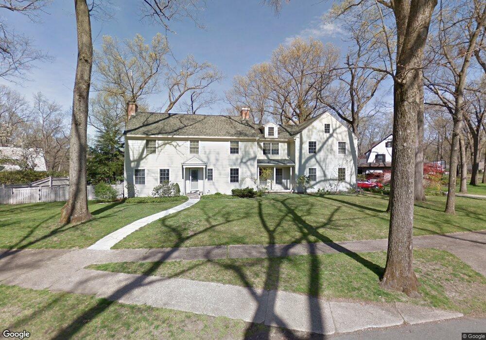
109 Colony Rd Longmeadow, MA 01106
Estimated Value: $997,000 - $1,067,000
4
Beds
5
Baths
2,995
Sq Ft
$349/Sq Ft
Est. Value
About This Home
This home is located at 109 Colony Rd, Longmeadow, MA 01106 and is currently estimated at $1,044,955, approximately $348 per square foot. 109 Colony Rd is a home located in Hampden County with nearby schools including Blueberry Hill, Williams Middle School, and Longmeadow High School.
Ownership History
Date
Name
Owned For
Owner Type
Purchase Details
Closed on
Dec 27, 2016
Sold by
Mcafee Paul M and Crowley Monica T
Bought by
Crowley Monica T
Current Estimated Value
Purchase Details
Closed on
Sep 2, 2003
Sold by
Kouroupas Maria E and Kouroupas Stephen J
Bought by
Crowley Monica T and Mcafee Paul A
Home Financials for this Owner
Home Financials are based on the most recent Mortgage that was taken out on this home.
Original Mortgage
$375,000
Interest Rate
5.69%
Mortgage Type
Purchase Money Mortgage
Purchase Details
Closed on
Feb 28, 1997
Sold by
Carman Paul W
Bought by
Kouroupas Stephen J and Kouroupas Maria E
Purchase Details
Closed on
Sep 4, 1992
Sold by
Carroll Mary L and Carroll Edward J
Bought by
Carman Paul W
Create a Home Valuation Report for This Property
The Home Valuation Report is an in-depth analysis detailing your home's value as well as a comparison with similar homes in the area
Home Values in the Area
Average Home Value in this Area
Purchase History
| Date | Buyer | Sale Price | Title Company |
|---|---|---|---|
| Crowley Monica T | -- | -- | |
| Crowley Monica T | $575,000 | -- | |
| Kouroupas Stephen J | $303,000 | -- | |
| Carman Paul W | $241,500 | -- |
Source: Public Records
Mortgage History
| Date | Status | Borrower | Loan Amount |
|---|---|---|---|
| Previous Owner | Carman Paul W | $478,000 | |
| Previous Owner | Crowley Monica T | $375,000 | |
| Previous Owner | Carman Paul W | $278,000 | |
| Previous Owner | Carman Paul W | $33,000 |
Source: Public Records
Tax History Compared to Growth
Tax History
| Year | Tax Paid | Tax Assessment Tax Assessment Total Assessment is a certain percentage of the fair market value that is determined by local assessors to be the total taxable value of land and additions on the property. | Land | Improvement |
|---|---|---|---|---|
| 2025 | $20,558 | $973,400 | $260,700 | $712,700 |
| 2024 | $20,130 | $973,400 | $260,700 | $712,700 |
| 2023 | $19,019 | $829,800 | $187,200 | $642,600 |
| 2022 | $18,418 | $747,500 | $187,200 | $560,300 |
| 2021 | $18,303 | $739,800 | $200,500 | $539,300 |
| 2020 | $18,017 | $744,200 | $215,400 | $528,800 |
| 2019 | $17,133 | $711,200 | $215,400 | $495,800 |
| 2018 | $19,275 | $791,900 | $294,700 | $497,200 |
| 2017 | $18,673 | $791,900 | $294,700 | $497,200 |
| 2016 | $17,980 | $739,000 | $272,000 | $467,000 |
| 2015 | $17,398 | $736,600 | $269,600 | $467,000 |
Source: Public Records
Map
Nearby Homes
- 44 Wendover Rd
- 114 Park Dr
- 19 Normandy Rd
- 0 Eunice Dr Unit 73446102
- 260 Longmeadow St
- 118 Field Rd
- 32 Edgewood Ave
- 50 Elmwood Ave
- 106 Magnolia Terrace
- 283 Longhill St
- 52 Smithfield Ct
- 80 Williamsburg Dr Unit 8
- 96 Firglade Ave
- 65 Firglade Ave
- 32 Spruceland Ave
- 15 Bronson Terrace
- 82-84 Maryland St
- 124 Tecumseh Dr
- 11 Copeland St
- 34 Sumner Ave Unit 314