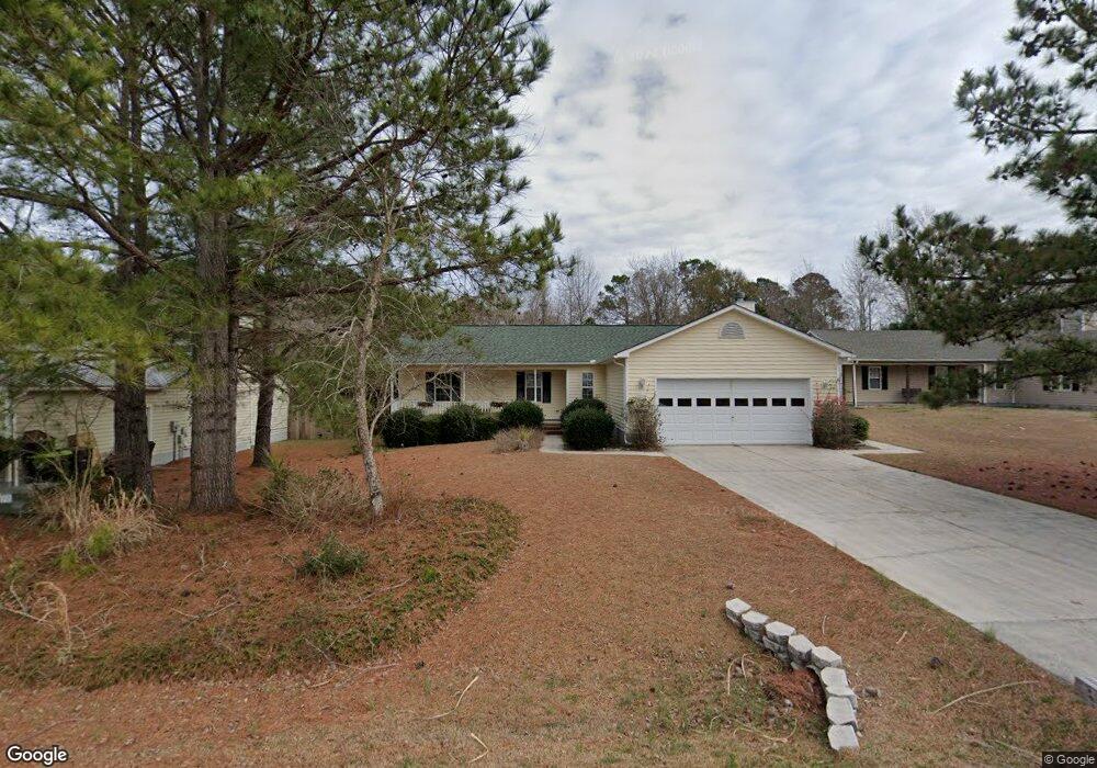
109 Freeport Ct Hubert, NC 28539
Hubert NeighborhoodEstimated Value: $243,000 - $268,000
3
Beds
2
Baths
1,382
Sq Ft
$188/Sq Ft
Est. Value
About This Home
This home is located at 109 Freeport Ct, Hubert, NC 28539 and is currently estimated at $259,872, approximately $188 per square foot. 109 Freeport Ct is a home located in Onslow County with nearby schools including Queens Creek Elementary School, Swansboro Middle School, and Swansboro High School.
Ownership History
Date
Name
Owned For
Owner Type
Purchase Details
Closed on
Apr 2, 2005
Sold by
Atlantic Construction Inc
Bought by
Shaw Carol J
Current Estimated Value
Home Financials for this Owner
Home Financials are based on the most recent Mortgage that was taken out on this home.
Original Mortgage
$14,900
Outstanding Balance
$7,789
Interest Rate
5.98%
Mortgage Type
New Conventional
Estimated Equity
$252,083
Create a Home Valuation Report for This Property
The Home Valuation Report is an in-depth analysis detailing your home's value as well as a comparison with similar homes in the area
Home Values in the Area
Average Home Value in this Area
Purchase History
We collect this data history from publicly available records. To have your information removed, we recommend requesting removal directly through your county’s website.
| Date | Buyer | Sale Price | Title Company |
|---|---|---|---|
| Shaw Carol J | $115,000 | None Available |
Source: Public Records
Mortgage History
We collect this data history from publicly available records. To have your information removed, we recommend requesting removal directly through your county’s website.
| Date | Status | Borrower | Loan Amount |
|---|---|---|---|
| Open | Shaw Carol J | $14,900 |
Source: Public Records
Tax History
| Year | Tax Paid | Tax Assessment Tax Assessment Total Assessment is a certain percentage of the fair market value that is determined by local assessors to be the total taxable value of land and additions on the property. | Land | Improvement |
|---|---|---|---|---|
| 2025 | $1,181 | $180,240 | $40,000 | $140,240 |
| 2024 | $1,181 | $180,240 | $40,000 | $140,240 |
| 2023 | $1,181 | $180,240 | $40,000 | $140,240 |
| 2022 | $1,181 | $180,240 | $40,000 | $140,240 |
| 2021 | $967 | $137,120 | $30,000 | $107,120 |
| 2020 | $967 | $137,120 | $30,000 | $107,120 |
| 2019 | $967 | $137,120 | $30,000 | $107,120 |
| 2018 | $967 | $137,120 | $30,000 | $107,120 |
| 2017 | $998 | $147,830 | $38,000 | $109,830 |
| 2016 | $998 | $147,830 | $0 | $0 |
| 2015 | $998 | $147,830 | $0 | $0 |
| 2014 | $998 | $147,830 | $0 | $0 |
Source: Public Records
Map
Nearby Homes
- 107 Freeport Ct
- 111 Freeport Ct
- 113 Freeport Ct
- 105 Freeport Ct
- 112 Freeport Ct
- 106 Freeport Ct
- 104 Freeport Ct
- 116 Wilburne Dr
- 103 Freeport Ct
- 110 Freeport Ct
- 103 Freeport Ct
- 101 Freeport Ct
- 128 Henson Rd
- 731 Queens Creek Rd
- 100 Freeport Ct
- 733 Queens Creek Rd
- 132 Wilburne Dr
- 737 Queens Creek Rd
- 106 Henson Rd
- 206 Morse Dr
Your Personal Tour Guide
Ask me questions while you tour the home.