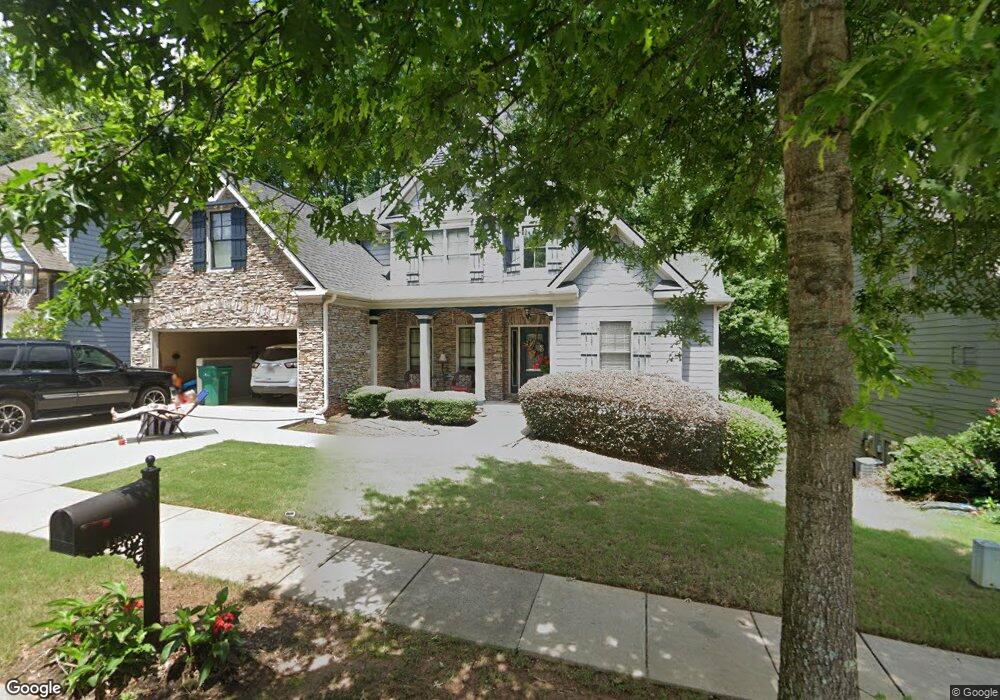
109 Manous Dr Canton, GA 30115
Estimated Value: $454,618 - $479,000
4
Beds
3
Baths
2,139
Sq Ft
$218/Sq Ft
Est. Value
About This Home
This home is located at 109 Manous Dr, Canton, GA 30115 and is currently estimated at $466,809, approximately $218 per square foot. 109 Manous Dr is a home located in Cherokee County with nearby schools including Holly Springs Elementary School, Rusk Middle School, and Sequoyah High School.
Ownership History
Date
Name
Owned For
Owner Type
Purchase Details
Closed on
Jun 28, 2019
Sold by
Smith Johnnie M
Bought by
Smith Kimren and Smith Johnnie M
Current Estimated Value
Purchase Details
Closed on
Nov 20, 2015
Sold by
Torres Danette
Bought by
Smith Johnnie M
Home Financials for this Owner
Home Financials are based on the most recent Mortgage that was taken out on this home.
Original Mortgage
$220,924
Interest Rate
3.83%
Mortgage Type
FHA
Purchase Details
Closed on
Jun 28, 2013
Sold by
Renasant Bank
Bought by
Torres Dannette and Torres Virginia
Purchase Details
Closed on
Aug 30, 2012
Sold by
Construct Stanley Townsend
Bought by
Renasant Bank
Create a Home Valuation Report for This Property
The Home Valuation Report is an in-depth analysis detailing your home's value as well as a comparison with similar homes in the area
Home Values in the Area
Average Home Value in this Area
Purchase History
| Date | Buyer | Sale Price | Title Company |
|---|---|---|---|
| Smith Kimren | -- | -- | |
| Smith Johnnie M | $225,000 | -- | |
| Torres Dannette | $193,000 | -- | |
| Renasant Bank | -- | -- |
Source: Public Records
Mortgage History
| Date | Status | Borrower | Loan Amount |
|---|---|---|---|
| Previous Owner | Smith Johnnie M | $220,924 |
Source: Public Records
Tax History
| Year | Tax Paid | Tax Assessment Tax Assessment Total Assessment is a certain percentage of the fair market value that is determined by local assessors to be the total taxable value of land and additions on the property. | Land | Improvement |
|---|---|---|---|---|
| 2025 | $4,522 | $192,196 | $36,000 | $156,196 |
| 2024 | $983 | $173,280 | $34,000 | $139,280 |
| 2023 | $948 | $171,520 | $29,600 | $141,920 |
| 2022 | $1,006 | $151,480 | $24,800 | $126,680 |
| 2021 | $2,940 | $125,960 | $23,200 | $102,760 |
| 2020 | $3,546 | $113,880 | $20,800 | $93,080 |
| 2019 | $2,592 | $108,240 | $19,600 | $88,640 |
| 2018 | $3,342 | $102,640 | $18,800 | $83,840 |
| 2017 | $3,215 | $238,800 | $17,600 | $77,920 |
| 2016 | $2,348 | $228,100 | $16,800 | $74,440 |
| 2015 | $2,076 | $199,900 | $15,200 | $64,760 |
| 2014 | $1,881 | $180,700 | $15,200 | $57,080 |
Source: Public Records
Map
Nearby Homes
- 216 Manous Way
- 246 Manous Way
- 134 Childers Rd
- 3132 Holly Springs Pkwy
- 3072 Holly Springs Pkwy
- 1600 Mountain Trace
- 417 Crestmont Ln
- 415 Crestmont Ln
- 206 Sawtooth Ct
- 482 Palm St
- 152 Palm St
- 208 Sawtooth Ct
- 542 Palm St
- 164 Palm St
- 554 Palm St
- 107 Hidden Lake Cir
- 2550 Mountain Brook Rd
- 408 Candy Ln
- 116 Hidden Lake Cir
- 150 Hidden Lake Cir
- 107 Manous Dr
- 107 Manous Dr
- 107 Manous Dr Unit 52
- 106 Manous Dr
- 111 Manous Dr
- 104 Manous Dr
- 108 Manous Dr
- 110 Manous Dr
- 113 Manous Dr
- 203 Manous Way
- 112 Manous Dr
- 200 Manous Way
- 205 Manous Way
- 115 Manous Dr
- 207 Manous Way
- 0 Manous Dr
- 0 Manous Dr Unit 3285310
- 114 Manous Dr
- 209 Manous Way Unit 70
- 209 Manous Way
Your Personal Tour Guide
Ask me questions while you tour the home.