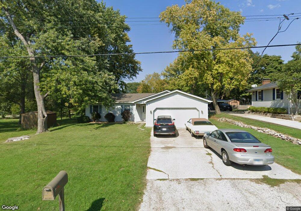
109 Mark Dr Collinsville, IL 62234
Estimated Value: $215,000 - $266,000
4
Beds
2
Baths
1,428
Sq Ft
$162/Sq Ft
Est. Value
About This Home
This home is located at 109 Mark Dr, Collinsville, IL 62234 and is currently estimated at $231,991, approximately $162 per square foot. 109 Mark Dr is a home located in Madison County with nearby schools including John A Renfro Elementary School, Dorris Intermediate School, and Collinsville Middle School.
Ownership History
Date
Name
Owned For
Owner Type
Purchase Details
Closed on
Oct 29, 2004
Sold by
Martin Keith A
Bought by
Mitchell Shaun G and Mitchell Carrie E
Current Estimated Value
Home Financials for this Owner
Home Financials are based on the most recent Mortgage that was taken out on this home.
Original Mortgage
$110,400
Outstanding Balance
$55,203
Interest Rate
5.81%
Mortgage Type
Purchase Money Mortgage
Estimated Equity
$176,788
Create a Home Valuation Report for This Property
The Home Valuation Report is an in-depth analysis detailing your home's value as well as a comparison with similar homes in the area
Home Values in the Area
Average Home Value in this Area
Purchase History
| Date | Buyer | Sale Price | Title Company |
|---|---|---|---|
| Mitchell Shaun G | $138,000 | Abstracts & Titles Inc |
Source: Public Records
Mortgage History
| Date | Status | Borrower | Loan Amount |
|---|---|---|---|
| Open | Mitchell Shaun G | $110,400 | |
| Closed | Mitchell Shaun G | $27,600 |
Source: Public Records
Tax History Compared to Growth
Tax History
| Year | Tax Paid | Tax Assessment Tax Assessment Total Assessment is a certain percentage of the fair market value that is determined by local assessors to be the total taxable value of land and additions on the property. | Land | Improvement |
|---|---|---|---|---|
| 2024 | $3,657 | $63,200 | $14,540 | $48,660 |
| 2023 | $3,657 | $58,500 | $13,460 | $45,040 |
| 2022 | $3,455 | $54,100 | $12,450 | $41,650 |
| 2021 | $3,042 | $50,040 | $11,460 | $38,580 |
| 2020 | $2,913 | $47,740 | $10,930 | $36,810 |
| 2019 | $2,822 | $46,110 | $10,560 | $35,550 |
| 2018 | $2,745 | $43,680 | $10,000 | $33,680 |
| 2017 | $3,031 | $46,730 | $10,470 | $36,260 |
| 2016 | $3,183 | $46,730 | $10,470 | $36,260 |
| 2015 | $2,958 | $45,520 | $10,200 | $35,320 |
| 2014 | $2,958 | $45,520 | $10,200 | $35,320 |
| 2013 | $2,958 | $45,520 | $10,200 | $35,320 |
Source: Public Records
Map
Nearby Homes
- 102 Toni Ct
- 300 Pine Lake Rd Unit 6
- 300 Pine Lake Rd Unit 7
- 706 Illinois Ave
- 203 Greenfield Dr
- 2 Chelsea Rd
- 1227 Ridge Ave
- 0 N Keebler Ave
- 1002 California Ave
- 112 Crestmoor St
- 625 W Country Ln
- 892 Lester Ave
- 1120 Williams St
- 1210 Constance St
- 1322 Leland St
- 10 White Lily Dr
- 1224 Cedar Ridge Ct
- 308 Brown Ave
- 131 E Country Ln
- 414 Bunker Hill Dr
- 107 Mark Dr
- 1700 Golfview Dr
- 1605 Frederick Dr
- 1702 Golfview Dr
- 1607 Frederick Dr
- 108 Mark Dr
- 106 Mark Dr
- 110 Mark Dr
- 1609 Frederick Dr
- 1704 Golfview Dr
- 1603 Frederick Dr
- 1602 Golfview Dr
- LT 1 Northtowne Woods
- 1608 Frederick Dr
- 1606 Frederick Dr
- 1610 Frederick Dr
- 1604 Frederick Dr
- 1612 Frederick Dr
- 2 Par Dr
- 1602 Frederick Dr