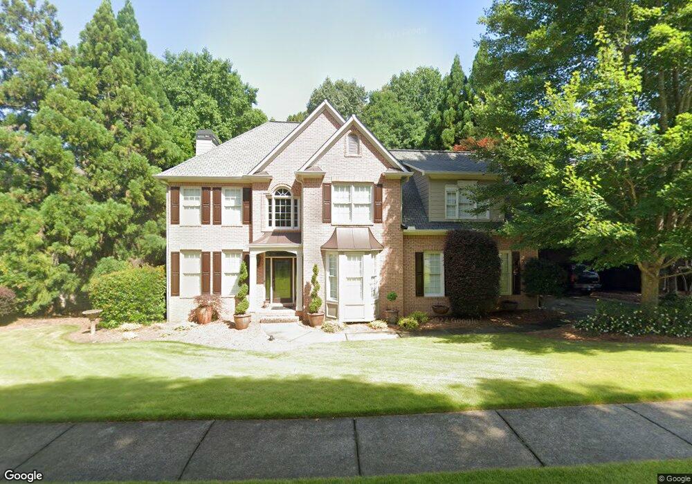
109 Misty Valley Dr Canton, GA 30114
Sutallee NeighborhoodEstimated Value: $561,478 - $565,000
4
Beds
3
Baths
2,790
Sq Ft
$202/Sq Ft
Est. Value
About This Home
This home is located at 109 Misty Valley Dr, Canton, GA 30114 and is currently estimated at $563,239, approximately $201 per square foot. 109 Misty Valley Dr is a home located in Cherokee County with nearby schools including Sixes Elementary School, Freedom Middle School, and Woodstock High School.
Ownership History
Date
Name
Owned For
Owner Type
Purchase Details
Closed on
Feb 17, 2000
Sold by
Blueridge Residential Inc
Bought by
Beauchamp Richard W and Beauchamp Linda M
Current Estimated Value
Home Financials for this Owner
Home Financials are based on the most recent Mortgage that was taken out on this home.
Original Mortgage
$233,700
Outstanding Balance
$76,318
Interest Rate
8.21%
Mortgage Type
New Conventional
Estimated Equity
$486,921
Create a Home Valuation Report for This Property
The Home Valuation Report is an in-depth analysis detailing your home's value as well as a comparison with similar homes in the area
Home Values in the Area
Average Home Value in this Area
Purchase History
| Date | Buyer | Sale Price | Title Company |
|---|---|---|---|
| Beauchamp Richard W | $246,100 | -- |
Source: Public Records
Mortgage History
| Date | Status | Borrower | Loan Amount |
|---|---|---|---|
| Open | Beauchamp Richard W | $233,700 |
Source: Public Records
Tax History Compared to Growth
Tax History
| Year | Tax Paid | Tax Assessment Tax Assessment Total Assessment is a certain percentage of the fair market value that is determined by local assessors to be the total taxable value of land and additions on the property. | Land | Improvement |
|---|---|---|---|---|
| 2025 | $4,952 | $212,624 | $50,000 | $162,624 |
| 2024 | $4,745 | $203,232 | $46,000 | $157,232 |
| 2023 | $4,192 | $197,600 | $46,000 | $151,600 |
| 2022 | $3,906 | $161,200 | $36,000 | $125,200 |
| 2021 | $3,579 | $133,160 | $28,800 | $104,360 |
| 2020 | $3,397 | $125,160 | $28,800 | $96,360 |
| 2019 | $3,233 | $118,120 | $28,800 | $89,320 |
| 2018 | $3,087 | $111,080 | $27,200 | $83,880 |
| 2017 | $3,079 | $274,300 | $27,200 | $82,520 |
| 2016 | $2,980 | $261,700 | $27,200 | $77,480 |
| 2015 | $2,781 | $242,200 | $24,000 | $72,880 |
| 2014 | $2,712 | $235,900 | $24,000 | $70,360 |
Source: Public Records
Map
Nearby Homes
- 829 Valley Dr
- 834 Valley Dr Unit 1K
- 711 Tall Oaks Dr
- 302 Magnolia Trace
- 414 Dogwood Way
- 601 Redwood Ln
- 644 Gold Valley Pass
- 164 Henley St
- 106 Birchwood Pass
- 160 Henley St Unit 15
- 160 Henley St
- 664 Gold Valley Pass
- Jasper II Plan at Cambridge at Steels Bridge
- Newton II Plan at Cambridge at Steels Bridge
- Fulton II Plan at Cambridge at Steels Bridge
- Brookwood Plan at Cambridge at Steels Bridge
- Tifton II Plan at Cambridge at Steels Bridge
- 304 Trecastle Ln
- 304 Trecastle Ln Unit 28
- 302 Trecastle Ln Unit 27
- 111 Misty Valley Dr Unit 1H
- 107 Misty Valley Dr
- 105 Misty Valley Dr
- 110 Misty Valley Dr
- 114 Misty Valley Dr
- 112 Misty Valley Dr
- 113 Misty Valley Dr
- 108 Misty Valley Dr
- 203 Misty Valley Ct
- 103 Misty Valley Dr
- 106 Misty Valley Dr
- 116 Misty Valley Dr
- 104 Misty Valley Dr
- 118 Misty Valley Dr
- 102 Misty Valley Dr
- 208 Willow View Ct
- 825 Valley Dr
- 316 Woodbrook Crest
- 827 Valley Dr
- 101 Misty Valley Dr