Estimated Value: $860,000 - $972,000
4
Beds
3
Baths
2,218
Sq Ft
$410/Sq Ft
Est. Value
About This Home
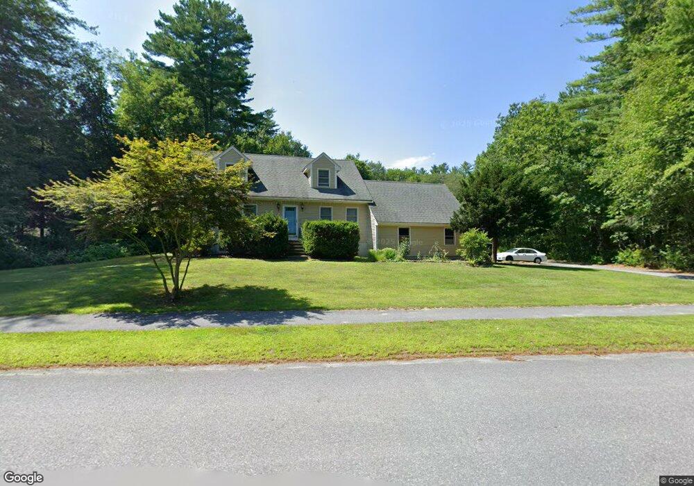
This home is located at 109 Nonset Path, Acton, MA 01720 and is currently estimated at $910,317, approximately $410 per square foot. 109 Nonset Path is a home located in Middlesex County with nearby schools including Acton-Boxborough Regional High School and Oak Meadow Montessori School.
Ownership History
Date
Name
Owned For
Owner Type
Purchase Details
Closed on
Jul 6, 1988
Sold by
Howell Richard G
Bought by
Marlborough Coop Bk
Current Estimated Value
Create a Home Valuation Report for This Property
The Home Valuation Report is an in-depth analysis detailing your home's value as well as a comparison with similar homes in the area
Home Values in the Area
Average Home Value in this Area
Purchase History
| Date | Buyer | Sale Price | Title Company |
|---|---|---|---|
| Marlborough Coop Bk | $329,190 | -- |
Source: Public Records
Mortgage History
| Date | Status | Borrower | Loan Amount |
|---|---|---|---|
| Open | Marlborough Coop Bk | $141,000 | |
| Closed | Marlborough Coop Bk | $172,000 | |
| Closed | Marlborough Coop Bk | $227,150 |
Source: Public Records
Tax History Compared to Growth
Tax History
| Year | Tax Paid | Tax Assessment Tax Assessment Total Assessment is a certain percentage of the fair market value that is determined by local assessors to be the total taxable value of land and additions on the property. | Land | Improvement |
|---|---|---|---|---|
| 2025 | $13,175 | $768,200 | $317,300 | $450,900 |
| 2024 | $12,432 | $745,800 | $317,300 | $428,500 |
| 2023 | $12,587 | $716,800 | $288,300 | $428,500 |
| 2022 | $11,390 | $585,600 | $251,200 | $334,400 |
| 2021 | $11,584 | $572,600 | $245,300 | $327,300 |
| 2020 | $10,620 | $552,000 | $245,300 | $306,700 |
| 2019 | $10,245 | $528,900 | $245,300 | $283,600 |
| 2018 | $10,068 | $519,500 | $245,300 | $274,200 |
| 2017 | $10,102 | $530,000 | $245,300 | $284,700 |
| 2016 | $9,578 | $498,100 | $245,300 | $252,800 |
| 2015 | $9,493 | $498,300 | $245,300 | $253,000 |
| 2014 | $9,262 | $476,200 | $245,300 | $230,900 |
Source: Public Records
Map
Nearby Homes
- 601 Old Stone Brook
- 405 Great Elm Way
- 1 Beth Cir Unit 1
- 49 Quarry Rd Unit 49
- 390 Great Rd Unit B16
- 1 Quarry Rd
- 159 Skyline Dr Unit 159
- 388 Great Rd Unit B14
- 386 Great Rd Unit A8
- 927 Main St
- 84 Powers Rd
- 875 Acton St
- 524 Main St
- 35 Queen Rd
- 709 Main St
- 16 Fletcher Ln
- 18 Long Lake Rd
- 33 Meadowbrook Rd
- 26 Long Lake Rd
- 254 Concord Rd Unit Lot 2A
- 111 Nonset Path
- 107 Nonset Path
- 110 Nonset Path
- 25 Henley Rd
- 113 Nonset Path
- 112 Nonset Path
- 24 Henley Rd
- 24 Henley Rd
- 24 Henley Rd Unit 24
- 66 Pheasant Hill Rd Unit 668
- 641 Pheasant Hill
- 641 Pheasant Hill Unit 1
- 102 Nonset Path
- 802 Old Stone Brook
- 21 Henley Rd
- 621 Pheasant Hill
- 622 Pheasant Hill
- 623 Pheasant Hill
- 624 Pheasant Hill
- 625 Pheasant Hill