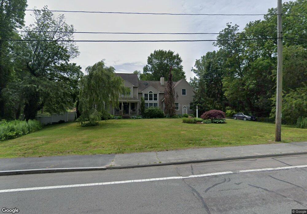
109 Old Westport Rd North Dartmouth, MA 02747
Estimated Value: $723,000 - $900,000
3
Beds
3
Baths
2,618
Sq Ft
$316/Sq Ft
Est. Value
About This Home
This home is located at 109 Old Westport Rd, North Dartmouth, MA 02747 and is currently estimated at $828,328, approximately $316 per square foot. 109 Old Westport Rd is a home located in Bristol County with nearby schools including Dartmouth High School, Friends Academy, and Nazarene Christian Academy.
Ownership History
Date
Name
Owned For
Owner Type
Purchase Details
Closed on
Jan 30, 1998
Sold by
Renaissance
Bought by
Mendes Richard J and Mendes Debra A
Current Estimated Value
Home Financials for this Owner
Home Financials are based on the most recent Mortgage that was taken out on this home.
Original Mortgage
$132,200
Outstanding Balance
$23,445
Interest Rate
7.02%
Mortgage Type
Purchase Money Mortgage
Estimated Equity
$804,883
Create a Home Valuation Report for This Property
The Home Valuation Report is an in-depth analysis detailing your home's value as well as a comparison with similar homes in the area
Home Values in the Area
Average Home Value in this Area
Purchase History
| Date | Buyer | Sale Price | Title Company |
|---|---|---|---|
| Mendes Richard J | $25,000 | -- |
Source: Public Records
Mortgage History
| Date | Status | Borrower | Loan Amount |
|---|---|---|---|
| Open | Mendes Richard J | $42,000 | |
| Closed | Mendes Richard J | $27,000 | |
| Open | Mendes Richard J | $132,200 |
Source: Public Records
Tax History Compared to Growth
Tax History
| Year | Tax Paid | Tax Assessment Tax Assessment Total Assessment is a certain percentage of the fair market value that is determined by local assessors to be the total taxable value of land and additions on the property. | Land | Improvement |
|---|---|---|---|---|
| 2025 | $6,327 | $699,100 | $191,100 | $508,000 |
| 2024 | $6,176 | $675,700 | $191,100 | $484,600 |
| 2023 | $6,243 | $644,300 | $191,100 | $453,200 |
| 2022 | $5,797 | $559,600 | $191,100 | $368,500 |
| 2021 | $5,665 | $523,100 | $185,600 | $337,500 |
| 2020 | $5,647 | $519,000 | $183,800 | $335,200 |
| 2019 | $5,425 | $500,000 | $176,300 | $323,700 |
| 2018 | $5,521 | $479,400 | $180,100 | $299,300 |
| 2017 | $4,722 | $443,800 | $166,400 | $277,400 |
| 2016 | $4,365 | $412,600 | $138,200 | $274,400 |
| 2015 | $4,270 | $406,300 | $129,000 | $277,300 |
| 2014 | $4,139 | $396,500 | $125,500 | $271,000 |
Source: Public Records
Map
Nearby Homes
- 135 Old Westport Rd
- 73 Gifford Ave
- 46 Old Westport Rd
- 28 Greystone Ave
- 1406 Tucker Rd
- Lot 6 Rafael Rd
- 0 Undisclosed Unit 73376281
- 65 Cross Rd
- 53 Morton Ave
- 32 Morton Ave
- 219 Chase Rd
- 310 Old Westport Rd
- 312 Old Westport Rd
- 24 Wayne Memorial Dr
- 320 Old Westport Rd
- 6 Strathmore Rd
- 0 Mosher Ln Unit 73370974
- 4 Sabrinas Way
- 4 Sabrina Way Unit A
- 4 Sabrina Way Unit C
- 101 Old Westport Rd
- 100 Old Westport Rd
- 100 Old Westport Rd Unit 1
- 20 Briarcliffe Ave
- 4 Chase Rd
- 121 Old Westport Rd
- 2 Chase Rd
- 000 Chase Rd
- 0 Chase Rd
- 1 Chase Rd
- 128 Old Westport Rd
- 14 Chase Rd
- 65 Longview Dr
- 127 Old Westport Rd
- 5 Chase Rd
- 61 Longview Dr
- 130 Old Westport Rd
- 41 Alcazar Ave
- 33 Alcazar Ave
- 129 Old Westport Rd